HUTAL, Afghanistan - Hydrologic engineer Bill Doan noted the tell-tale signs of water hidden all around him while walking a three-mile foot patrol with 15 Soldiers in the arid southern region of Afghanistan.
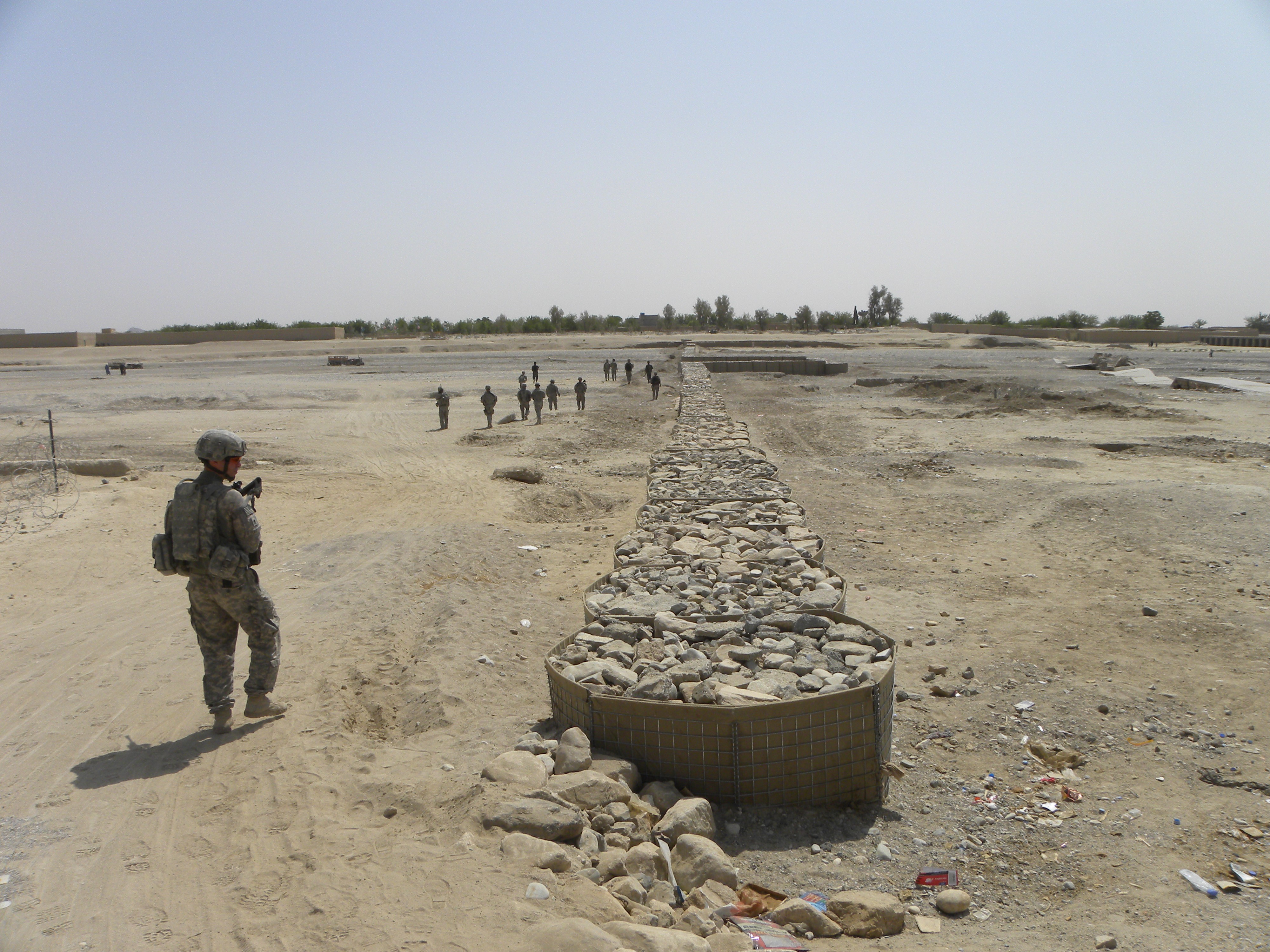
Doan and the Soldiers stationed at Combat Outpost Rath marched from the village of Hutal across the dry Luy Mandeh River, a quarter-mile wide swath of sand and rocks, where water hadn't run in months. They passed a recently built retention dam constructed of rock-filled containers that typically are used for blast walls.
Midway across the riverbed, which is called a wadi, the platoon came across four men shoveling sand into trailer hooked to a tractor. On the far side, they hiked upstream where the riverbed divided in two. Next to the smaller of the two riverbeds, they came upon a line of open pits denoting an ancient, but functional, underground water distribution channel called a karez.
Beyond that, Doan and the Soldiers encountered a couple of farmers tending irrigated fields of wheat and opium poppies, a flowering plant that's used to make heroin, which is Afghanistan's most profitable export.
U.S. officials hope to convince farmers in the region to switch from poppies to other crops, such as cotton, apricots, almonds and pomegranates, but those crops need far more water than poppies and water has been becoming increasingly scarce in the village of Hutal and the surrounding area.
Doan toured the site to assess whether - and how fast - the U.S. Army Corps of Engineers could design and build a dam or a series of dams in the region.
Corps of Engineers experts in Afghanistan and at five different offices in the United States are coordinating a comprehensive watershed study for southern and eastern Afghanistan, the most arid regions of the country. The goal of the $5.5 million study is to identify places to build dams and other water infrastructure projects.
"This is a perfect textbook example of the military strategy of clear, hold, build and transfer," Doan said. "This is the 'build' component of it."
Most of the work is being done using 3-D satellite mapping technology and geographic information systems, but Doan went to see Hutal at the request of Col. Gordon David, the civil affairs team leader at Rath, who believes a dam could help recharge the groundwater in the region.
"Instead of waiting for a year for all the assessments to get done, if it's obvious that this is a really, really good site, we can immediately get into the survey and design phase," said Doan, who's stationed at the U.S. Embassy in Kabul, 285 miles northeast of Hutal.
Reachback uses skills in North Carolina to site dams in Afghanistan
Hydrologists in North Carolina, in the Corps' Wilmington District, completed the first phase in October 2009. Similarly, hydrologists in four other regional offices are examining conditions in 16 more provinces. The second phase began early this year and is expected to be complete in about a year.
Hydrologists in Omaha, Neb., are examining Afghanistan's far southeastern provinces; while Mobile, Ala., has the central provinces. Fort Worth, Texas, has the northeast provinces and the Hydrologic Engineering Center in Davis, Calif., has the southwest and south-central provinces.
"Our reachback teams are actually doing the hardcore engineering work," Doan said referring to his counterparts in the United States. "They have some really good, high-quality GIS data and they can actually build 3-D terrain models and can look at it and say, 'Wow. That would be a good location for a dam right here.'"
Hydrologic engineers in the United States are considering a number of factors to identify potential sites, said Paul Ocker, chief of the Infrastructure and Planning Branch at the Corps of Engineers' headquarters north Afghanistan district in Kabul.
"They are going to look at a whole bunch of dam sites, and based on the economics of it, the need for agriculture in the area, on the sediment loads, on how much water we might be able to divert or store, based on all those factors, we'll decide where we design and eventually build small irrigation dams, water-supply dams and micro-hydro types of dams," Ocker said.
After the study is complete, the recommendations will be forwarded to the Corps of Engineers' two district headquarters in Afghanistan - Kabul in the north, and Kandahar in the south - to oversee the design and construction of potential projects.
There's plenty of possibilities. The first phase of the study examined just six provinces - Khost, Paktya, Logar, Wardack, Ghazni and Paktika. Together, they're 40,842 square miles, approximately the size of Kentucky.
Hydrologic engineers initially identified 185 prospective dam sites in the region, Ocker said. Corps of Engineers personnel then selected the top 15 sites, and then to the top five. Afghanistan has 34 provinces.
Officials expect that new dams will help Afghanistan rebuild its agricultural industry after three decades of war. The agriculture sector is a critical component of the country's economy, because approximately 80 percent of the country's workforce is involved in the trade, according to the 2010 CIA World Factbook, which compiles statistics on countries worldwide.
The dams also can be used for hydro-power plants and to recharge groundwater, said John Heitstuman, an engineer in the Kabul office.
Building the dam is just the beginning
Dam construction has four major components. In order: Restoring upstream watersheds to prevent erosion; designing and building the actual dams; installing new downstream infrastructure systems such as headgates and canals to deliver water to farmers and other users; and finally, teaching the locals the value of land management and how to operate the dams.
"Building the dam probably is the easiest part," Doan said.
Dams in Afghanistan are notorious for failing because of heavy sediment that piles up behind them, filling reservoirs intended to hold water, he said. The area around Hutal, like vast stretches throughout Afghanistan, is barren, at least in part, because of unregulated clear-cutting and overgrazing, which leads to erosion.
Ideally, a revegetation process using native trees, bushes and grasses would begin well before construction of a dam. "We'd let everything establish for one year, then actually build the dam. While the vegetation grows, it would hold back the sediment so that our dam doesn't fill up within a couple years," Doan said.
David envisions addressing a number of issues with a new permanent dam across the Luy Mandeh. The most important goal is recharging the underground water table by capturing flood water that runs eight feet deep during spring rains. Without a dam, the river swells during storms, but empties within a day or two with little affect on the water table.
"The long term benefit is to raise the water level after years of drought," David said. "A lot of the wells are dry. The water table has fallen and we're hoping that when the water does run down the wadi, it gets caught and stays a little longer to raise the water table. Half the wells are dry."
Dams will help with water and jobs
As recently as four years ago, people who live in the area were able to draw water from wells that were 30 meters deep, they said. Now, they must dig 50 or 60 meters before reaching water.
Additionally, David said, construction of a permanent dam would provide both short-term and long-term employment in the region, which has a population of about 30,000.
"These guys are about 80 percent unemployed, so they're constantly asking us for jobs," he said. "There's no other to make money, other than nickels and dimes out of the poppy trade or maybe an uncle has a shop at the bazaar," David said.
A dam would create immediate construction jobs, plus improve conditions for stable farming jobs, he said.
The Army paid about 90 local workers $6 each a day for three months to build the current retention dam using Hesco brand containers, which are made with metal and plastic mesh sidings and filled with sand and rocks. The workers dug the containers about three feet deep into the river bed. The barriers stand about five feet high.
The dam has been untested, because no rain has fallen since its completion earlier this year.
Doan noted other possible complications concerning a potential permanent dam across the Luy Mandeh - the impact on a cemetery and several existing houses constructed of mud along the river's banks, the effect on several karez channels in the area, and the potential for destructive overflows during flash floods.
In the end, Doan recommended a two-pronged approach - reinforcing the container check dam to reduce seepage between the individual containers and to prevent the containers from toppling; and designing and building a permanent dam.
Social Sharing