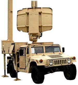
The AN/TPN-31 Air Traffic Navigation, Integration and Coordination System (ATNAVICS) is a highly mobile, self-contained, tactical Airport Surveillance Radar (ASR) and Precision Approach Radar (PAR) system that provides Air Traffic Service (ATS) at designated airfields and landing sites.
ATNAVICS provides ATS in all-weather conditions, night or day, for military and civilian aircraft. The ATNAVICS is a modular system that includes a mobile multi-radar platform, sheltered operations station, towed power plants and modernized, jam-resistant communications. The ATNAVICS is transportable by all standard land, rail, sea, fixed-wing and rotary wing transportation methods.
The ATNAVICS system facilitates air traffic movement by providing area navigational assistance, integrating air traffic during joint and combined operations and coordinating air movement within assigned airspace. The Army acquired the mobile tactical ATNAVICS system for improved airport surveillance, precision approach, and Identification, Friend or Foe/Selective Identification features.
ATNAVICS enhances the Combat Aviation Brigade’s F Company Air Traffic Control Ground Controlled Approach (GCA) team’s ability to provide air traffic services during inclement weather and instrument flight rules recovery operations of aviation platforms. This enables 15Q air traffic control Soldiers to provide area surveillance and aircraft identification capability for a 25 nautical mile (NM) radius (primary), 60 NM (secondary) with a modern, fully digital, FAA compliant ATC radar, able to see better through battlefield obscurants, weather, and natural phenomena such as bird flights. The system consists of three integrated radars: ASR, PAR, and secondary surveillance radar with seven air traffic controllers operating it.
The AN/TPN-31 normally deploys along with the Mobile Tower System (MOTS) as part of initial or follow-on forces to establish an all-weather, instrument landing capability at landing sites/airfields within the Joint Operations Area and theater areas of responsibility. Soldiers are capable of establishing GCA operations within 60 minutes of arrival in an area of operations. The system also enables GCA Soldiers to directly interface by voice and digital data links with the MOTS, Tactical Terminal Control System and Tactical Airspace Integration System of the combat aviation brigade, airfield operations battalion and division and theater airspace control elements for airspace data that supports current operations. When required, the ATNAVICS will also integrate into the national/host nation airspace system and comply with FAA, ICAO, NATO, and the European Organization for the Safety of Air Navigation standards for stability and civil support operations. Although the ATNAVICS is a tactical system, it can support Army requirements in a non-temporary, non-tactical type setting. The inherent flexibility of the ATNAVICS design also allows for its use in fixed base environments. ATNAVICS also has the ability to support multi-domain operations and enable Joint All Domain Command and Control with its 25 NM primary and 60 NM secondary radar surveillance capabilities. The ATNAVICS sensor is capable of connecting to the tactical network passing air track data to the air defense airspace management cells providing sensor gap coverage within a division’s area of responsibility potentially aiding in their reduction of sensor to shooter kill-chain time.
Download the Air Traffic Navigation, Integration and Coordination System (ATNAVICS) Fact Sheet [PDF - 352.4 KB]
Social Sharing