

FORT LEONARD WOOD, Mo. -- The Maneuver Support Center of Excellence Homeland Defense/Civil Support Office and Maneuver Support Battle Lab used a simulated earthquake scenario to evaluate new crisis-response technology for the Program Executive Office's Robotic Enhancement Program last week at Fort Leonard Wood's Urban Search and Rescue Training Area 235.
As part of the scenario, a 5.7-magnitude earthquake struck, collapsing a building and leaving roleplaying victims notionally trapped in a pile of rubble. The debris was used as a staging ground for deployed search-and-rescue devices.
The experiment was executed with input from U.S. Northern Command, the National Guard Bureau, U.S. Army Training and Doctrine Command and Army Futures Command.
Its goal was to determine the effectiveness of technologies that could provide military and civilian first responders a more accurate, remote look at Chemical, Biological, Radiological and Nuclear and other hazardous environments, such as natural disasters.
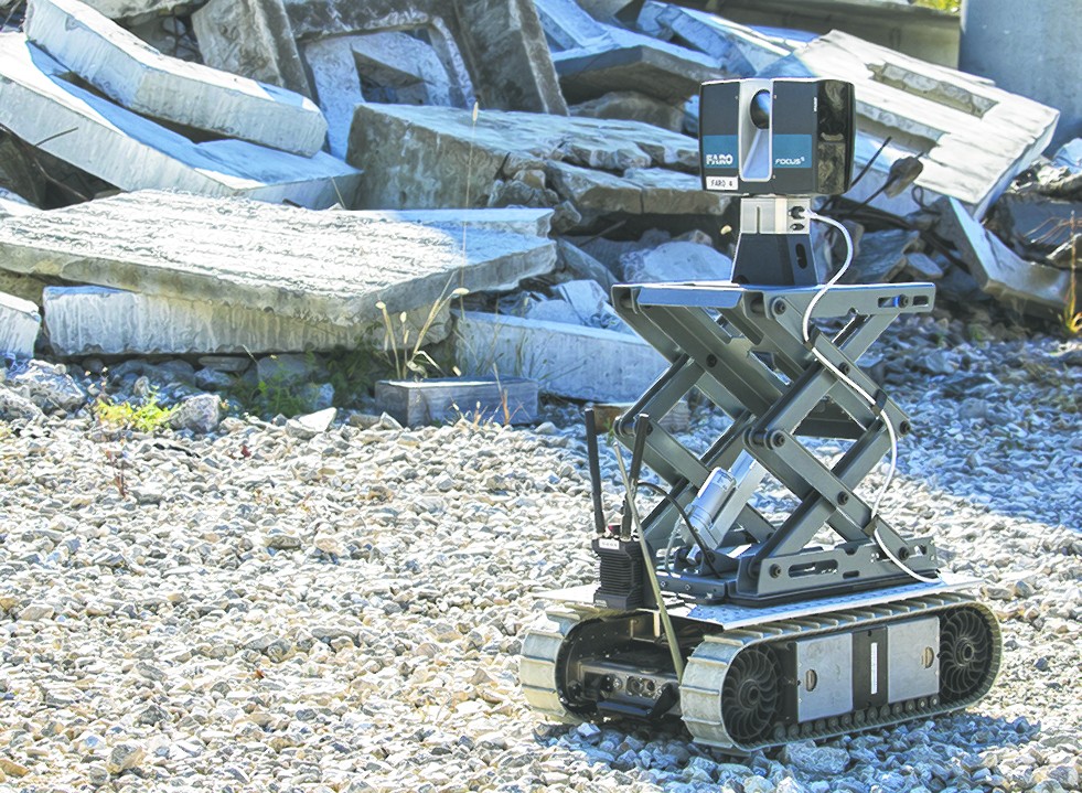
Officials tested three devices: Blackbird, a drone with both color and infrared cameras; the X3 FINDER, a device which its manufacturer says can detect heartbeats and respiration through 18 inches of concrete; and FARO Focus S 350, a 3D mapping and scanning apparatus, which can be mounted to a robot, such as Boston Dynamic's "dog."
"This is about improving readiness and protecting Soldiers," said Gregg Thompson, MSCoE deputy to the commanding general. "We want our people -- our No. 1 priority -- to have the capability to assess hazardous environments without exposure to the hazards."
Soldiers from the 95th Weapons of Mass Destruction Civil Support Team out of northern California, Army National Guard, and Missouri CBRN and Explosive Enhanced Response Force Package participated in the experiment, working with vendors from FARO Technologies Inc., SpecOps Group Inc. and Nightingale Security to see if the featured devices offered a reliable way to detect incapacitated victims while simultaneously protecting first responders.
In crisis response, CSTs support civil authorities and incident commanders -- sometimes civilian officials, such as fire and police chiefs -- who task the teams with knowing what kind of situation first responders can expect.
Time-to-action, reliability of intel and safe-site assessment are critical components to missions, like rescuing victims from hazardous situations, said Maj. Andrew Hanson, 95th CST commander.
"How quickly can I start making an assessment at a catastrophic incident, like this earthquake scenario? And how can I assess the scene from a safe distance?" he said. "I have to know, if I do send in these technologies ... is that assessment that I'm getting back of a high enough quality to advise an incident commander of what's going on in terms of victims and hazards?"
"That's why this experimentation and testing (are) important," Hanson said.
William Turner, a deployment engineer with Nightingale Security, which produces Blackbird, said the drone can assist ground teams in rapid communication, with thousands of military, law enforcement and first responder personnel being able to watch the drone's feed simultaneously.
"It's point to multipoint, so you can view these (video) streams from anywhere in the world on as many systems as you want," he said. "You could have thousands of viewers at once all across the world."
Michael Buckley, SpecOps Group Inc. director of training, said the 14-pound X3 FINDER is mobile, mountable and weather-resistant, capable of assisting emergency response crews in locating victims of hurricane flooding and damage.
The FARO Focus S 350 can scan and relay 3D models of structures back to commanders even in "complete darkness," said Scott Gershowitz, FARO account manager.
"For the commanders in the rear that aren't out there at the site, at the scene, they can get a visual 3D representation, to scale, of exactly what their troops are dealing with," he said.
Gershowitz added that the scanner has other applications for military and civilian responders such as post-blast analysis, crash reconstruction and accurate incident documentation for future learning opportunities.
Each of these devices relayed results back to Soldiers and U.S. Army North subject matter experts for near-real-time analysis at a command-and-control post.
"It is exciting to see the possibilities with unmanned systems and robotics, particularly seeing the potential applications across the board from WMD-CSTs to the whole of the CBRN Response Enterprise," Thompson said.
He commended the joint experiment on Fort Leonard Wood.
"The team here continues to do great things to support the Army's contributions to Homeland Defense and defense support to civil authorities," he said. "I am proud of this collaborative effort.
"Fort Leonard Wood is an ideal platform for all types of Army experimentation, and the perfect venue for this experiment and others like it, allowing experts direct access to and contact with the personnel who write the requirements, develop the training, and field the materiel. This is an endeavor in effectiveness and efficiency."
Related Links:
Maneuver Support Center of Excellence and Fort Leonard Wood Facebook
Social Sharing