The Ronald Reagan Ballistic Missile Defense Test Site and its Kwajalein Missile Range predecessor at Kwajalein Atoll in the Republic of the Marshall Islands are well respected for their roles in missile and missile defense development. The range, however, has many missions including space support for both the NASA and the U.S. Air Force. Aug. 15 marks the 30th anniversary of one such mission.
On this date in 1984, following two years of planning and construction, the Global Positioning System, GPS, Ground Antenna and Monitor Station on Kwaj became operational.
The first experimental Block I GPS satellite was launched in February 1978, and the Navigation System with Timing and Ranging, NAVSTAR, GPS constellation grew to 11 satellites by 1984.
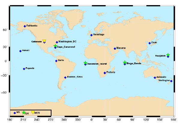
Today, there are 31 satellites in the GPS constellation. These satellites are controlled by a Master Control Station, MCS, located in Colorado Springs, Colo. In 1984, the MCS received data from a series of monitor stations situated at five locations around the world and three ground antenna stations located at Ascension Island, part of the British Overseas Territory of Saint Helena, Ascension and Tristan da Cunha; Diego Garcia, British Indian Ocean Territory; and Kwaj.
With 21st century modernization programs these numbers have grown to four ground antennas and 16 monitor stations. A monitor station, which is equipped with atomic clock standards and GPS receivers, can track up to 11 satellites at a time.
The monitor station "continuously collects GPS data for all satellites in view from their locations." Then twice-a-day they conduct performance checks collecting data or measurements on the exact altitude, position, speed and "overall health" of the satellites.
This data is assessed by the MCS to estimate each satellite's orbit and clock errors and to ensure that these remain within predefined acceptable limits. The control station uses this information to generate the navigation message for the satellite.
The ground antennas meanwhile track each satellite "from horizon to horizon." As necessary, they also provide or transmit the necessary corrections and navigation messages to specific satellites from the MCS. This uplink is performed through an S-band radio signal.
On Kwajalein in 1984, plans were on-going to support the new Phase II satellite placement scheduled to begin in 1986. Projections at that time called for two-dimensional coverage by late 1986 and three-dimensional coverage in 1988.
Social Sharing