HOHENFELS, Germany (Mar. 4, 2008) -- Rarely do plans come together so well.
Sgt. 1st Class Kevin Bardy, platoon sergeant for the Technical Headquarters Section of U.S. Army Europe's 18th Engineer Brigade wanted his 19 surveyors and construction designers ready for the missions they will take on when the unit deploys to Iraq later this year.
USAREUR's Joint Multinational Training Command and the U.S. Army Garrison Hohenfels wanted the ability to land unmanned aerial vehicles in their training area.
The brigade's Mission Rehearsal Exercise here last month provided the perfect opportunity for both to get what they wanted.
Teams of surveyors from the 18th rolled into the training area -- what Soldiers call "the "box" -- here one weekend, ready to measure and electronically catalog every rise, gully, depression and contour for the proposed addition to an existing runway.
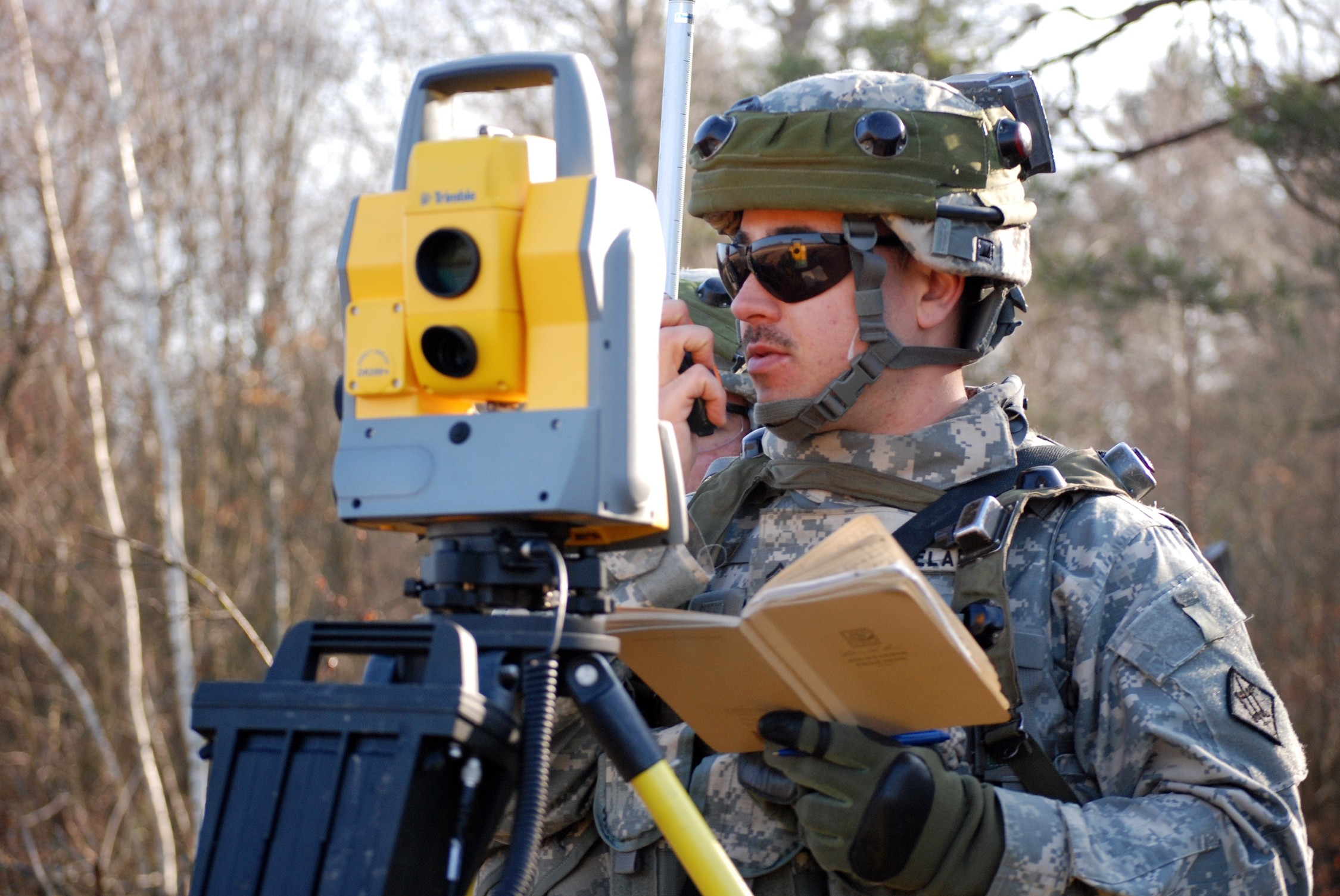
As a result, Sgt. Daniel Szambelan knew to the millimeter and the exact latitude and longitude where he was at about 10:30 a.m., Sunday, Feb. 24.
Szambelan and 10 Soldiers in two survey teams, joined by a GPS crew and a soil and asphalt study team, spent two days walking in 30-foot increments north to south and east to west across the 150-acre site.
In addition to their combat gear, the Heidelberg-based engineers came armed with the Trimble 5600 Total Station and the Trimble 5700 GPS Survey systems, commercial off-the-shelf devices recently added to the engineers' inventory.
The current runway is 5,400 feet long and garrison officials were considering extending it by another 1,000 feet, adding a taxiway and a hangar, Szambelan said while aiming the Trimble's infrared beam at "rod man" Pfc. Erik Lopez about 300 yards away.
"We'll get a bunch of topo (topographic) shots of the area and make a nice map of the area, so they have an idea of how much they need to cut and how much earthwork they will have to do," Szambelan said, now aiming at Spc. Randy Breeding at about 350 yards.
Although his tasks are sometimes tedious, the rod man is vital to the survey, Szambelan explained.
"He looks for things I can't see from here," he said. "From where he is at he can see all the high points and where we may have to worry about drainage or slopes or places where we'll have to do a lot of cut and fill."
While the rod men help capture most of the line-of-sight points, the GPS crews tackle the more challenging terrain.
"They can freely walk around and get all the elevations in the trees and in areas where it is harder to get into," Szambelan said.
During their two 12-hour days on the mission, the team "shot" more than 1,000 points, taking at least one "picture" per 80-square foot area -- sometimes more, depending on changes in elevations, or fewer on the site's flatter terrain.
Once the data is gathered, Szambelan's team returned to the brigade headquarters and uploaded their "points" into a computer. Their information will be combined with other survey and GPS data and used to create maps, designs and plans for the construction project.
"It will be on paper and in computer space, so they can get an idea of all the work they have ahead of them," he said.
Because of their pending deployment, the engineers will not be around for their next phases of the job: quality control and assisting the excavating and construction crews.
"When they start putting blades in the ground (excavating), we would be there with them," he said. "We would tell them where they cut too deeply or not enough."
While the GPS data showed Germany during the mission here, the engineers considered the task as working for Multinational Division - North -- the headquarters they will be assigned to in Iraq -- supporting brigade combat teams, Bardy said.
"In my mind it is MND-North; it's our division, our higher headquarters," he said. "It is not somebody here in Hohenfels. In Iraq, our 'customers' will be the BCTs or the Iraqi army."
Bardy said he wants to ensure his engineer technicians and topographic surveyors know their jobs and their equipment before they deploy.
Part of the Army's first modular engineer brigade headquarters and the first unit with the new structure to undergo a JMTC MRE, the Technical Headquarters Section has experienced a transformation of its own, he said.
"A year ago, I had five Soldiers. Now I have 19," Bardy said.
In Iraq the engineers will work with tactical and combat engineer units to conduct surveys, design construction projects, and assist with grading and earth-moving, Bardy added.
"We go out with the crews and we support the crews on the job site. Our guys are sliced out (attached) to the construction units," he said. "They do not just go out and come right back. In Iraq, I could send out the whole squad to support the (construction) battalions or companies."
Missions like the site survey and other skills lessons learned during the MRE are preparing the brigade for its missions in Iraq, said Col. Matthew Russell, the 18th's commander. The brigade will oversee three to five combat and construction engineer battalions in Iraq and will bolster the engineering capabilities of "Task Force Iron," as the MND-N units led by USAREUR's 1st Armored Division are called.
Those engineer battalions and companies will clear roads and build facilities for brigade combat teams and will help restore Iraq's infrastructure and train their Iraqi counterparts, Russell explained.
While they will be working for new customers, the Technical Headquarters Section will be familiar with one of its potential assignments and the tools they will use to do the job, he said.
"We are starting to assess a lot of the airfields down there," Russell said. "This type of equipment allows us to that more accurately and a lot quicker than we could in the past."
Social Sharing