1 / 3Show Caption +Hide Caption –
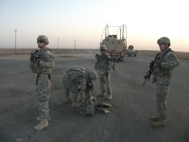
BASRAH, Iraq " Soldiers from Blue Platoon, C Company, 1st Battalion, 12th Cavalry Regiment, 3rd Advise and Assist Brigade, 1st Cavalry Division provide security while Spc. Fue Vang prepares an unmanned aerial vehicle for takeoff in Basrah, Iraq, Augu...
(Photo Credit: U.S. Army)VIEW ORIGINAL2 / 3Show Caption +Hide Caption –
BASRAH, Iraq " Soldiers from Blue Platoon, C Company, 1st Battalion, 12th Cavalry Regiment, 3rd Advise and Assist Brigade, 1st Cavalry Division, provide security while Spc. Fue Vang, an unmanned aerial vehicle pilot, prepares a bird for takeoff in Ba...
(Photo Credit: U.S. Army)VIEW ORIGINAL3 / 3Show Caption +Hide Caption – (Photo Credit: U.S. Army)VIEW ORIGINAL
BASRAH, Iraq -- To ensure the safety of their fellow comrades, surveillance teams often use ground or aerial imagery to track where friendly troops are located.
Soldiers from C Company, 1st Battalion, 12th Cavalry Regiment, 3rd Advise and Assist Brigade, 1st Cavalry Division deployed to Basrah, Iraq use both at the same time.
Using unmanned aerial vehicles and ground patrols, the unit has a 360-degree view of their area of responsibility.
While an unmanned aerial vehicle pilot prepares the eye in the sky for take-off, a platoon of Soldiers spreads out and keeps an eye on the surrounding area, allowing the pilot to focus on the UAV. Once in the air, the pilot uses the UAV to scan past the vigilant Soldier's line of sight.

Social Sharing