
Cleanup activities started on Lake Cochituate and continue into the summer for approximately 8 weeks, up to 6 days per week during daylight hours. Activities will include site preparation, mobilization, silt curtain installation, dredging, dewatering, water treatment, backfilling, monitoring, and site restoration. During the cleanup, boating access to and fishing within Pegan Cove will be restricted.
Cleanup Activities
The objective of the cleanup is to reduce the potential for human health risks associated with the sediment due to polychlorinated biphenyls (PCBs) in fish caught near the NSSC shoreline. The cleanup plan, selected by the Army with input from regulators and the public, will address PCB contamination of NSSC shoreline sediment in Pegan Cove. The Army selected the plan after completion of a Feasibility Study, which evaluated several possible risk management and cleanup alternatives. The cleanup is intended to reduce the average PCB concentration in sediment to less than 1 part per million (ppm) across Pegan Cove. This cleanup goal was selected because it is protective of humans who catch and eat native fish from the NSSC shoreline, is similar to existing PCB sediment concentrations observed at the higher-elevation Fisk Pond, and is consistent with goals selected at other PCB sites in New England. The cleanup action will reduce the volume and concentration of PCBs in sediment at the NSSC shoreline. The elevated levels of PCBs are likely related to an historic release from an electrical
transformer at the NSSC facility.
Lake Cochituate is transected by several major roadways and surrounded by highly developed residential, commercial, and industrial areas. Lake Cochituate is managed by the Massachusetts Department of Conservation and Recreation (MassDCR) and is used recreationally.
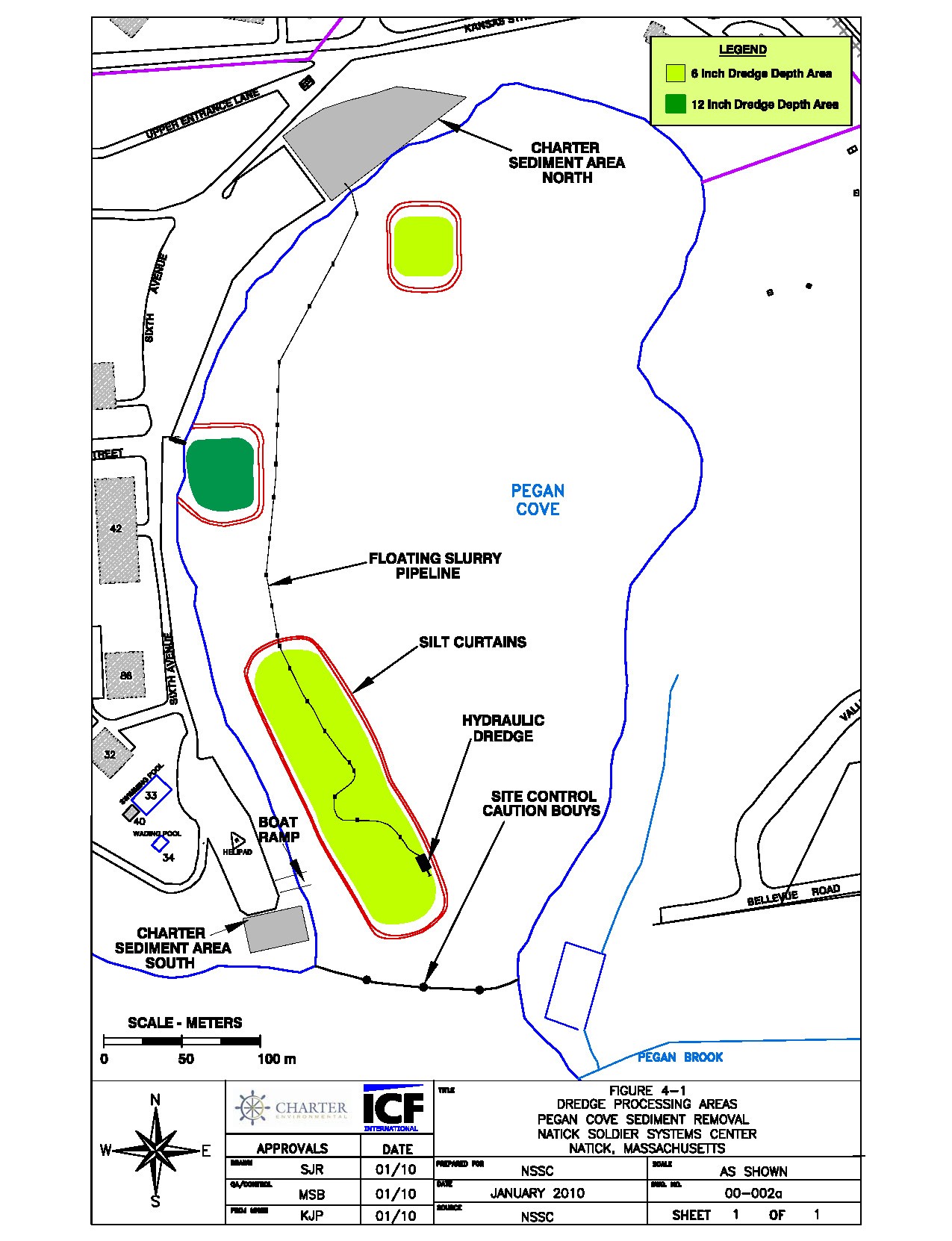
The selected cleanup plan involves the removal of PCB contaminated sediment using a hydraulic dredging technique from three "hot spot" areas within Pegan Cove. This technique basically vacuums the desired depth of sediment from the lake bottom.
Before cleanup activities begin, the Army will post signs on the NSSC security perimeter fence along Pegan Cove to limit boating in the area of the dredging activities and prohibit fishing within Pegan Cove during the cleanup action.
A hydraulic dredge will remove contaminated sediment from the lake bottom and convey it through a pipeline to a dewatering processing area consisting of a series of geotextile tubes, set up within open areas along the eastern shoreline of the NSSC facility. Water from the geotextile tubes will be collected and treated on-site with sand, fabric, and carbon filters. It must meet stringent water quality standards before being discharged back into the lake. Odor and dust will be monitored and controlled, as necessary.
Two silt curtains, which are barriers suspended from the top to the bottom of the lake, will protect lake water quality and stop the spread of milfoil outside the dredging areas by preventing their escape. Real-time monitoring at locations surrounding the dredging operation will ensure the effectiveness of the silt curtains.
Post-dredging sampling of each dredged area will be conducted to verify that the cleanup goals have been met. If necessary clean fill material will be used to backfill the dredged areas. Removed sediment will be tested to determine which type of licensed off-site disposal facility it will be transported to. At project completion, all equipment and materials will be removed from Pegan Cove and the NSSC property. Any onshore or shoreline areas that have been altered will be restored to their previous condition.
Site Investigations and Risk Assessments
The Army conducted human health and ecological risk assessments using data from numerous studies, with oversight by U.S. Environmental Protection Agency (U.S. EPA), the Massachusetts Department of Environmental Protection (MassDEP), the MassDCR, and the U.S. Fish and Wildlife Service. The risk assessments were completed in 2009 and indicate the following:
Aca,!Ac It is safe for adults and children to swim, wade, and boat along the Natick Labs shoreline.
Aca,!Ac Potential risks associated with eating native fish species (e.g., large mouth bass) caught near the Natick Labs shoreline within Pegan Cove are slightly greater than the U.S. EPA acceptable range. Since fish may take up contaminants from sediment, these estimated risks are the basis for the
Army's decision to clean up contaminated sediment.
Aca,!Ac Ecological risks due to contaminants from NSSC-associated sediment are negligible for bird and mammal species. Numerous other studies have been conducted on Lake Cochituate since the early 1990s. Detailed reports are available for public review in the Information Repository maintained at the Morse Institute Library in Natick. Additional information is also available at the US EPA web site:
www.epa.gov/region1/superfund/sites/naticklab
Social Sharing