Who determines route status in largescale combat operations (LSCO)? Is it the corps transportation officer (CTO), the corps engineers, or perhaps the protection team? In LSCO, determining the status of military routes is a complex and multifaceted process that extends far beyond the apparent simplicity of assigning this responsibility to a single entity such as the CTO, corps engineers, or the protection team. While it might initially seem that establishing route status falls solely under the transportation domain, the reality is far more intricate. To gain a comprehensive understanding of who determines route status, it is essential to delve into the mechanisms and collaborative processes that underpin this task. Unlike the simplistic view that assigns this responsibility to a single role, the determination of route status requires the integration of diverse expertise and input from various warfighting functions. Each of these warfighting components plays a critical role in ensuring that the logistical pathways essential for operational success are both secure and functional.
Route Status Analysis
Reflecting on my recent experience during the I Corps Command Post Exercise 2 (CPX 2), I realized that assessing and maintaining route status is a highly complex endeavor. The CTO oversees transportation logistics, and our role is complemented by the corps engineers, who assess and address terrain and environmental factors that may affect route viability. Additionally, the protection team provides assessments related to security threats and ensures that routes remain safe for troop and supply movements. Intelligence officers supply critical information regarding enemy activities and terrain challenges that inform route status. Logistics experts assess supply chain needs along the routes and ensure the efficient dissemination of all updates regarding route status across the command structure.
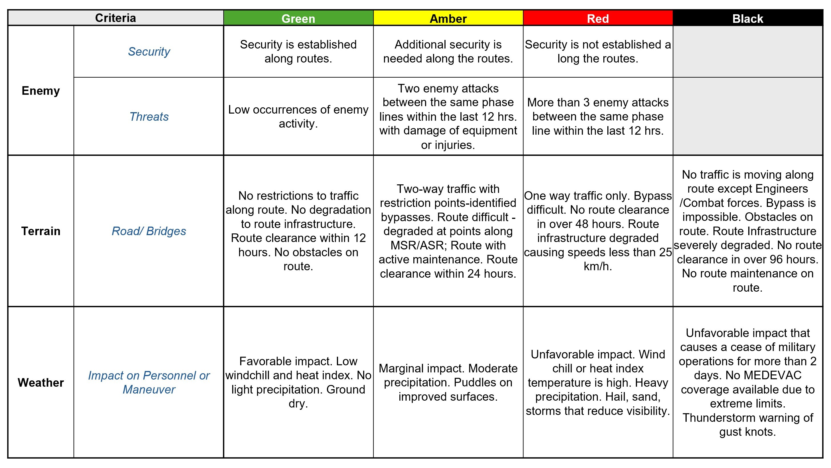
In LSCO, considering the massive area of operations (AO) and location, determining route status for every route can be even more difficult. One might ask how one determines route status for an entire route that you may never see. Is the route status red or green if the enemy is anywhere involved on any side of the route? This is a very good question. Subordinate units and analysis from various warfighting functions play critical roles in answering the question. We grasped this complex matter by implementing a few processes. In LSCO, we must establish checkpoints along routes to be successful. Checkpoints help establish route status on a smaller scale from multiple points inside one route. For instance, on one main supply route, checkpoint 1 to checkpoint 2 might be green, but checkpoint 4 to checkpoint 5 might be red based on enemy activity in the AO. Once the CTO receives the report, the CTO, corps engineers, and protection personnel determine which route to assess, but ultimately the decision stems from the operations channels. To help with determining whether a status qualifies as black, green, amber, or red, it makes sense for units to use some sort of route-status criteria chart.
We created our route-status criteria chart as a baseline tool that provides a means to send reports for corps to review and consolidate, and to get a full snapshot of the entire AO. At the corps level, the corps can only control what it can see from the corps support area (CSA) and below. Subordinate units must provide information for all routes beyond the CSA.
For route status to work, everyone must collaborate. The best way to involve everyone is through daily status reports, followed by a distribution working group (DWG) that reviews and synchronizes everyone’s reports from their respective AOs for one clear picture. The DWG may not resolve all issues, but it is a good meeting that incorporates all transportation and mobility operations across the corps from both subordinate units and enablers to help see the battlefield. The key to making the DWG and subsequent meetings work in relation to route status is having an operations presence available in each meeting to validate routes according to what is reported from each unit’s AO.
If the DWG cannot resolve routes, and warfighting functions cannot agree on the final outcome of a route, the decision must escalate to a higher authority and likely assessment at the protection working group (PWG) for subsequent resolution at the protection decision board (PDB) by the deputy commanding general (DCG) of protection. The PWG is crucial for gathering and consolidating feedback from each previously mentioned office of coordinating responsibility to suggest alterations to route status, which in turn affect travel requirements. With continuous protection monitoring throughout this process, the PDB can empower the DCG of protection to decide whether to close routes or designate them as black. Black routes halt travel and necessitate immediate action. In cases of significant issues on routes, operations might be conducted by engineers for repairs or by the maneuver enhancement brigade for clearance. Additionally, if the operation lacks a DCG of protection, then responsibility falls on the DCG of sustainment to make decisions at the sustainment decision board.
Final Thoughts and Considerations
In conclusion, our recent experience during CPX 2 and the Corps Warfighter Exercise highlighted that success in route status relied on making it a dynamic process and delivering real-time updates through the Maven Smart System (MSS). While there were opportunities for more in-depth discussions on route status, we found that the most effective approach was for battlespace owners to provide periodic updates on their routes based on their assessments from the route-status criteria chart and for the CSA Current Operations and Integration Cell to consistently update the MSS layer for real-time visibility. Additionally, we established a quick-action team, composed of representatives from each warfighting function, to address major events — such as downed bridges along routes from enemy attacks — without waiting for a formal meeting. Our DWG meeting focused on route validation, while the PDB was dedicated to route adjudication, determining the actions needed to return a route from black to amber or from red to green.
In the context of LSCO, determining the status of military routes is a complex and collaborative endeavor. This process demands the integration of knowledge and decision making from a wide range of military disciplines. Each discipline contributes its specialized expertise, reflecting the multifaceted nature of military operations. Recognizing this complexity unveils the intricate interplay of skills and coordination required to successfully support and sustain operations, especially in challenging environments where conditions can change rapidly.
The significance of route status extends throughout the duration of combat operations, influencing the movement and supply of troops and equipment. Therefore, it is necessary to consider route status meticulously and monitor it continuously, with heavy involvement from operational planners and support from enabling warfighting functions. The effective management of route status compiles the essence of collaboration, adaptability, and strategic awareness from all warfighting functions — not just one.
--------------------
MAJ Mikhail “MJ” Jackson serves as the corps transportation officer at I Corps (America’s First Corps). He previously served as the executive officer to the 7th Infantry Division commanding general. He has a Master of Science degree from Texas Christian University.
--------------------
This article was published in the spring 2025 issue of Army Sustainment.
RELATED LINKS
The Current issue of Army Sustainment in pdf format
Current Army Sustainment Online Articles
Connect with Army Sustainment on LinkedIn
Connect with Army Sustainment on Facebook
---------------------------------------------------------------------------------------------------------------
Social Sharing