*The garrison public affairs office translates information on local cultural events for the convenience of non-Italian speaking community members. The information contained in these slides is originally written by Italian news sources.*
**Information compiled by Laura Kreider/USAG Italy Public Affairs

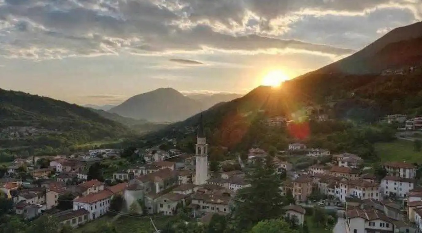
VICENZA area
Bacchiglione springs trail through forests, marshes and reeds – May 17, Il Giornale di Vicenza
The Bacchiglione springs offer a gentle loop trail through 27 hectares of wetlands, woods and spring‑fed channels between Dueville, Villaverla and Caldogno. Starting in Vivaro, the route follows embankments, dirt roads and wooded areas rich in wildlife, including migratory birds, fish and turtles. Part of the EU Natura 2000 network, the area preserves rare habitats and features fountains, basins and a birdwatching spot. The trail connects with two major long‑distance routes: the Fogazzaro Roi path and the path of the Apparitions. (Summary by Silvia Trevisan)
Caltrano’s alpine loop draws hikers year‑round – May 14, Il Giornale di Vicenza
The Giro delle Malghe in Caltrano offers an easy, panoramic loop ideal for hikers and families seeking a break from city life. The 14.7‑kilometer route, set between 1,223 and 1,389 meters on the Asiago Plateau’s southwest side, winds through open pastures, forests and historic mountain huts. The trail is accessible year‑round, with fall foliage and spring blooms providing standout scenery. Most huts operate from May to September, with Rifugio Bar Alpino serving as the main early‑season stop. The well‑marked paths and gentle elevation make the loop a popular choice for walkers, runners and cyclists. (Summary by Angela Balbo)
Historic “Cippi” trail in Enego reborn after storm Vaia – May 10, Il Giornale di Vicenza
The Cippi is a 30‑kilometer historical trail marking the 1752 border between Trentino and the Veneto with 29 ancient stones. Restored in 2023 after Storm Vaia, it begins in Frizzon, Enego, and follows Italian Alpine Club trail 869 across the Marcesina Plateau, passing huts, forests and key markers, such as the “Cardinale” stone and the Anepoz altar. The route can be divided into stages and offers varied terrain, scenic viewpoints and insights into centuries‑old territorial history. (Summary by Silvia Trevisan)
Hike from Priabona to Passo dello Zovo offers sweeping ridge views – May 3, Il Giornale di Vicenza
The route from Priabona follows the ridge of Monte Faedo to Passo dello Zovo, offering wide views of the Agno Valley and the Little Dolomites. The 14‑kilometer hike climbs from 253 to 614 meters and takes about four hours. The path passes hamlets, summit crosses, beech woods, old mule tracks and World War I defensive lines. Highlights include the Trinca, Madegona, Massignani and Bassani crosses, along with panoramic clearings. From Zovo, the route leads back along the same trail to Priabona. (Summary by Silvia Trevisan)
Creazzo on foot: broccolo fiolaro fields, hilltop views and hidden heritage – April 12, Il Giornale di Vicenza
The walk just outside Vicenza follows the gentle “Sentiero Broggiadoro,” a 4.5‑kilometer loop through Creazzo’s quiet hills and rural scenery. The route passes through ancient washhouses, a monastery, the rebuilt Rivella church and offers viewpoints stretching from Vicenza to the distant peaks of Monte Grappa and Pasubio. The trail winds through farmhouses, terraces, hawthorn-lined paths and fields of broccolo fiolaro, a winter specialty of the area. After completing the circuit Trodo Bianco road and Broggiadoro Alto, you return to Rivella Park, where the walk began. (Summary by Silvia Trevisan)
Spring blooms transform Villa Rotonda’s historic woods – April 12, Il Giornale di Vicenza
The grounds of Villa Rotonda are entering a new chapter, as its restored woodland becomes a destination of its own. Thanks to a €2 million PNRR project completed last year, the 13,000‑square‑meter grove now flourishes with spring blooms, including tulips and a striking spread of wild narcissus. The estate’s renewed landscape features restored statues, revitalized terraces, and accessible paths offering fresh vantage points of Palladio’s masterpiece. (Summary by Angela Balbo)
From Lake Fimon to Villabalzana: a scenic loop through the Berici Hills – April 5, Il Giornale di Vicenza

The 13‑kilometer loop from Lake Fimon to Villabalzana offers a varied route through meadows, woods and historic “priare” (abandoned stone quarries located in hilly areas). Starting at the lake’s northern tip, the path climbs past the “pianezze” viewpoints and the Capiteo dee Piarde, then continues toward Mount San Fise and the Pianezze fountain. It descends to the Cadini di Pianezze before rising through mixed forests to Contrà Rappo and the outskirts of Villabalzana. Highlights include Cà Gaspari, Monte delle Rose and the church of San Nicola. The descent through old priare leads back to Lake Fimon for a final lakeside return. (Summary by Silvia Trevisan)
Fara Vicentino, two easy spring hikes through nature and history – March 22, Il Giornale di Vicenza
Early spring is an ideal time to explore the gentle trails around the Alto Vicentino, especially those in Fara, rich with scenery and history. The 6.5 km “Admire Fara” route winds between villas, streams, hilltops and the former home of sculptor Alessio Tasca. The 7.5 km “San Giorgio” trail leads through vineyards, woods and small hamlets, revealing views of the Chiavone Nero valley. Both routes offer an easy, immersive way to rediscover the landscape and villages of the area. (Summary by Silvia Trevisan)
Mussolente: four trails connect hills, mills and historic landmarks – March 15, Il Giornale di Vicenza
The Mussolente trails offer four scenic loops through woods, historic villas and rural paths. Most loops begin at Vittoria Park, where hikers can compare difficulty and highlights such as the 18th‑century Villa Alessi. Le Roste is a gentle six‑kilometer walk past Villa Alessi, the “Madonna dell’Acqua” sanctuary and the Volon stream. The slightly longer Volpere trail extends the experience through oak and chestnut woods before looping back on paved roads. Le Rorate is the toughest, covering 8.5 kilometers of hills, panoramic meadows, historic sites and dense woodland leading back to town. (Summary by Silvia Trevisan)
Walking from Gasparetta to Mount Soro to uncover Valmarana’s charm – March 1, IL Giornale di Vicenza
The circular “Gasparetta–Monte Soro” trail near Valmarana offers a two- to three-hour walk through the Berici Hills, passing vineyards, woods and historic rural paths. Along the descent into the Tramontana Valley, walkers encounter springs, fountains and panoramic views of nearby villages and the source of the Cordano stream. The climb toward Salve Regina and Mount Soro opens wide views of the Sanctuary of Mount Berico before the path leads back down through the forested slopes. The walk ends in Valmarana village, home to the 18th-century Villa Valmarana Morosini. (Summary by Silvia Trevisan)
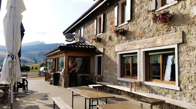
Plateau’s must‑visit mountain huts for great food and stunning views – February 25, VicenzaToday
The Altopiano offers scenic walks that end perfectly with local food and cozy mountain huts. The Larici da Alessio mountain hut provides panoramic views, historic charm and traditional Veneto-Trentino dishes. The Val Formica Refuge combines World War I–era trails with authentic alpine cuisine and a strong wine cellar. The Campomuletto Refuge serves simple, traditional meals — especially polenta — in a peaceful forest setting. Malga Col del Vento and Malga Roccolo highlight Cimbrian traditions, seasonal dishes and striking plateau views. (Summary by Silvia Trevisan)
Lusiana Conco, the Fontanelle trail between hamlets and springs – February 22, Il Giornale di Vicenza
The Fontanelle circular trail immerses hikers in centuries of mountain life, ecology and sustainable land use. Its eight‑kilometer route follows ancient mule tracks, wells, orchards and historic districts shaped by generations adapting to the karst plateau. The path winds through forests and small hamlets, offering accessible variations for walkers of all ages. On clear days, viewpoints reveal the foothills and even the distant Venetian lagoon. For a longer outing, the loop can be extended through Lastaro Valley before returning to Ciscati and Fontanelle. (Summary by Silvia Trevisan)
Intact WWI Austro‑Hungarian cave shelter discovered on Mount Asolone – February 19, Il Giornale di Vicenza
An Austro‑Hungarian shelter carved into the rock on Mount Asolone has been uncovered intact for the first time since October 1918. Sealed by collapses at the end of the Great War, the cave preserved weapons, grenades, gas masks, wooden structures and personal objects exactly as they were left during the final battles on the Grappa front. The excavation offers a rare, undisturbed snapshot of frontline life and the shifting positions between Italian and Austro‑Hungarian troops. The findings enrich conflict archaeology and highlight the need to protect fragile wartime heritage from dispersal and unauthorized recovery. (Summary by Anna Ciccotti)
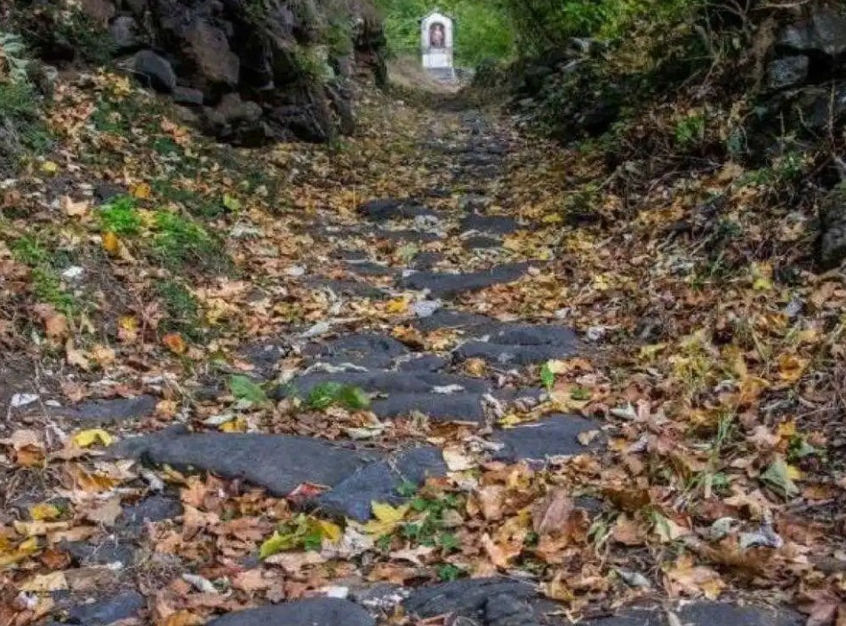
From Monte Berico to Chiampo, a Marian path of spirituality – February 8, Il Giornale di Vicenza
The Marian route from Monte Berico to Chiampo is highlighted during the 600th anniversary of the Vicenza apparitions, opened by Cardinal Pietro Parolin. It forms part of a larger pilgrimage from Vicenza to Pietralba. Chiampo features the ancient Madonna della Pieve and the Lourdes cave crafted in 1935 by Blessed Friar Claudio Granzotto. The path mixes rural stretches and minor roads, offering meaningful spiritual stops. It ends at Chiampo’s sanctuary complex, with its cave, church, botanical park and museum. (Summary by Silvia Trevisan)
Hidden garden will soon reopen in the heart of Vicenza – February 5, Il Giornale di Vicenza
This spring, the city will finally unveil the San Biagio Garden, a reclaimed green refuge hidden behind the former city jail’s high walls close to the Fogazzaro parking lot. The 1,340‑square‑meter space will offer new trees, play areas, a wheelchair‑accessible trampoline and potential design exhibits with the nearby university. A simple gate will replace the current metal door, opening the area to the public for the first time in 200 years. (Summary by Angela Balbo)
Sovizzo, a gentle escape through churches, villas and fountains – February 1, il Giornale di Vicenza

A 12-kilometer circular walk in Sovizzo leads through quiet countryside, ancient churches, villas and historic fountains. The path winds past landmarks including the Balabardo Bridge, Fontana Calda and the Lavei Fountain, with views over valleys and woods. It continues across the Sarolo plateaus and the village of Vigo, an area rich in Romanesque and Renaissance features. The return route passes through the villages of Vigo and Sovizzo Colle, offering views of nearby castles before looping back to the starting point. (Summary by Silvia Trevisan)
Novegno’s path of Remembrance through Great War sites – January 25, il Giornale di Vicenza

The Path of Remembrance is a demanding seven-hour loop on Mount Novegno that connects key World War I sites. Starting in Bosco di Tretto, the route climbs past former shelters, artillery positions and the Sailer observatory before reaching Priaforà and its wartime tunnels. It continues through Passo Campedello and Busa Novegno to Mount Forte Rione and the summit of Novegno, both marked by military remains of shelters and fortifications. The descent follows CAI trail 422 back to the starting point. (Summary by Silvia Trevisan)
Lugo, exploring Palladian villas through nature and countryside – January 18, il Giornale di Vicenza
Discover the Palladian villas of Lugo di Vicenza through several easy hiking routes that connect the villas of Lonedo — Villa Godi Malinverni and Villa Piovene Porto Godi — and lead through hilly landscapes, woods, small villages and a nature reserve. Many paths also reach the 15th-century Church of San Pietro on a volcanic hill, offering wide views of the plain. The routes can be combined in different directions, allowing hikers to explore nearby hamlets, the Selgea oasis and the scenic countryside surrounding the villas. (Summary by Silvia Trevisan)
Crespadoro, the rebirth of the ancient Visentina route – January 14, il Giornale di Vicenza
Durlo, a district of Crespadoro, is investing €500,000 to restore the ancient Visentina route, a 16-kilometer historic mountain trail once used between Tyrol and the Berico area. The project includes safety upgrades, redevelopment of Durlo Square and new sculptures, rest areas and a panoramic terrace aimed at boosting cultural tourism. Designed by architect Diego Morlin, the route is divided into sections from Crespadoro to Ala, Trento, following the natural terrain. (Summary by Silvia Trevisan)
Zovencedo, stone home reveals life inside the mountain – January 8, Il Giornale di Vicenza
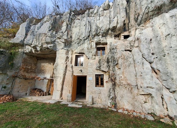
Zovencedo, a small town in the Berici Hills, preserves one of the Veneto’s most unusual historic homes: a stone dwelling carved directly into the mountain. Known as the Sengia dei Meoni, the site served quarry workers from the late 1800s through the mid‑20th century before housing local families. Its last resident left in 1959 after lightning damaged the structure. Restored with European funds, the two‑story home now anchors a cultural and natural park that includes the Vicenza Stone Museum and a didactic forest. Mayor Stefania Marchesini says the town wants residents and visitors to rediscover this heritage. Guides and volunteers continue to promote the area’s quarrying history, visible in the hand‑cut ceilings and tools still on display. (Summary by Angela Balbo)
Exploring Breganze among hills and ancient villages– December 14, Il Giornale di Vicenza
In winter, when many paths are blocked by ice and snow, walkers turn to the easier trails of Alto Vicentino. Breganze offers several scenic routes rich in history and landscape. The first easy hilly route, stretching about 5.5 kilometers, is a path through the former town of Riva. The Degani Trail, a 3.5‑kilometer path, meanders through hills and offers sweeping panoramas, including Santa Lucia hill. Finally, the longer trail from Breganze to Maragnole and Mirabella extends for 13 kilometers, a countryside route linking hamlets, featuring the 15th‑century Vegra shrine. (Summary by Silvia Trevisan)
Hiking Civillina to Campogrosso, discovering the secrets of historic districts – December 7, Il Giornale di Vicenza
A challenging 16-kilometer hike with an elevation gain of 1,166 meters takes about four hours each way from Mount Civillina to Campogrosso, passing through the historic districts of Recoaro. The trailhead is reached by driving to Bonomini di San Quirico in Valdagno, then continuing toward Rovegliana and Retassene. The return follows the same route, so consider arranging a car for convenience. (Summary by Silvia Trevisan)
The Blessed Claudio path between Treviso and Vicenza – November 23, Il Giornale di Vicenza

The Blessed Claudio Path is a 189‑kilometer spiritual and cultural route linking 25 municipalities from Santa Lucia di Piave to Chiampo, honoring the life and mission of Blessed Claudio. Inaugurated in 2018, the trail winds through the provinces of Treviso and Vicenza along peaceful secondary roads, inviting pilgrims and travelers to explore the Veneto foothills on foot or by bike. Created by the municipalities of Chiampo and Santa Lucia, the project promotes sustainable tourism and culminates at the Chiampo sanctuary, the spiritual heart of the journey. (Summary by Silvia Trevisan)
Recoaro Terme to Mount Cornetto: a journey through military tunnels and scenic views – September 14, Il Giornale di Vicenza

These are the last weekends of the season to tackle the equipped trail before conditions become less favorable. The route is safely accessible from June through October, offering a rewarding alpine experience for those prepared. While the hike isn’t technically demanding, it does require full attention, especially on the descent from Cornetto Pass to the summit. The trail traces an old wartime path, weaving through numerous tunnels with unstable terrain, so packing a headlamp and telescopic trekking poles is highly recommended. Begin your ascent from Campogrosso pass, following the trail via Onari pass. Park at Giuriolo Campogrosso refuge, accessible from Recoaro Terme, and set out on a 4.5-hour loop. The route is 11 kilometers long and climbs from an altitude of 1,448 meters to 1,899 meters when you reach the cross at Cornetto’s summit. (Summary by Silvia Trevisan)
Lake Fimon, a walk in nature just outside Vicenza – August 18, VicenzaToday
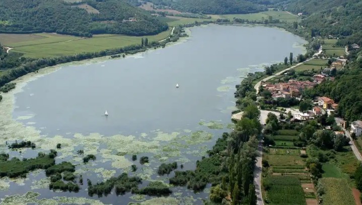
Lake Fimon is one of the oldest lakes in Italy, dating back to the Neozoic Era. Humans have chosen it since the dawn of time as a place to live. In Roman times, villas stood here, organized as farms, awarded to brave soldiers or as guesthouses. This romantic body of water is nestled among the green hills of the Berici Hills in the town of Arcugnano. It can be explored via a circular route suitable for everyone, on a dirt road closed to traffic. The walk takes a couple of hours at a leisurely pace. It’s a marvelous lakeside setting where you can enjoy the chirping of crickets and frogs, as well as many colors; scents; flowers; reeds; water lilies and even a pair of swans. It’s very close to Vicenza, so it can get crowded, especially on Sunday afternoons. If you love solitude, go on weekdays out of season. (Summary by Angela Balbo)
Lake Fimon’s ring trail made by Fidas volunteers – June 15, Il Giornale di Vicenza
Inaugurated in April, the Donor’s path new ring trail starts from Lake Fimon and joins the other seven hiking trails around Arcugnano. It was made by Fidas volunteers, who took care of cleaning and signage. The path winds for about 10 kilometers, with a maximum difference in altitude of 150 meters. Simple and suitable for everyone, the entire walk takes about four hours, it starts from the kiosk on the shore of the lake and passes almost entirely through ancient local roads. In addition to the scenic beauty, the path offers historical views and evidence of the past. The Corìo spring, for example, was a place frequented by the sick for its supposed healing properties. Today, its water flows at the foot of two large poplars, immersed in the tranquility of the woods. (Summary by Angela Balbo)
New cycle path coming soon along Bacchiglione River – June 9, Il Giornale di Vicenza

Vicenza is set to enhance its cycling infrastructure with a new cycle path along the Bacchiglione River, connecting Bassano Park to Piazza Matteotti. The first section, leading toward the stadium, is nearly complete, while a second 380-meter stretch, including a new footbridge, will be unveiled in the coming months. The project, funded with €875,000, integrates with existing cycle and pedestrian routes, allowing smoother access to the university, stadium and Bassano car park. Mayor Giacomo Possamai and Councilor Cristiano Spiller have highlighted the initiative as a strategic intervention for urban mobility, ensuring better accessibility and sustainability. Work, which began in September 2024, includes ramp demolitions and temporary closures as the infrastructure is completed. (Summary by Anna Ciccotti)
Monte Berico, a stele dedicated to the Madonna marks new path among Sanctuaries – March 28, Il Giornale di Vicenza

The Cammino delle Apparizioni (Path of Apparitions) is a walking path that crosses the provinces of Vicenza and Trento and connects five Marian sanctuaries where apparitions of the Virgin Mary occurred from the 15th to the 18th century. On Saturday, March 29, a new section of the path from Lonigo to Monte Berico will be inaugurated: pilgrims can walk on the path and reach Monte Berico, where a stele will be unveiled next to the penitentiary outside the Sanctuary. The stele in local red marble bears the inscription: Santa Maria di Monte Berico. Città di Vicenza. Cammino delle apparizioni” and the iconic sculpture of the Madonna di Monte Berico in white Vicenza stone is set in the niche. Similar steles will also be placed outside the other sanctuaries that make up the path. (Summary by Angela Balbo)
Marostica, the wall path between the two castles re-opens for spring – March 24, VicenzaToday

The path between the two castles of Marostica is open from March to November, every Sunday and public holiday. Easily accessible, it leads to the upper part of Marostica. It starts from the Church of the Carmini, then takes the Monte Pausolino path through a large and shady olive grove, which leads to the Upper Castle. Built in 1372, the city walls embrace the flat residential part of Marostica and then climb up the rocky slopes towards the Upper Castle in a succession of crenellated curtain walls joined together by towers, constituting a single fortified complex connecting the Lower Castle and the Upper Castle. Cammino della Ronda ticket prices are €5 for adults and €3 under 14 and groups. (Summary by Angela Balbo)
Porta dell’Acqua, a new gateway to downtown Vicenza – March 22, Il Giornale di Vicenza

Confcommercio Vicenza, an organization focused on revitalizing urban centers and supporting local economies, has proposed the construction of a new gateway to Vicenza called the “Porta dell'Acqua.” This initiative is part of a larger plan to promote the economic and tourist development of the city. The “Porta dell'Acqua” would connect the Fogazzaro parking lot to downtown Vicenza, transforming the area and making it more attractive to visitors and businesses. The “Porta dell'Acqua” project is expected to be completed within two years and could potentially help revitalize the Fogazzaro Parking area and boost economic activity in the city. (Summary by Silvia Trevisan)
Lonigo trail discovering ancient fountains while admiring nativity scenes – January 12, Il Giornale di Vicenza
The Fountains Trail in Lonigo is a 10.5-kilometer-long trail that shows historical and naturalistic features of Lonigo hills. Constructed by the local section of the Italian Alpine Club (CAI), the trail offers a gentle ascent of 210 meters, and it is suitable for all skill levels. Until the end of January, the trail is beautified with 27 nativity scenes created by Lonigo associations and residents of Monticello. The trail begins at the square where Friars Minor of San Daniele convent is located and continues toward Lonigo; along the way, hikers will come across various fountains. The trail is marked with signs, and it is recommended to follow a counterclockwise direction. Overall, the Fountain Trail provides an opportunity to enjoy both natural beauty and cultural heritage of Lonigo hills. (Summary by Silvia Trevisan)
City and hills get closer thanks to the urban paths, inauguration with walk on March 23 – March 1, 2025, Il Giornale di Vicenza

The municipality of Vicenza and the CAI (Italian Alpine Club) section of Vicenza have developed five circular routes to enhance the connection between the city and the hills by promoting knowledge of the area. The inauguration will be a large collective excursion with departure at 9 a.m. on Sunday, March 23. All citizens are invited to walk three of the urban paths together with CAI guides. It will be sufficient to show up at the meeting points: Piazza dei Signori for the Urban Trekking route (n.91), Piazzale della Vittoria for the Monte Berico route (n.92) and Parco del Retrone for the route that bears the same name (n.93). All routes are classified as easy. North of Vicenza, one can choose route n. 97 Nord Laghetto, which is free of architectural barriers, and the n. 99 Monte Crocetta, which starts from the church of San Giuseppe at Maddalene. The map of the municipal territory with the description of each route will be available to citizens and tourists at the URP in Palazzo Trissino, and at the IAT in Piazza Matteotti; it will also be published online on the municipality and CAI websites. (Summary by Angela Balbo)
Montecchio Maggiore, a dive into romance and history admiring the castles of Romeo and Juliet – May 27, Il Giornale di Vicenza

For a romantic walk, but also a dive into history and nature, you can choose to reach the castles of Romeo and Juliet in Montecchio Maggiore with a circular tour of just over five kilometers and a difference in altitude of about 200 meters that can be covered in two hours. You can park your car by the church of San Pietro and continue towards the small chapel where path number 1 starts. The terrace of Juliet’s Castle has a 360-degree view that on clear days reaches as far as the Piccole Dolomiti, the Berici hills and the Venice lagoon. From here, you can reach Romeo’s Castle along the main road and then return to the starting point. (Summary by Angela Balbo)
DURING SUMMER
Here’s where you can eat in a splendid mountain landscape
The Sette Comuni Plateau is dotted with cheese huts and rifugi, which in summer become ideal destinations for hikers, families and gourmets.
RIFUGIO LARICI DA ALESSIO – At 1658 meters above sea level, the starting point of numerous itineraries that can be explored both in summer and winter on foot, by mountain bike, with snowshoes and on mountaineering skis. The kitchen offers traditional dishes.
MALGA ROCCOLO – Surrounded by woods, meadows and lots of nature, it serves excellent platters of cured meat and cheeses, first courses, second courses of meat and delicious grilled meat.
MALGA COL DEL VENTO – A typical mountain restaurant, located near the pedestrian train road, which connects to the paths linked to the Great War and the English cemeteries.
RIFUGIO CAMPOMULETTO – A pearl set in the greenery of fir and beech trees. You can reach it comfortably by car: it is in Val Campomulo at Melette di Gallio. The cuisine is strictly family-style and rich in tradition.
MALGA STENFLE – Beautiful mountain cheese hut in the municipality of Gallio. Here, you can eat or have a coffee in a fabulous view. To the delight of children, there are many animals to play with.
RIFUGIO KUBELEK – In Cesuna di Roana, on the top of the historic Monte Zovetto, from here you can enjoy one of the most beautiful views of the plateau and of the seven bell towers of the villages. (Summary by Angela Balbo)
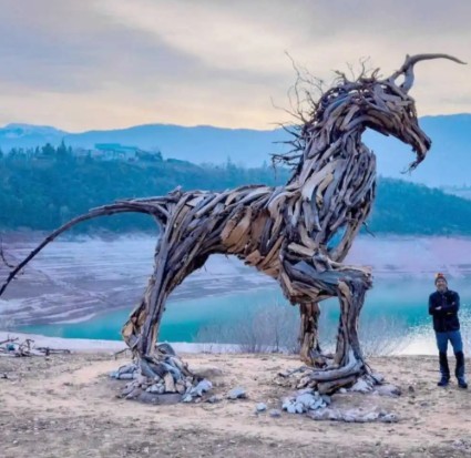
The world’s largest wooden winged lion watches over the Prosecco Hills – August 5, www.ildolomiti.it

Made from more than 3,000 pieces of tree roots felled by the Vaia storm, the latest work by local artist Martalar is the world’s largest wooden lion, standing over seven meters tall and 10 meters long. The historic symbol of Venetian identity is located near the village of Fratta, in the municipality of Tarzo, and it was commissioned by the Association for the Heritage of the Prosecco Hills of Conegliano and Valdobbiadene. Representatives and activists from the Green and Left Alliance attended the unveiling of the sculpture, peacefully protesting the placement in a protected natural site. (Summary by Angela Balbo)
The Deer of Fertazza, the new work by the artist Martalar – June 30, www.giornalealtopiano.it
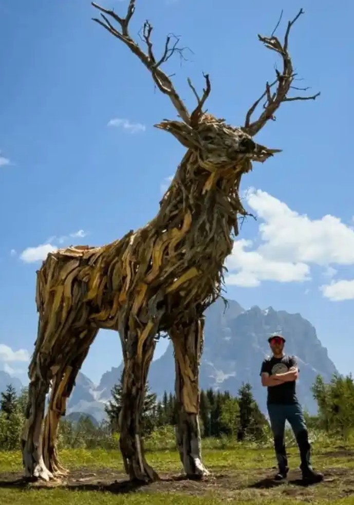
The latest work created by the sculptor from Mezzaselva di Roana Marco Martello Martalar is a deer. It is called the “Cervo del Fertazza” and is located in the Dolomites, between Civetta and Pelmo. The deer is sculpted in wood that fell during the Vaia storm at the end of October 2018. A work that is not just a sculpture, but a symbol of resilience and tenacity. The sculpture is seven meters tall and weighs about 1500 kilos. Made of 1,500 pieces of wood collected partly on the Plateau and partly on the Dolomites, it is Martalar’s work located at the highest altitude, 2100 meters. To reach it there are two options: a walk of about an hour starting from the Staulanza Pass, or the Pescul chairlift starting from Selva di Cadore. (Summary by Angela Balbo)
The wooden “Radicosaur” that re-emerges from the lake – March 23, Il Giornale di Vicenza
Seven meters long and five meters high, the “Radicosaur” appeared on the shores of Lake Santa Giustina, in the town of Predaia. It is the new creation of the artist Marco Martalar that joins the 11 sculptures he has already created using branches, roots and bark. All these works attract thousands of tourists. Famous is the Vaia Dragon in Lavarone, destroyed by arson, and then resurrected as the Vaia Dragon Regeneration created with the charred remains. The Radicosaur was created with roots collected from the shores of the lake, a creature that is part feline and part reptilian. It stands out from the other works for yet another stroke of genius by Martalar: thanks to where it is, depending on the seasons and the level of the lake, it will be partially submerged, resurfacing entirely like a magical being from legends. Entirely financed by the Municipality of Predaia, the new installation is part of a redevelopment plan for the Parco delle Plaze. (Summary by Angela Balbo)
Discover the Road of the 52 Tunnels in the Pasubio mountain – August 12, VicenzaToday

The Road of the 52 Tunnels is a classic mountain hike. Built in 1917 as a military mule track, it captivates with its bold design, the immense excavation work, and the spectacular views that open at every turn. The hike requires good mountain footwear and a flashlight for the darkest tunnels. It’s a challenging but extraordinarily scenic route. The starting point is Bocchetta Campiglia. Among panoramic views and evocative passages, you finally reach the final stretch, carved into the rock at an altitude of 2,000 meters, up to the Porte del Pasubio and the Rifugio Gen. Achille Papa. Before setting off, you can stop at the Rifugio Passo Xomo, while upon arrival the Rifugio Papa offers refreshments and memorable views. ***The route is open late spring/summer.
Discovering Mount Stomita among the secrets of “Omo della Rocia” in Cornedo – August 24, Il Giornale di Vicenza

The trail from Muzzolon, Cornedo hamlet, to the top of Mount Stomita is a 10-kilometer loop that offers historical and natural surprises. This moderately challenging hike takes approximately 3.5 hours to complete and features an elevation gain of over 500 meters. Starting in Muzzolon, after visiting the church dedicated to St. Mark the Evangelist, hikers follow the Brusà path to reach the summit, passing by the monolith “Omo della Rocia” and enjoying panoramic views of Agno Valley. The trail can be a bit challenging, especially as you approach the summit, so hikers should remain attentive and stick to the marked path, particularly during the final uphill section. Despite these challenges, this trail offers a great escape from the summer heat and a chance to explore the natural beauty of the area. (Summary by Silvia Trevisan)
Discover the suspended Tibetan bridge along an easy mountain hike with scenic views – August 18, VicenzaToday

The Anello di Campogrosso is one of the most picturesque loop hikes in the Little Dolomites. Easy and accessible to all, it’s approximately 12 km long with an elevation of 300 meters and takes about four hours to complete. The trail starts from the parking lot in Pian delle Fugazze (must pay for parking). Shortly afterward, you can make a short detour to visit the majestic Pasubio Ossuary, which houses the remains of over 2,000 fallen soldiers of the Great War. Continuing toward the Rifugio Campogrosso, the trail crosses the AVIS Suspension Bridge, a Tibetan bridge overlooking the Pasubio Valley. To return, you can retrace the same route or complete the loop on the opposite side, along the Strada delle Sette Fontane, walking through expanses of mountain pines. (Summary by Angela Balbo)
Sunflowers, the stars of summer – August 5, Il Giornale di Vicenza

The countryside between Vicenza, Costabissara, Caldogno and Monteviale offers expanses of yellow flowers silhouetted against the sky, attracting dozens of curious onlookers every day, armed with cameras, smartphones and sometimes even tripods. From Via Bachelet between San Pio X and Cà Balbi to Motta di Costabissara, passing through the side streets connecting Caldogno to Marola, the blooms abound. One of the most popular areas is near the cemetery in Motta di Costabissara. A note of caution: the land where sunflowers grow is almost always privately owned, cultivated for agricultural purposes (oil or seed production). Anyone wishing to approach for a photograph should do so with respect, avoiding entering the fields or trampling on the crops. (Summary by Angela Balbo)
Lusiana, path of love highlights nature, poetry and art – August 11, Il Giornale di Vicenza

Recently, the new “Path of Love” was inaugurated in Santa Caterina di Lusiana. The 5.5-kilometer-long path takes around two hours and follows old paths and mule tracks. In the rest areas and along the path, visitors will find poems by major international authors and art installations that explore the theme of love. The poems are accompanied by explanations, in both Italian and English, of the work and the poet. (Summary by Angela Balbo)
A hiking trail dedicated to St. Francis in Rotzo – August 8, Il Giornale di Vicenza

The new “Nature Trail of St. Francis” in Rotzo is dedicated to St. Francis, 800 years after the composition of the ‘Canticle of the Creatures.’ Along the trail, there are carved wooden panels inspired by the eight passages of the Canticle, as well as sculptures and educational panels with images of the local flora, fauna and history. The trail begins from the small church in Rotzo and extends in a loop for just over a kilometer, making it suitable for everyone. There is a panoramic rest point where the view extends from the Altopiano to the majestic Brenta Dolomites, adding to the already thrilling trail. (Summary by Angela Balbo)
Immerse yourself in the greenery thanks to Lustre summer tour in Tonezza del Cimone – August 3, Il Giornale di Vicenza

Summer is the best time to explore Tonezza plateau, offering scenic routes through meadows, forests and hamlets. Lustre tour trail stands out for its historical significance and natural beauty, described in ‘Tonezza e Fiorentini – Magical Plateau’ book. Starting from Pontara car park, the route leads through charming villages and past historical landmarks. The path takes you to a village with a unique public housing built after WWI, reminiscent of German structures. Continuing, you will encounter a steep and well-preserved mule track, historically used for cattle transit and sled descent. These highlights make Lustre tour an enriching and picturesque hike on Tonezza plateau. (Summary by Silvia Trevisan)
Montepian hike to discover Priabona and Vallugana jewels – June 29, Il Giornale di Vicenza

San Tomio di Malo hills and districts are a natural, historical, artistic and archaeological heritage of considerable interest. There are two different itineraries to discover the area, presented by the Municipality of Malo and described in the “Walking through our hills” guide. From Piazza Gen. Valerio Bassetto in San Tomio, where there is a detailed map, you can choose: the 11-kilometer scenic loop Montepian; the 16-kilometer “Creste” trail; the six-kilometer “Asini” trail and the 10.5-kilometer “Capitelli” trail, depending on the difficulty level and the available time you have. During the hike, you can admire a wide and beautiful landscape that embraces the Berici Hills and the plain, the Lessini and the hills of Agno Valley, the Littles Dolomites and the Veneto plain. (Summary by Silvia Trevisan)
Walking on Cogollo high trail among old quarters, meadows and forests – June 1, Il Giornale di Vicenza

Cogollo high trail is an easy hike at the entrance of Astico Valley leading to Sette Comuni plateau. It goes through old villages, meadows and forests over about six kilometers with a manageable elevation of 115 meters. The trail offers sun exposure in winter and shade in summer, suitable for both hiking and biking. The starting point is at the square in Mosson, by the oratory of San Gaetano. The trail, beginning at the end of Via San Gaetano, passes through historical sites like the former Rocchette Asiago railway route, built in 1910 and decommissioned in 1958. Along the way, hikers encounter remains of the ancient Lamaretto waterhole and the “Roman road.” The journey provides a glimpse into the region's history and natural beauty. (Summary by Silvia Trevisan)
Calvene and Caltrano waterfall park renewed, a new community space – May 28, Il Giornale di Vicenza

Associations, municipalities, schools, businesses and citizens have joined forces to restore and improve the Bosco delle Cascate (Waterfall Park), a scenic location between Calvene and Caltrano impacted by spring 2024 rains causing landslides and mudslides. The “Family woods” project, led by “Radicà” association and funded by “Cariverona” Institution with 116,000 euros, aims to revitalize the wood into a community park for well-being, cultural activities and social events. The project focuses on securing affected areas, enhancing existing beauty, addressing challenges and engaging the community in envisioning cultural and educational activities within the park. (Summary by Silvia Trevisan)
From Caltrano and Calvene to Alpine pastures plateau – May 11, Il Giornale di Vicenza
Several trails from Caltrano and Calvene lead to Alpine pastures on the Altopiano dei Sette Comuni. They are very popular in spring and summer for hiking, biking, horseback riding and mushroom picking. There are two itineraries to discover them, well described by Liverio Carollo’s hiking guide: one from Caltrano to Sunio and Foraoro, and another from Calvene to Serona and Fondi. Caltrano trail starts from Tezze, winding through a hornbeam forest and reaching an altitude of 900 meters before emerging into Grande Valley. For Foraoro Alpine pasture, the trail diverges towards living rock paths and hornbeam forests, eventually intersecting with the path from San Donato. These routes offer a picturesque and rewarding journey to the Alpine pastures above Caltrano and Calvene. (Summary by Silvia Trevisan)
The charm of Liona Valley among old caves, vineyards and sights – May 11, Il Giornale di Vicenza

This hike on the Berici Hills is suitable for all skill levels and in any season. It is about eight kilometers with a 250-meter elevation gain and it requires a three-hour walk. The route follows the CAI path 54, starting from Campolongo village, it offers beautiful views and historical sites like Villa Dolfin and the 15th century dovecote. Beginning at Piazza Saint Andrea, where you are welcomed by the beauty of a shrine dedicated to the Immaculate Heart of Mary, visitors can explore the medieval village. Continuing the path, hikers pass vineyards and Bertolaso house, then climb along the valley’s eastern side near Mount Cistorello. The route offers scenic views of San Germano, Villa del Ferro, Grancona parish church and the Vicentine Prealps. For additional information on the trail visit www.visitvalliona.it (Summary by Silvia Trevisan)
Discovering the Giusti Garden: a corner of wonder in the heart of Verona – April 20, Sgaialand

In Verona, a few steps from the historic center and the bustle of the Arena, lies one of the most fascinating Italian gardens in Europe, the Giusti Garden, which is a perfect example of an Italian Renaissance Garden created in 1580 by the Giusti family. Every corner offers a postcard-like view. Climbing up among terraces, stairways and old cypress trees, you reach the panoramic viewpoint. From here, Verona reveals itself in all its beauty. The garden is open all year round from 9 a.m. to 7 p.m., but it is recommended to check the official website for updated opening hours and any extraordinary closures. Tickets cost €13 per person, special prices for families at website https://giardinogiusti.com/opening/ (Summary by Angela Balbo)
From Rio Freddo Valley to Tonezza through Costalunga trail – May 4, il Giornale di Vicenza

Costalunga trail is an ancient route in Rio Freddo Valley, Posina, that leads to Tonezza plateau, historically used for trade and milling activities. This itinerary is particularly suitable during spring and summer seasons because the climate in this corner of the Vicenza Prealps is always cool. In the past, the route represented one of the main connecting routes between Tonezza and Arsiero, especially during Thursday markets. The trail was also used by woodcutters and coal workers, moving coal down the valley. During the Great War the upper part of the path was constantly controlled by Austrians. The two-hour itinerary, well described in Liverio Carollo’s hiking guide, starts from Contrà Polo but it is suggested to leave the car near Scattolari district. (Summary by Silvia Trevisan)
Strolling through many districts of Agno and Chiampo valleys – April 13, Il Giornale di Vicenza
A route suitable for all seasons can be planned by those who want to discover the many districts between Agno and Chiampo valleys. The route begins in front of Cerealto’s church and among meadows, woods and districts you can take a nice circular tour, suitable for mountain bikes, Nordic walking, but also for those who simply love walking in nature. Almost eight kilometers, which can be covered in about two and a half hours with an altitude difference of almost 300 meters. From Cerealto, you can enjoy panoramic views of Lessini Mountains, Venetian Pre-Alps, and, on clear days, even the Venice lagoon. (Summary by Silvia Trevisan)
A new route around Lago di Fimon – April 7, Il Giornale di Vicenza

The new “Donatore” hiking trail created by the Arcugnano group of FIDAS was inaugurated April 6, adding to the other seven routes in Arcugnano. The easy four-hour circular route starts from the lake refreshment point and extends for about 10 kilometers, with a maximum altitude difference of 150 meters. Along the trail you can admire the old fountains (Boeca, Grancare Alte, Palù and Pianezze Alto), two bridges over the Canal Nuovo (Guagnola and Palanche), the small oratory-church of the Gobbati dedicated to the Madonna delle Grazie in Contrà Colombara and cross the villages of Grancare Basse and Alte and the old church of Pianezze Alto. (Summary by Angela Balbo)
Among woods and streams to discover Buso del Bao trail in Castelvecchio – April 6, Il Giornale di Vicenza

Castelvecchio, a hillside hamlet in Valdagno, is a picturesque destination with a lot of history. The name, according to legend, could come from a castle built by the tyrant Ezzelino da Romano in the 13th century, which no longer exists. To reach the starting point of the hike, you must take the provincial road to Cerealto and Castelvecchio. The trail, known as Buso del Bao, begins near the fountain and offers a challenging but manageable walk of about 10 kilometers. Along the way, hikers will pass by the renovated Buso del Bao bridge and be surrounded by the lush vegetation of the gorge. The trail eventually leads to the district of Chiesa di Castelvecchio, and – from there – follows the main road until reaching a fork. The whole journey can be completed in about four hours. (Summary by Silvia Trevisan)
Pedemonte, the climb to Belvedere fort among forests and the World War I memories – March 30, Il Giornale di Vicenza

The ascent to Belvedere fort from Via Scalzeri offers a unique experience in a beautiful area on the Trentino border. The hike showcases stunning views and tells centuries of history with its ancient dry-stone walls and World War I outposts. The hike highlight is the fortress, which sits on a limestone rock and overlooks Val d’ Astico, the border between Italy and Austria-Hungary during World War I. The itinerary takes you along the main street towards Strada della Riva. Along the way, you will pass by Gorgo Santo waterfall, which widens between the rocks into a mirror green-crystalline pool. The trail is lined with historic dry-stone walls, highlighting its significance over the centuries and, especially in summertime, the fortress is a must-visit built by the Austro-Hungarian army between 1908 and 1912. (Summary by Silvia Trevisan)
Charming hike through the hills of Isola and Castelnovo – March 2, Il Giornale di Vicenza

The route between the hills of Castellaro and Guizza, spanning 12.5 kilometers with a 620-meter altitude difference, offers an easy hike to discover Isola Vicentina and Castelnovo. This trail features isolated districts, wooded areas and villages, providing wide views of terraced hills and the Piccole Dolomiti peaks. Key landmarks include the town hall, Santa Maria del Cengio convent, medieval castle remnants, and the Cogolla church. Starting in Piazza Marconi, the route crosses streams, passes historic sites like a 15th-century sanctuary and a former spinning mill, and winds through forests and meadows. Scenic panoramas of the Grappa massif and various peaks can be enjoyed along the way. The trail highlights volcanic rocks and various historic buildings, eventually leading back to Isola’s center. (Summary by Anna Ciccotti)
Brogliano, walking on an ancient volcano – March 16, Il Giornale di Vicenza

In the pristine nature of Brogliano you can walk on an ancient volcano and visit the architectural testimonies of the past. The three-and a half hour ring walk starts from the center of the town to reach the hamlet of Quargnenta. It is a route of about 12 kilometers, with dirt and asphalt road sections, relatively easy and with a difference in altitude of 300 meters. It starts from the historic center of Brogliano where there is the church dedicated to the bishop San Martino di Tours, an example of Gothic architecture and decorated with white and red geometric motifs, which dominates the heart of the town. Just outside the town center you can see the parish church of San Martino, the oldest sacred building in the valley. Then, the Bregonza hill of volcanic origin can be accessed starting from Contrada Finotti and Contrada San Martino with easy-to-follow paths, marked by signs of the Piccole Dolomiti ecotourism ring. The top of Mount Bregonza is a very quiet place surrounded by a few benches, ideal to stop for a moment and relax before continuing on your journey. (Summary by Angela Balbo)
Explore Mount Cimone, a hike through WWI History and natural beauty – March 9, Il Giornale di Vicenza

The Mount Cimone ossuary hike from Arsiero via the Sentiero degli Alpini offers a blend of historical significance and natural beauty. Built in 1909, the trail ascends through terraced fields, cobbled paths and dense forests, showcasing remnants of Italian military infrastructure from World War I. At the summit, a shrine commemorates 1,210 unknown Italian soldiers lost in a 1916 Austro-Hungarian mine explosion. Officially inaugurated in 1929, the ossuary honors their sacrifice. The panoramic view from the summit covers the Cimone ridge, Val d’Astico, the Asiago Plateau and the Pasubio massif. Hikers can descend via CAI trail 542 or an alternate route through Cima Neutra, offering further opportunities to explore military tunnels and historical landmarks. (Summary by Anna Ciccotti)
Lusiana Conco, discovering the ancient districts among Pedemontana hills – February 23, Il Giornale di Vicenza

The Lusiana Conco trail is a circular tour, 7.5 kilometers long and lasting approximately four hours. Starting at Laverda Road, the trail leads hikers through the ancient hamlets of Lusiana, allowing them to explore the foothills between Marostica and Breganze. The trail passes through Sasso; Perarola; Ponte; Lupiari and Laverda roads. The starting point is reached by driving along the provincial road that connects Mason Vicentino to Laverda, where parking is available. The trail runs along the left bank of Laverda stream, featuring large slabs of pink and white local stone. Overall, Lusiana Conco trail offers an easy and appealing hiking experience through the beautiful landscapes of the region. (Summary by Silvia Trevisan)
On the road between Lugo and Calvene in memory of partisan Silva – February 9, Il Giornale di Vicenza
“Silva’s Last Journey” is a historical excursion that takes place through Calvene and Lugo, exploring the sites associated to partisan commander Francesco Zaltron “Silva” and his Mazzini brigade. In collaboration with historian Liverio Carollo, the Silva Group of Mortisa and the “Friends of Thiene Resistance” have created a three-hour trail described in the book “Commander Silva: Daring and Sacrifice.” The route follows the paths that Silva took before being killed by the fascists in 1945. Starting at the cemetery of Calvene, the trail passes through various landmarks, including the village chapel of San Marco and the house of Silvano Testolin “Fifi,” one of the partisans who initiated the Resistance in Calvene. The itinerary provides a mix of historical context, natural beauty and a sense of civil pilgrimage as visitors navigate through the landscape. (Summary by Silvia Trevisan)
Discover Rotzo, the oldest village in the Asiago plateau – February 2, Il Giornale di Vicenza
You can discover the village of Rotzo with an easy walk. Starting from the parish church, take a small detour to the Romita Spring, named after a woman who lived here alone in a small house, earning her living by spinning hemp and working at the loom. Following the route parallel to the asphalt road that crosses the town, you will pass in front of the town hall and the cultural center, then take the Kaltgruuba road and up to the small church of Santa Margherita, the oldest Christian testimony of the area dating back to 1100. Behind the church, take the Magnaraut road up to the Laite di Sopra before descending into the hamlet of Castelletto. From here you can return to the town, encountering the archaeological museum of the Seven Municipalities which is worth a visit and then, opposite, the road that leads to the Rhaetian village of Bostel. You can also take the Wellebekh, the country road, which passes through potato fields and farms that bear witness to the thousand-year-old rural culture of the Seven Municipalities and leads to the municipal cemetery from where you return to the starting point. Along the route you will find maps and panels that explain the ancient local language. (Summary by Angela Balbo)
Vicenza, new cycle paths on the way – January 23, Il Giornale di Vicenza

The city has several projects underway to improve the safety of cyclists and pedestrians, and work is expected to start this year. An important one will be the connection between the Viale Fiume/Viale Trieste roundabout and the high schools near Viale Astichello: the stretch between the roundabout and Via Ragazzi del ’99 will significantly change with the closure of the northern access and a small square at the end of the street. Still in Viale Astichello, beyond Via Ragazzi del ’99 and up to the intersection with Via Baden Powell, the road level will be raised, and the speed limit will be 30 km/h. The Cà Balbi cycle path will connect to the one in Bertesinella through a parking area, and there will be a two-way cycle lane from the entrance to Via Brocchi to Viale della Pace. Work will also affect the last stretch of Viale della Pace towards Corso Padova, where the administration plans to make the underground crossing exclusively for cycle and pedestrian use, prohibiting access to cars. Finally, a cycle path will connect the area from the Maddalene Church to Via Fornace in Costabissara. (Summary by Angela Balbo)
Castelgomberto, discovering caves between churches and springs – January 26, Il Giornale di Vicenza

A walk to discover Castelgomberto is one of the ideal destinations for an excursion to the valley floor, especially when winter makes going out more difficult. The hilly town takes its name from a castle, nowadays in ruins. Around the year 1000, the municipality was known by the name of Chiuse, perhaps indicating the narrowest passage in the Agno valley, controlled by the castle. The suggested hacking route is about 10 kilometers long, with a 400-meter elevation gain, and consists of both dirt stretches and asphalt roads that are easily accessible. The walk can be completed in about two hours at a leisurely pace, depending on the stops you want to make along the way. The starting point is the forecourt of Barbaran palace, a Gothic fortress previously owned by the Trissino family. From there, the route continues uphill on Via Monte Mori. (Summary by Silvia Trevisan)
Discover Bocchetta Paù along the scenic loggers’ trail and historic paths – December 15, Il Giornale di Vicenza
The loggers’ trail to Bocchetta Paù is an easy and well-marked path connecting the base of Costo to the southern slope of the Altopiano dei Sette Comuni. Historically used by woodcutters, the trail (CAI path n. 671) starts at the town of Caltrano cemetery, winding through fields, meadows and forests. Notable features include the “Valdasa” fire-fighting reservoir, the capitol of Còstola and grazing deer. The final segment of the route, characterized by rocky crags and scenic views, leads to the pastures of Bocchetta Paù. An alternative, easier route starts from the Barricata tavern, featuring steep climbs, rock tunnels, and emplacements, ultimately converging at Bocchetta Paù. (Summary by Anna Ciccotti)
Discover Pedemonte’s beauty through the hike de la Riva – December 8, Il Giornale di Vicenza
The Strada de la Riva is a scenic seven-kilometer trail in Pedemonte that winds through four of the town’s eight traditional districts, or contrade. This trail, accessible year-round, offers unique views such as frozen waterfalls in winter and blooming trees in spring. Starting from Contrà Scalzeri, the path passes notable sites like the Pissavacca and Gorgo Santo waterfalls, rich with local legends, and continues through Contrada Ciechi and Brancafora, featuring historical sites and the parish church of Santa Maria Assunta. The trail concludes by returning to Contrà Scalzeri via the Astico cycle path. The route is well-documented by the cultural association Le Contrade, which also provides information on the local flora and fauna along the way. (Summary by Anna Ciccotti)
Historic villas and ancient churches along Bastie promenade – December 1, Il Giornale di Vicenza
Trissino hills offer a quiet and picturesque hiking destination with scenic, and historic villas to admire. The recommended itinerary is a loop tour that starts from the town center and is about eight kilometers long with a modest elevation gain. The walk takes you through rounded hills dotted with olive trees and vineyards, providing beautiful panoramic views. Convenient parking options are available near the town hall and schools, or in the square of St. Peter’s church. The suggested starting point is in front of the church, where you can follow various streets and paths that lead you up the slopes of the hill. Overall, this hike offers a peaceful and enjoyable experience for those seeking a serene outdoor adventure. In addition, behind the church of St. Andrew you can admire a reproduction of the cave of Our Lady of Lourdes, offering a beautiful view of the village and the valley. (Summary by Silvia Trevisan)
Marostica, walk to Pradipaldo to discover Gorghi Scuri Valley – November 24, Il Giornale di Vicenza
The Gorghi Scuri Valley, located in Pradipaldo village in Marostica, is a picturesque wetland filled with puddles, waterfalls and abundant wildlife. After parking at the large rest area near the sixth hairpin bend, visitors can walk back a short distance to “Da Tranquillo” diner, and then take the path to Gorghi Scuri, or Dark Gorges. There are three different paths available: the green path (4.10 km), the blue path (6.9 km) and the red path (11 km). The green trail in the Gorghi Scuri offers a picturesque hike with lush greenery and the sounds of a nearby watercourse. At “Nosellaro” junction, hikers have the option to continue the blue trail or the red trail. The blue trail descends to the valley, climbs up near the forest road, and skirts “Speroni” valley. The red trail, which is longer and more challenging, splits from the blue trail before Pozza district. It continues towards “Tortima”, where hikers can admire beautiful views. Both trails eventually meet again at “Nosellaro” junction, from where hikers can climb up to the destination. (Summary by Silvia Trevisan)
An easy walk in Laghi with its lake and pristine nature – November 3, Il Giornale di Vicenza
Here is an easy excursion particularly suitable in the fall, when the warm colors enliven the forest, and the mountains embrace the breathtaking landscapes. The starting point is from the center of Laghi, the smallest village in Veneto. After parking the car, follow a paved stretch that goes up to Contrà Ossati. Then, turn right and take Strada della Cenega, the ancient road, which enters a shady beech and hornbeam forest. From here you will reach Contrà Berta, set in the suggestive Cavallaro plateau; passing behind the houses, you arrive at the small church of San Valentino and then continue on the left along the paved road that reaches the Mogentale district. Passing the highest houses, take the path up to Contrà Xausa, located at the base of Mount Maio, where it crosses the CAI path 512 coming from Posina. At this point it is possible to make a detour and extend the route to climb to the summit. Those who are not interested can retrace their steps or continue towards Posina. (Summary by Angela Balbo)
Here are some of the mysterious places around Vicenza – October 26, VicenzaToday
Vicenza has a past made up of legends and mysterious stories, made even more evocative and atmospheric by the enchanting places where they take place. Here are three:
*The split mountain in Recoaro -- This mountain carved into the rock by the Torrazzo stream in the Piccole Dolomiti area of Recoaro Terme is mysteriously linked to female and aquatic creatures called “Anguane.” Locals say that when night falls, the anguane come out with their wicker baskets and wash clothes on the river. They are fascinating women with long hair, but with contrasting temperaments, sometimes docile, sometimes dangerous. They attract and enchant travelers with the excuse of accompanying them through the woods, then drag them into a deep hole and make them their prisoners forever.
*The gnomes in Asiago -- Coming from northern countries, after much wandering the gnomes discovered the silent woods of the Asiago plateau and now live here. If you pay attention, you can spot them as you enter the dense mountain forest, there are those who swear they have even spoken to them. They are 25 centimeters tall, good-natured and friendly, and love playing pranks on children.
*Devils and witches in Costozza -- The area of the Berici Hills between Lumignano and Costozza is characterized by a particular type of cave, called the “covolo.” They are real rooms carved into the rock with a sort of small door that serves as an entrance. Once upon a time, the inhabitants of the area took refuge inside them to escape enemy incursions during the wars. Legend has it that today there are arcane presences that could become dangerous for solitary visitors. Disturbing the dancing and wanderings of these witches is not a good thing, especially because they might get angry and scare you. (Summary by Angela Balbo)
Recoaro Terme, trek through enchanting forests along the Bear’s Path – October 27, Il Giornale di Vicenza
Recoaro Terme offers a scenic walk along the so-called Bear’s Path, leading to the discovery of the ‘Suntras’ and reaching the historic building called Casare Asnicar. The medium-difficulty trail spans four hours round trip with a 520-meter elevation gain. Starting from the town center, the route passes notable sites including the Giorgetti waterfall, Asnicar district and Contrada Ronchi. The trail leads through the Suntra forest, a unique open-air museum featuring wooden sculptures depicting fantastical creatures called ‘Suntras.’ The journey provides stunning views of the Little Dolomites, culminating at Casare Asnicar. The return route passes Malga Serita and other scenic points. This hike offers a great combination of exercise, beautiful nature, and a touch of local legend. (Summary by Anna Ciccotti)
Love the outdoors? Discover the Bregonze Hills – September 22, Il Giornale di Vicenza
More than 8,000 tourists visited the hills of Bregonze in 2023, a hilly area located at the mouth of the Astico Valley, bordered to the north and east by the Astico stream and sloping south towards the Vicenza plain. At the top there are rural villages and small towns, at the foot of the hill there are the municipalities of Zugliano, Carrè, Chiuppano and Lugo. The area includes elegant rural residences, places of worship, temples of industrial archaeology, sites of archaeological and historical interest, but also a network of paths, which make these hills an ideal destination for hikers and nature lovers. The site www.bregonze.it allows tourists to learn about the destinations as well as the various itineraries. (Summary by Angela Balbo)
Exploring the Brustolà Labyrinth, a hidden gem of the Asiago plateau – September 29, Il Giornale di Vicenza
Nestled in the heart of Gallio, Italy, the Brustolà Labyrinth offers a unique and challenging hiking adventure. This natural rock formation, carved into the karst rock of the Asiago Plateau, was once used by soldiers during the First World War. To embark on this two-kilometer adventure, start at the Campo-Muletto refuge and follow the road to Piazzale Lozze. The entrance to the labyrinth is a narrow passage located a few meters to the right of the CAI 850 path. As you venture deeper into the labyrinth, be prepared for a thrilling journey through narrow corridors, rock walls and a natural staircase. The ground can be slippery, so sturdy footwear is essential. Keep a watchful eye out for the blue markers that guide your way through the maze. Along the way, you’ll discover evidence of the Great War, including trenches and artifacts left behind by soldiers. The labyrinth also offers stunning views of the surrounding landscape and a sense of tranquility amidst the rugged terrain. For experienced hikers seeking a challenging and rewarding adventure, the Brustolà Labyrinth is a hidden gem worth exploring. (Summary by Anna Ciccotti)
Recoaro, hike to Santa Giuliana Hill offers escape to nature – September 21, Il Giornale di Vicenza
Strolling through the charming hamlets of Recoaro Terme offers an amazing opportunity to be surrounded by lush greenery. The starting point is from the center of Recoaro Terme, from the school parking lot behind the local parish church. Following a loop of approximately 11 kilometers, the hike can be completed in about four hours excluding stops. Hikers will be treated to breathtaking panoramic views of the Agno Valley, Recoaro, and the majestic Little Dolomites. Along the way, people can discover hidden gems like ancient mule tracks and the picturesque church of Santa Giuliana. The hike is perfect for the fall season and one can relax and soak in the peaceful atmosphere, perhaps enjoying a picnic or a refreshing drink at the summit. The return journey offers a different perspective while descending through the winding paths and lush forests. Keep an eye out for the distinctive landmarks that will guide you back to the starting point. (Summary by Anna Ciccotti)
Berici Hills, on the steps of the Templars and the Knights of Malta – September 8, Il Giornale di Vicenza
The San Donato Hermitage Trail 72 is an eight-kilometer hike in the Berici Hills, known for its historical significance and beautiful scenery. The trail starts from the parish church of Villaga and passes by the ancient villa called “La commenda di San Silvestro,” which was once the seat of the Templars and Knights of Malta. As the path continues, hikers will encounter the area of San Donato, where an ancient monastery and a small church can be found. The trail then descends towards Via Fagnin and crosses multiple junctions and woods. Upon reaching Mount Tondo, hikers can enjoy panoramic views of the surrounding area, including the Euganean Hills and, on clear days, the sea. Finally, the path descends the mountain slopes and returns to the plain, leading back to Villaga. The hermitage of San Donato can also be reached from Scudelletta in the municipality of Barbarano Mossano, offering an alternative route. Along this path, hikers can explore caves, rock ledges, and even a cliff for sport climbing. (Summary by Anna Ciccotti)
Recoaro Terme, discovering the Emerald basin around Gazza hill – August 25, Il Giornale di Vicenza
There is a beautiful walk in the upper Agno Valley, around Gazza hill where the renowned Cesare Battisti refuge is located. A quiet and easy itinerary, lasting about two and a half hours, to relax in front of the peaks of the Little Dolomites. The route is also well suited to lovers of the Nordic walking technique who will be able to enjoy splendid landscapes. Once you reach the car park along the Gazza Road, you can leave your car in “Vasca Obante” square. The climb to reach the top of the hill crossing the forest between small clearings and splendid views towards the Little Dolomites will not be difficult. When you reach a large clearing, you will see Alta Rove hut located at 1,180 meters above sea level and once you arrive at Gazza hill you are greeted by the remains of work from the Great War and educational panels indicating the “Open-air Museum in Vicenza Prealps.” Then, following the paved and downhill road of Gazza you will continue to descend quickly along the route until you find yourself on the mule track to return to the starting point. (Summary by Silvia Trevisan)
The old train road in Asiago is now a pedestrian and bike path – August 18, VicenzaToday
A walk suitable for everyone, even families with children and strollers, where the strong point is not the difference in altitude or the effort, but the amazing views that can be admired across the entire Asiago plateau. It is possible to park the car at the Asiago ice stadium, the departure is from the nearby old station. The path follows the course of the ancient railway that connected the Asiago plateau to the plain. It was inaugurated in 1910 and contributed to the growth of economic activities on the Asiago plateau until its closure in 1958. Today, it is a 20 km-long bicycle and pedestrian itinerary, with a slight difference in altitude of 250 meters and suitable for both bicycles and simple walks. After Canove, you enter a beautiful forest of spruce, white and pine trees and you notice how a part of the railway road has been dug into the rock, almost like a trench, now covered with plants and vegetation. Before arriving in Cesuna there is a railway toll booth, also evidence of the ancient railway. (Summary by Angela Balbo)
A walk around Lake Fimon following a circular route suitable for everyone – August 18, VicenzaToday
The complete tour of Lake Fimon is a pleasant walk in the greenery, also perfect for children. It is located in Arcugnano. The route is a ring of about five kilometers on a dirt road closed to traffic, the travel time in complete calm is a couple of hours immersed in a wonderful lake environment. If you prefer calm, avoid going there on Sunday. Lake Fimon is one of the oldest lakes in Italy, a rough estimate suggests that its succession could be more than 150,000 years old. Man has chosen it since the dawn of time as a suitable place to live: remains of animals, including tropical ones, from stilt settlements have been found in the surrounding peat bogs. (Summary by Angela Balbo)
From Campodalbero to Montefalcone along the refuge road – August 4, Il Giornale di Vicenza
Nestled between peaks, “Gingerino” refuge in Montefalcone Recoaro, evokes a futuristic vessel stranded on the mountains overlooking a boundless plain. Here, at 1,600 meters above sea level, the refuge overlooks the valleys of Agno, Chiampo and Verona, the Vicenza and Padua plains, up to Venice. To get to “Gingerino” refuge, it takes a couple of hours walking from Crespadoro area among nature, greenery and silence. There have been many finds from every era up there. Traces start from the Paleolithic, but also from the Romans; the Lombards; the Cimbrians of Bavaria; the Serenissima Republic, and in more recent history, the Great War and the Second World War. The walk can start from “Bertagnoli” refuge at Piatta di Crespadoro, at 1,250 meters, where you can take the road that goes up to the former quarry in about half an hour and from here you take the path that connects in half an hour to Mesole pass. There is also another route from Bertagnoli square along the old road built by the military engineers in World War I, and the flat road continues for another hour until Montefalcone refuge, an excellent refreshment point. (Summary by Silvia Trevisan)
The Serrai di Sottoguda canyon reopens to tourists six years after the devastating Vaia storm – August 1, Il Giornale di Vicenza
“It is a day of celebration for all our Dolomites, which in 2018 were devastated by the Vaia storm,” said the Veneto Region President Luca Zaia July 31 at reopening of the famous Serrai di Sottoguda canyon in Rocca Pietore, under the Marmolada, devastated by a storm six years ago. Approximately 13.2 million were invested to restore “a naturalistic jewel, a source of pride for the Veneto, which today we are returning to the community so that everyone can see with their own eyes how beautiful our mountain is.” The canyon route is a deep gorge just over two kilometers long and five to 20 meters wide, dug into the limestone rock by the erosion of the glaciers and the waters of the Pettorina stream, which descends from the Fedaia pass between vertical walls over 60 meters high. The Vaia storm had destroyed many of the 14 existing bridges, underground services, and long stretches of the route. Visits will be possible until Sept. 15 by reservation only, at the website www.serraipark.it/i-serrai/ (Summary by Angela Balbo)
The Altopiano di Tonezza offers two scenic hikes, perfect for summer – June 16, Il Giornale di Vicenza
The first hike is the Tour of the Contrade Alte (Upper Contrade). It is a seven-km loop starting from the Contra' Via parking lot. It winds through beech forests, meadows and historic sites like the Rossetta Cave and the ancient capital (built in 1427). The route offers views of the entire Tonezza area. The second hike is the tour of the Contrade Basse (Lower Contrade). It is another seven-km loop starting from the Contra' Via parking lot. This path explores the lower part of the village, showcasing dry-stone terracing, hornbeam and beech forests, and remnants of past agricultural activities. You'll also find scenic viewpoints towards Sette Comuni, Rotzo and Castelletto. (Summary by Anna Ciccotti)
Between Mount Corno and Mosca Peak on the French soldier’s trail – May 19, Il Giornale di Vicenza
Discover a lesser-known page of the Great War by retracing the steps of the “poilus,” the hairy ones as the French soldiers were called, almost all with beards and moustaches, sent to fight on the plateau alongside the Italians after the Battle of Caporetto. The area where the soldiers of the XII Army Corps were deployed is located between Mount Corno and Mosca Peak in the municipality of Lusiana Conco. The starting point is Bocchetta Granezza, equipped with a large parking space and reachable both from Lusiana and Asiago. From Bocchetta continue until the sign for the British cemetery, where there is a mule track that enters the woods that leads to a complex system of trenches and tunnels, which constituted the last Italian defensive line against the Austro-Hungarian army. Then, the path takes you back to the starting point but not before passing through a set of cracks, corridors and narrow passages. The trail develops along a gentle up and down in the woods for a total distance of approximately 8.5 kilometers. (Summary by Silvia Trevisan)
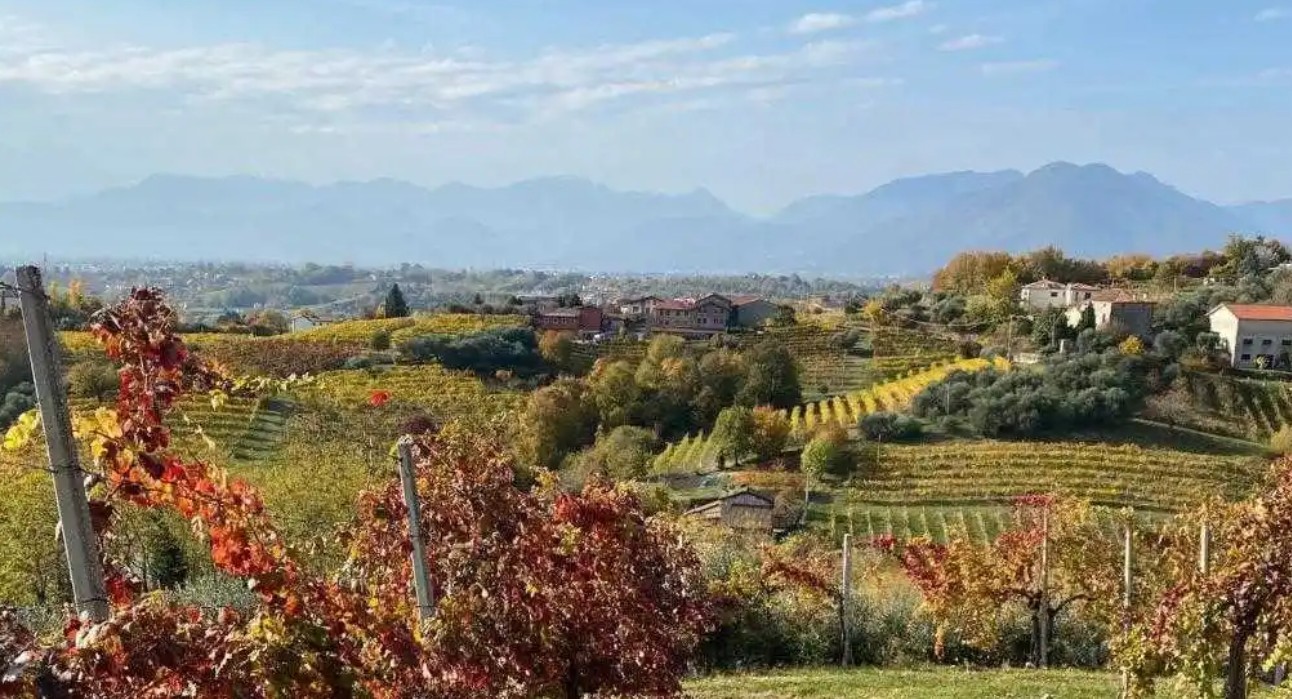
Six paths between Vicenza and Verona to discover nature, history, art and wine – April 15, Il Giornale di Vicenza
Ninety-five kilometers of marked paths, three valleys, six municipalities, but above all many variations of classic method bubbly wine to tell the story of a unique wine terroir. This is the “Walk of the Seven Volcanoes,” a wonderful itinerary made up of six paths and marked not only on maps and signs, but also with GPS tracking, which winds along secondary roads, mule tracks and paths. An opportunity to immerse yourself in geologically fascinating places at the foot of extinct volcanoes. It will be possible to retrace stretches that formed the backdrop to historical events of the last war, to then be catapulted into the world of fossil fish on a journey through time of 50 million years and admire the religious sculptures and columns dedicated to the nativity sculpted since 1600. Along the way, inhabited villages with places to sleep, eat or stock up on food and water. The distance between towns is never more than an hour and a half or two. Of course, this wandering on foot will take you to the vineyards and cellars of Durello and you will be able to taste the wines. For more detailed information check the Camminodeisettevulcani.it website. (Summary by Angela Balbo)
“Sette Roccoli” path among hunting lodges and ancient streets – April 14, Il Giornale di Vicenza
A walk that has its heart in “Sette Roccoli’ path. The departure point that follows the ridge between Valdagno, Schio and Monte di Malo is very variable given that the route passes through three municipalities. If you choose the longer route and leave the car at “Passo dello Zovo,” on the right of the restaurant you will take a slightly uphill path that runs alongside the dirt car park, where a sign reminds you that you are walking along the defensive line of the Great War which from Campogrosso ended at the entrenched camp of Vicenza. You can also decide to leave the car at “Passo del Mucchione” in the car park below the open space where the small church and the restaurant are located. Starting from “Mucchione” the first hunting lodge is the “Crocco” one, followed along the way by others always used in the past to capture birds to be used as live decoys in hunting. The return can be made through the same route or following the paved road. (Summary by Silvia Trevisan)
Walk along the patrol path of the Marostica Upper Castle – March 17, VicenzaToday
In 1372, the people of Marostica began building the city walls, a succession of crenellated walls joined together by towers constituting a single fortified complex connecting the Lower Castle and the Upper Castle. From March to November, every Sunday and public holiday you can walk along the patrol path. You start from the Church of Carmini where you take the path which leads to the Upper Castle. The Cammino di Ronda ticket price is €5 adult/€3 under 14 and groups. Cumulative ticket prices for Lower Castle + Cammino di Ronda are €11 adult/€8 under 14. Opening hours for spring and fall are 10 a.m. to 1 p.m. and 1:30 to 6 p.m. During summer, it is open from 10:30 a.m. to 1 p.m. and from 1:30 to 7 p.m. Last entry half an hour before closing. Times may vary based on weather conditions. To access it, visitors must be over one meter tall, not exceed 110 kg in weight and wear a light harness provided by the Pro Marostica Association. It is recommended to wear long pants, closed and comfortable shoes. For information, call the Pro Marostica Association at 0424-72127 (Summary by Angela Balbo)
Between districts up to Bocchese peak retracing the Great War – March 24, Il Giornale di Vicenza
A walk through the typical districts up to the cross on the steps of the Great War. The route to get to Bocchese peak requires little physical effort and can be undertaken starting from the village square, along the provincial road 246 towards Recoaro until the small path on the left that goes behind the houses. The slope soon becomes steeper, between vegetable gardens and terraces, until you pass a small hut on the left, after which the route becomes flatter. A final stretch of short hairpin climbing takes you to the summit where the large cross is located. Towards the south you can also identify the old cross which is located on a smaller tip of Bocchese peak among the limestone rocks. Right here passed the third line of resistance in 1918, which started from Mount Obante, it touched the Lora pass to bend towards Mount Spitz of Recoaro Terme and reach Bocchese peak to go down to Agno. (Summary by Silvia Trevisan)
Walk along the river Brenta in Bassano del Grappa – August 18, VicenzaToday
In Bassano del Grappa, the Ponte degli Alpini is the starting point of two pedestrian and cycle paths of great environmental beauty, which run along the left and right banks of the river Brenta respectively.
*Left bank—From the bridge (Angarano/west side) head north along the riverbank. Walking along Via Pusterla, go up to the hydroelectric power plant in Via Cà Erizzo. From here, there is a path immersed in the natural environment of the river. In just over half an hour’s walk you can reach the small, evocative church of San Bartolomeo.
*Right bank—From the bridge, start towards Via Volpato. At the entrance to the path there is a small natural beach with large boulders from the river that emerge when the water is low. Then you go towards the old Strada della Zuecca, cross the little bridge and arrive at Villa Bianchi Michiel. For those who do not want to retrace their steps, the return can be through Via Fontanelle. Once you are back at the Ponte degli Alpini, you can walk across it and head towards the Parco Ragazzi ‘99 for a quiet, refreshing break and discover the Giardino Parolini, an important botanical garden with rare and precious plants. (Summary by Angela Balbo)
Montegaldella, a healthy trail that pays tribute to the town of greetings – August 18, Il Giornale di Vicenza
Montegaldella, located on the border between the provinces of Vicenza and Padua is known as the “Paese del Saluto,” or the Village of Greetings. The village is home to a unique bicycle and pedestrian path called the Ciclabile del Saluto, or the Path of Greetings. This embankment path spans less than six kilometers and connects Ghizzole to Montegaldella and Cervarese S. Croce. The path is easily accessible by bike or on foot and intersects with other major bike paths in the area. Along the path, there are several posts that provide information about the history and meaning of greetings. The path also passes through picturesque landscapes, including an old embankment that separates the built-up area from the floodplain of the Bacchiglione River. The path offers a unique and enjoyable experience, serving as a reminder of the cultural significance of greetings and promoting a sense of community. (Summary by Anna Ciccotti)
From Montegaldella to Cologna Veneta by bike, new Vicenza section inaugurated – August 14, Il Giornale di Vicenza
A 29-kilometer section of the Treviso-Ostiglia cycle and pedestrian path, covering the entire Vicenza stretch from Montegaldella to Cologna Veneta, was recently inaugurated. It’s a great satisfaction for Sossano and the surrounding area, now crossed by one of the most beautiful cycle routes in Italy, which encourages sustainable mobility and is also an opportunity to discover the beauties of the territory. According to the Chamber of Commerce, the revenues linked to cycle tourism in Italy is around five and a half billion euros per year. After the blessing of the cycle path by Don Andrea Lupato, the authorities took a short tour on the cycle path, which “by 2025 will reach Ostiglia, completing the remaining 29 of the 118 kilometers of the route” as per Marco Taccini, president of the Veneto Strade that created the path. (Summary by Angela Balbo)
Social Sharing