

VIEW ORIGINAL

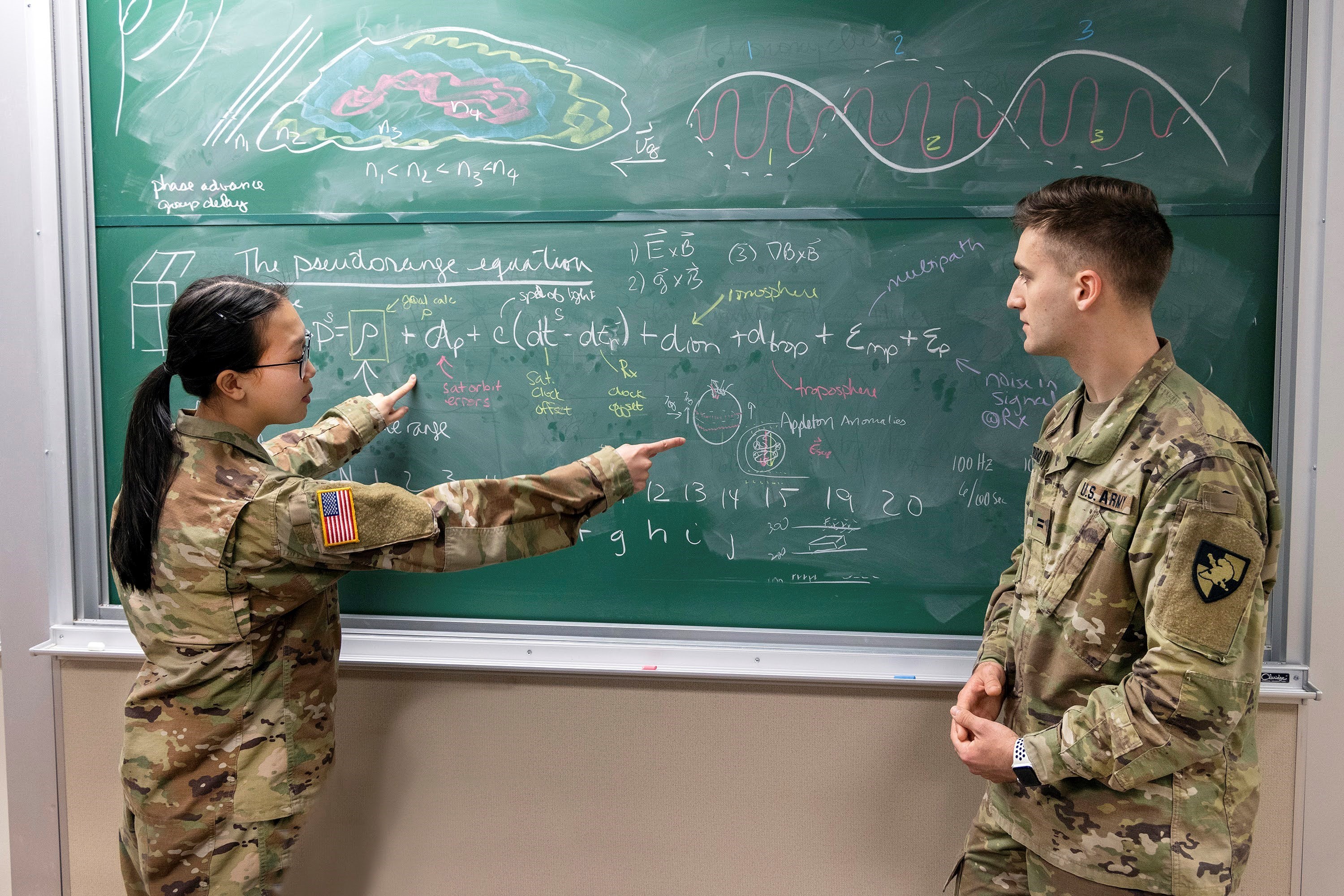
U.S. Military Academy cadets discuss how space weather impacts GPS signals, the physics behind these impacts, and the technology that it relies on, April 21, 2022 at West Point.
VIEW ORIGINAL

West Point, N.Y. - The Army--and the world--rely heavily on GPS data signals for its military operations and way of life. Critical to understanding how to protect and leverage GPS technology is space weather's impact on those GPS signals.
The team's research leverages data from the Illinois Institute of Technology's Space Weather Lab's high-resolution GPS data from the Arctic, and related upper atmospheric data collected by the Poker Flat Incoherent Scatter Radar (PFISR) located outside of Fairbanks, Alaska, to better understand how space weather impacts GPS signals, the physics behind these impacts, and technology.
The cadets on this interdisciplinary research team comprise four academic majors and two-year groups.
Isolating Confounding Variables Associated With Ionospheric Navigation Solution Parameters
The question of ionosphere scintillation and its effects on GPS functionality at high latitudes became increasingly pertinent with rising global temperatures and decreased sea ice in the Arctic Ocean. Through correlative analyses based on data gathered from the Illinois Institute of Technology, our team sought to increase modern understanding of ionosphere storms and how increased solar activity affects the precision of satellite-based navigation tools. This process began by collecting and managing large data files from multiple sources.
Afterward, the data was cleaned to a format ready for analysis. In order to isolate the effects of scintillation, manipulation was also necessary to account for the impact of other precision-harming processes, such as errors due to satellite configuration geometric dilution of precision (GDOP). Once appropriately cleaned and filtered, the data was then analyzed using models to identify where meaningful relationships do and do not exist.
Detection of high-latitude ionospheric plasma conditions leading to GPS scintillations using a novel PFISR Mode
The PFISR located in Fairbanks, Alaska, provides data on ionospheric conditions. PFISR detects plasma densities along the line of sight of conjunctive GPS signals in the E and F regions of the ionosphere through a novel model using five independent radar beams. This research project analyzes data collected on August 26, 2018, to show how plasma structures displace spatially and temporally. Cross-correlation methods in this study compare electron densities reported along each of five PFISR beams to detect when and where plasma structure patterns reoccur. Methods for isolating chaotic conditions within the ionosphere to quantitatively detect structures before disintegration and quantifying the correlation strength between beams are addressed.
Additionally, a three-dimensional approach to the visualization of plasma structure movement is explained. Initial results indicate that this analysis technique can successfully be applied across data spanning four Arctic winters. This study has the potential to quantify the shearing of plasma structures within the ionosphere and enhance the utility of ISRs in detecting GPS scintillation.
“Doing research with my team and Loucks has been beneficial in developing my ability to interpret information and turn it into meaningful deductions.” Cadet Dominic A. Rudakevych said. “When working with large datasets, most information will be unhelpful to the question you're trying to address. Quickly distinguishing important material from background noise and concisely summarizing this is a vital skill for officership,”
West Point's 23rd annual Projects Day will showcase more than 400 research projects by over 1,000 cadets! We welcome and celebrate the over 80 external partners and West Point faculty who contributed to these cadet-led projects. Follow along by signing up for the Projects Day App and learn more about the Academics at West Point.
About West Point
The U. S. Military Academy at West Point is a four-year, co-educational, federal, liberal arts college located 50 miles north of New York City. It was founded in 1802 as America's first college of engineering and continues today as the world’s premier leader-development institution, consistently ranked among top colleges in the country. Its mission remains constant—to educate, train, and inspire the Corps of Cadets so that each graduate is a commissioned leader of character committed to the values of Duty, Honor, Country and prepared for a career of professional excellence and service to the nation as an officer in the U. S. Army. For more information about the academy, go to www.westpoint.edu.
Social Sharing