
Prior to departing on a mission, Soldiers prepare by checking vehicles, weapons, radios and the weather forecast. The weather is integral to both ground and air operations, and Soldiers depend on cutting-edge technology to give them accurate and reliable information.
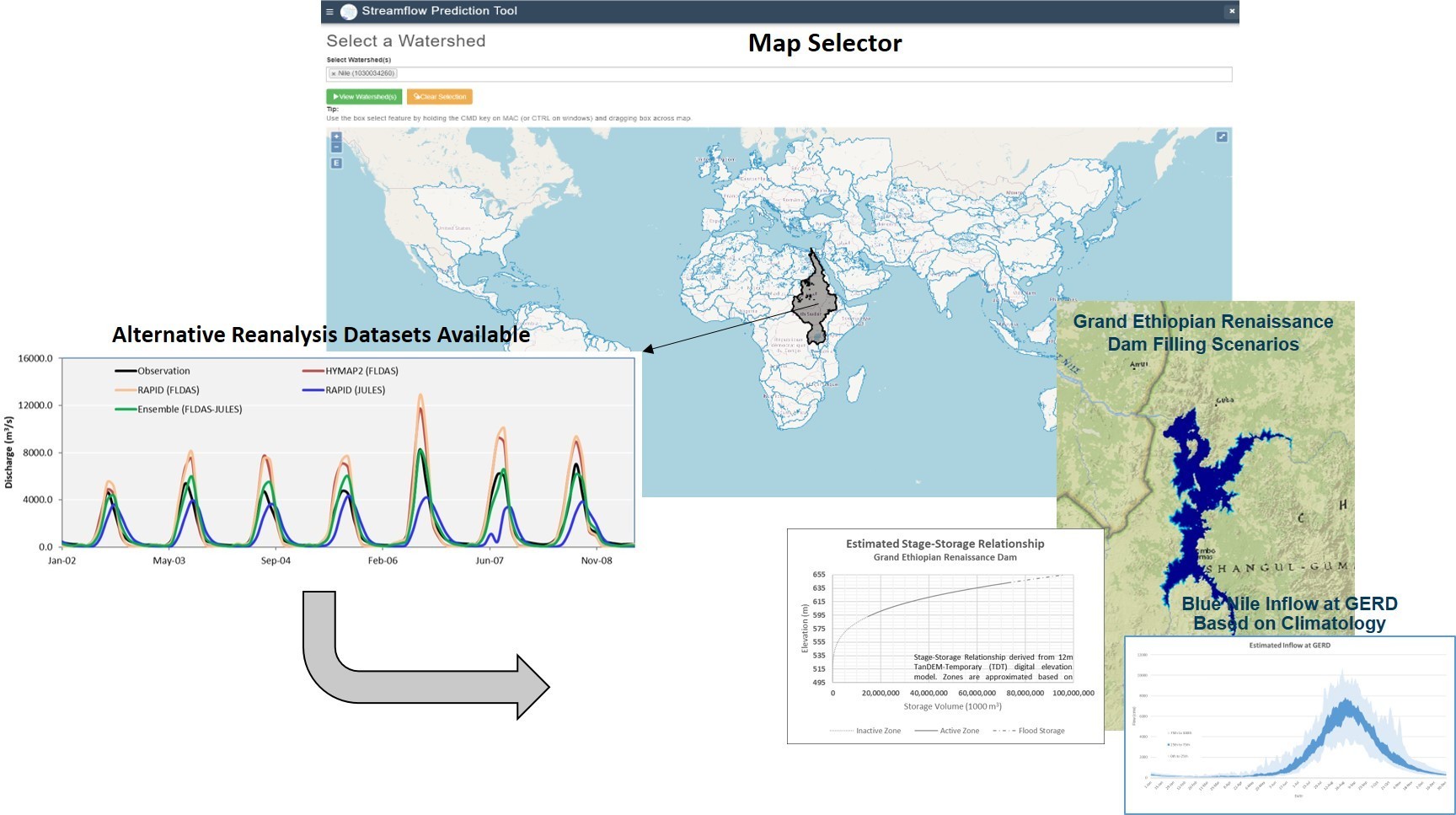
The Army uses Land Surface Models as the integral components of weather and hydrological models to transform weather events into flood events. A recent U.S. Army Foreign Technology (and Science) Assessment Support program project created a prototype that integrated a next generation LSM (HydroJULES) into the Engineering Research and Development Center Streamflow Prediction Tool framework. The ERDC-SPT uses authoritative U.S. Air Force weather forecasts that leverage several models developed in the United Kingdom to make real-time streamflow predictions. The ERDC-SPT is used by other services and organizations including the USAF, U.S. Marine Corps and intelligence agencies. The project blended multiple forecasting models to improve accuracy, reliability and multi-model ensembles.
“One of the key pieces of this project was aligning Army modeling with data from the United Kingdom so that we could provide real-time hydrologic forecasts to bridge operations and feed synthetic training environments. Synthetic training environments enable Soldiers to train in simulated multi-domain operations with actual and forecasted conditions,” said Dr. Mark Wahl, research civil engineer, ERDC Coastal and Hydraulics Laboratory, Wright Patterson Air Force Base, Ohio.
The U.S. Army Combat Capabilities Development Command FTAS program, USAF and NASA worked together to incorporate the U.K. JULES LSM with the Army’s ERDC-SPT. The advanced technology provides global streamflow predictions with locally precise flood mapping capabilities.
The team achieved several milestones, including collecting data from NASA and the U.S. Meteorological Office and developing baselines for existing models. The baseline information is used to evaluate performance of next generation models under development in the U.S. and U.K. and to evaluate enhancements to existing models.
Funding from the FTAS program also helped to facilitate a three-year project with the USAF and NASA to link current systems including the USAF Earth System Models with the ERDC-SPT for future integration at the USAF 557th Weather Wing. The USAF 557th Weather Wing is the lead operational meteorology center for the Air Force. The 557 delivers environmental situational awareness worldwide to the AF, Army, joint warfighter Unified Combatant Commands, national intelligence community and the Secretary of Defense.
As part of this effort, the USAF created a Hydrology Integrated Product Team, which included the USAF Weather Enterprise, NASA’s Hydrologic Sciences Laboratory, U.S. Army Corps of Engineers ERDC-CHL and Department of Energy Oak Ridge National Laboratory. The goal of the joint-agency integrated product team is to develop an operational hydrological system that provides global streamflow predictions with locally precise flood mapping capabilities.
“Due to the global coronavirus pandemic, we could not travel to the UK for the Hydro-JULES working group, which was challenging. We would have laid better groundwork for addressing deficiencies in relation to developing next generation models if we were able to meet in person, however, we achieved our mission of gathering the baseline analysis,” said Dr. Ahmad Tavakoly, research civil engineer, ERDC-CHL.
The ERDC-SPT prototype has transitioned to the ERDC military hydrology support team. The team anticipates upgrading the system with enhanced hydrography, reservoir simulations, flood mapping capabilities, and eventual support on NIPR, SIPR and Joint Worldwide Intelligence Communications System networks.
________
The Foreign Technology (and Science) Assessment Support Program creates opportunities for U.S. scientists and engineers to acquire and assess international technology. Through a competitive process, the FTAS Program will provide initial funds for Subject Matter Experts to perform technology assessments, basic research studies, and test and evaluation efforts of foreign Research and Technology that is deemed as unique, state-of-the-art, and has the potential to meet critical Army needs that are aligned with the Army’s modernization priorities for both the future and current force. Funding provided by the FTAS Program accelerates development of capabilities assessed at Technology Readiness Level 1-6.
Social Sharing