With winter weather always a concern in Missouri during November through March, travelers and commuters need to know the latest road conditions before hitting the highways.
The installation has various methods to keep Fort Leonard Wood employees and drivers informed of treacherous travel and weather-related information.
During winter weather conditions, the Maneuver Support Center of Excellence and Fort Leonard Wood Installation Operations Center coordinate snow and ice removal operations in order to ensure personnel safety and minimal impact to training and other missions, said Becky Haas, IOC chief.
Haas said the purpose of SNAIR is to keep everyone aware of current road conditions, manage removal of snow and ice and get the installation back to normal as soon as safely possible.
SNAIR is a cooperative effort between the installation's garrison directorates and mission/brigade assets facilitated by the IOC.
The IOC provides the compiled weather information to several venues where drivers can check road conditions before operating their vehicles.
Road conditions on post are broken down into color-coded definitions to quickly tell drivers what to expect as the weather changes. This information is available through a variety of means.
The Fort Leonard Wood official Facebook page: www.facebook.com/fortleonardwoodmissouri/ is typically updated the fastest regarding road conditions, facility closures or official announcements.
"The Fort Leonard Wood Weather Alerts page is updated at 5 a.m. every day (year-round) and as weather conditions change. It can be accessed from the Fort Leonard Wood home page or at www.wood.army.mil/snair/snair.pdf," Haas said.
By going to the Web page, drivers can access facility closures, current road conditions, status of primary parking lots and more.
The Wood Line is also updated daily at 5 a.m. and as weather conditions change, and the recorded message can be heard by calling 563.4141.
A new feature allows commuters to get the updated weather information pushed to them by way of their smartphone.
"The AtHoc program is our preferred method of publishing any severe weather related information," Haas said. Information on this feature can be found by clicking the "AtHoc Alerts Setup" hyperlink located at: www.wood.army.mil/newweb/weather.html. This feature is available to all CAC users on post as well as Family members, long-term contractors, private organizations or tenants on the installation.
In addition, several local radio and television stations in Lebanon, Rolla and St. Robert and Waynesville usually carry information on road conditions and post operations.
Another feature to help those commuting from areas outside Fort Leonard Wood is the Missouri Department of Transportation web page at, traveler.modot.org/map/.
Click on the Traveler Info Map and the icon for traffic cameras on the left of the webpage and then select an area on I-44 to view.
"If you go to the MODOT web page, they have cameras nearly all over the state so you can actually get a visual right outside Rolla, Lebanon, Waynesville and St. Robert, as well as road conditions statewide," Haas said.
While getting weather information out to the public is the IOC's main priority, they are also responsible for coordinating the clearing operations on Fort Leonard Wood.
Officials said every road on Fort Leonard Wood is mapped out and given a priority by the installation, and each SNAIR asset, such as TFW-TSAY, DPW, military units and others are given an area to clear.
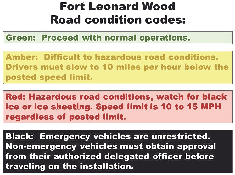
Road condition definitions
-- Green: No safety threat to the public due to weather conditions. Proceed with normal operations.
-- Amber: Difficult to hazardous road conditions. Drivers must slow to 10 mph below the posted speed limit to maintain traction and a safe stopping distance. Roads are icy or snow packed, but clearing operations are making roads passable.
-- Red: Most intersections present difficult or no stopping conditions. Weather forecast calls for continued precipitation with below freezing temperatures. Clearing operations have not kept priority number one roads easily passable. Black ice or ice sheeting has made passage hazardous. Safe speed limit is 10 to 15 mph regardless of posted limit, driving above 10 to 15 mph causes vehicles to lose traction and safe stopping distances are significantly increased.
-- Black: Restriction of all vehicular traffic on Fort Leonard Wood. Emergency vehicles are unrestricted (military police, ambulances, fire trucks, DPW, SNAIR support team mission essential vehicles). Non-emergency vehicles must obtain approval from their authorized delegated officer.
All recreational hunting will be prohibited during red or black road conditions.
Hunters should contact Range Operations at 573.596.0131, ext. 66147 or 62525 for the most current limitations during inclement weather.
(Editor's note: Becky Haas, Fort Leonard Wood Operations Center chief, contributed to this article.)
Related Links:
Maneuver Support Center of Excellence and Fort Leonard Wood Facebook
Social Sharing