FORT GEORGE G. MEADE, Md. (May 10, 2012) -- The closure on May 1 of the trail around the former golf course -- now known as the East Campus -- did not mark the end of the road for joggers and runners.
The Directorate of Family and Morale, Welfare and Recreation opened a revised jogging route on the same day.
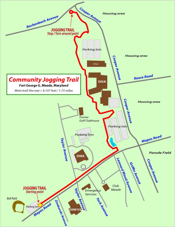
The mixed-surface course begins at the same starting point as the previous trail at the parking lot near the baseball diamond on Mapes Road near Zimborski Avenue. The revised course, which includes a portion of the previous trail from Mapes through the Defense Information Systems Agency, leads to a turn-around point near the intersection of Rockenbach Road and Cooper Avenue. The course is 1.75 miles each way.
This is not the first change to the once 3.1 mile trail, which originally formed a complete loop around the golf course.
In March 2008, approximately one mile of the trail was closed for the construction of DISA's campus, leaving behind a "C" shaped course. More than four years later, DISA's campus, which includes its own jogging trail, now forms a portion of the revised route.
DFMWR began to plan for a revised route in March. It accelerated the process in April when it was announced the golf course would close May 1, said Wendy Gibbs, chief of DFMWR community recreation.
"The installation is undergoing a lot of growth and transformation right now," said Gibbs. "Just like forming partnerships with Anne Arundel County for our golfers, we looked at all the options available, including working with DISA, and we believe this revised route will meet our community's needs."
One option involved using a utility access path that crosses Reece and Mapes roads as well as Llewellyn Avenue. The proposal was rejected, Gibbs said, because of safety concerns over joggers crossing the roadways.
In addition, safety remains a concern on the closed jogging trail, said Installation Safety Officer Kirk Fechter, who visited the site this week.
Despite signs and barriers posted at the entrance to the closed trail, unauthorized personnel, including joggers, have been spotted on the trail, which is part of an active construction site, Fechter said.
"We're just trying to keep them from risk," he said. "A construction area is high risk."
In an attempt to deter trespassing, the Directorate of Emergency Services has placed the area on special watch, said Lt. Col. Darrell Sides, director of the Directorate of Emergency Services.
Gibbs encourages individuals to use the revised route and other locations on post such as the almost one-mile trail around Burba Lake, the track at Mullins Field and the sidewalk around McGlachlin Parade Field.
While Gibbs admits the alternatives are less scenic than the previous trail, she believes Fort Meade remains fortunate.
"A lot of other installations don't have the land [for a trail]. ... [The revised route] is a good option for the people who want to be outdoors," she said.
Depending on finances and other projects, improvements to the trail may include placing better signage, widening the trail and laying more compressed gravel, said Gibbs.
Social Sharing