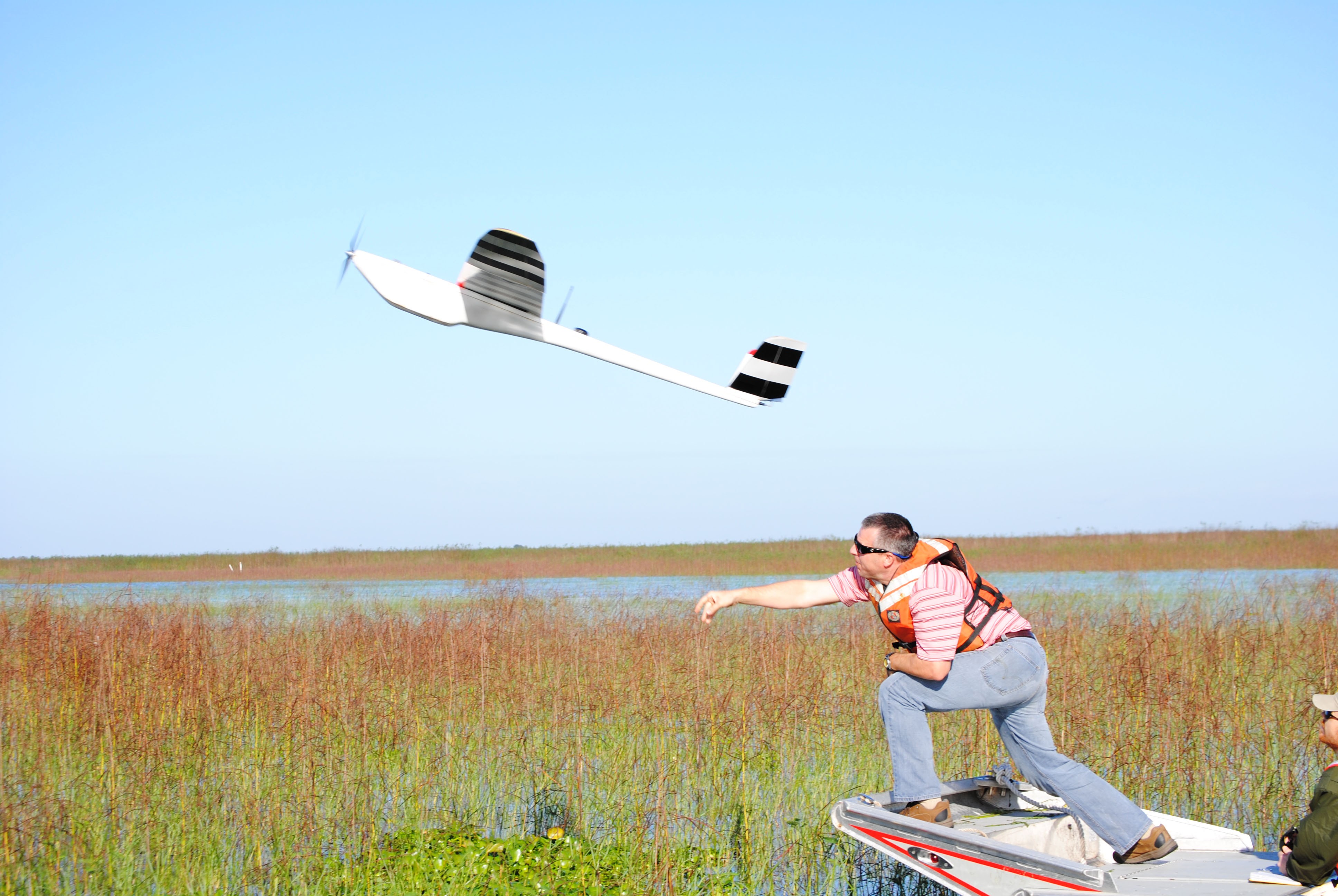
JACKSONVILLE, Fla. (Feb. 1, 2012) -- "All right guys, going into take-off mode. You are hot!"
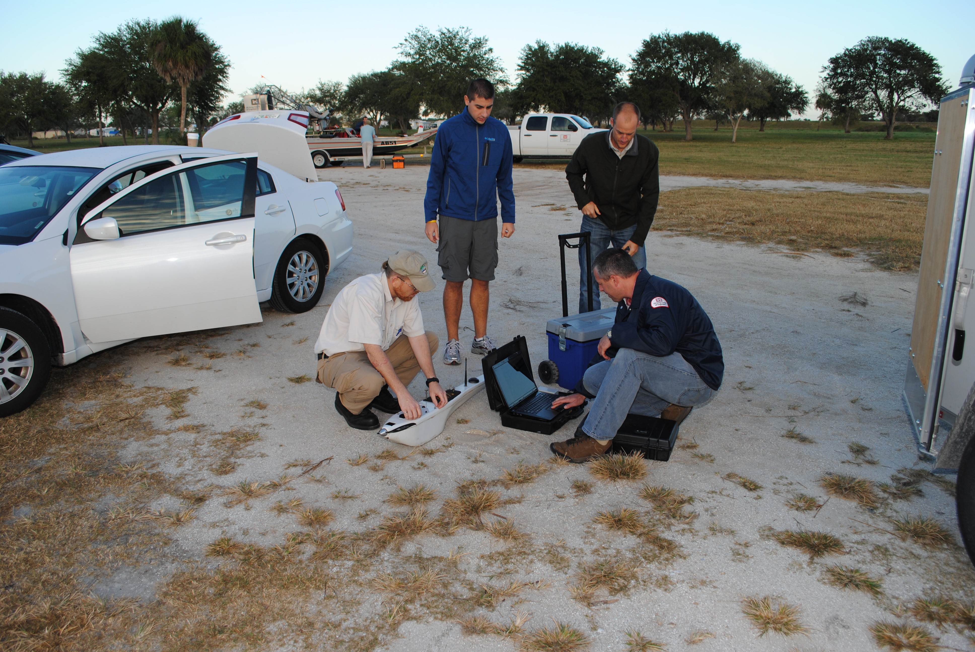
Everyone aboard the airboat grows quiet. It's the moment they've been anticipating after hours of preparation that started shortly after dawn on this late November day. Biologist Jon Morton has been leading the team through pre-operational checks.
"Three…two…one…launch!"
The pilot flips a switch on a remote control. Suddenly, the sound of a high-speed propeller fills the air around Eagle Bay at Lake Okeechobee. A small airplane that looks like a toy is thrown skyward. Only this airplane is no toy. It's an important piece of equipment that helps Morton and other biologists track the effectiveness of their efforts on invasive plants.
The NOVA Unmanned Aerial Vehicle offers the U.S. Army Corps of Engineers a low-cost method of obtaining pictures from the air for a wide variety of applications.
"The NOVA has been developed to provide a technological edge for us," said Larry Taylor, NOVA Unmanned Aerial Vehicle, or UAV, program manager. "Its specialty is detecting and monitoring change over time. We have used it for levee monitoring. We have detected anomalies in the levees that weren't detected by ground observation."
In addition to the levee monitoring the NOVA has also been used for wildlife surveys, regulatory permit reconnaissance, invasive species contract assessments and invasive species acreage estimation.
On this day, the NOVA is flying over hundreds of acres at Eagle Bay, gathering information for the invasive species management program.
"We do a lot of invasive aquatic plant work," said Morton, "Eagle Bay is one of the areas we have to manage more intensely and work with other agencies because this area is a high priority for the endangered Everglades Snail Kite. We wanted to get a snapshot view of what it looked like at this time of year."
The pilot smoothly guides the UAV upward. Morton checks a computer.
"Altitude 18, air speed 11, battery 18-6," he says, pleased that the aircraft is picking up speed and altitude.
Morton likes the detailed photography the UAV provides.
"We're trying to get two-and-a-half-centimeter resolution, which will allow us to map out and tell exactly what species of plants are growing in the area," Morton said. "Before the NOVA was available, we just had to take imagery that was obtained through U.S. Department of Agriculture, U.S. Geological Survey, or hire a private contractor."
"We didn't get nearly the resolution that we can with the NOVA," Morton said. "We're able to fly more rapidly. We're able to fly cheaper. We can deploy it from an airboat. We've used it from a swamp buggy. We can launch it from the back of a truck."
The NOVA makes a pass in the sky overhead. However, it quickly becomes a small speck as it flies toward its next turning point, more than a mile away from the controllers on the ground.
"Turning to the north," Morton says, "increasing the air speed to 16 meters per second."
The NOVA weighs 11 pounds, which includes its payload of a high-resolution camera, its on-board computer, and a global positioning system. The pilot uses a remote control to guide the plane during takeoff and landing. When in the air, the plane flies a route according to the instructions that were programmed on the ground station computer prior to takeoff.
"We're taking steps to use some of the technology that's available to us today, that people are only familiar with in military terms," said Morton. "This is an actual civilian application for unmanned systems."
"It's not a tactical tool," said Taylor. "It's not designed for the fighting Soldier to loft it and see if there are bad guys over the hill. The payload we carry is high-resolution, versus low-resolution, with on-board data storage because the mass of data that we gather cannot easily be transported in real time back to our ground station. It's more of a precision-mapping tool."
Development of the NOVA was a joint venture between the Corps of Engineers and aerospace engineers from the University of Florida. The NOVA is made of hybrid fiberglass and a carbon-fiber composite. Rechargeable lithium-polymer batteries supply power to the electric motor that operates the propeller.
"One of the key things about the development of this tool, since the Comprehensive Everglades Restoration Plan program was one of the initial targets for it, it had to be developed as a waterproof tool," said Taylor. "It works extremely well in wet environments. It can land safely on the water, and it can take off and land in very small areas"
The pilot resumes control of the NOVA and begins guiding it in circles toward its final descent. As it emerges into view, it seems to hang in the air for a moment, as the pilot works the controls to slow it down and guide it toward a soft landing on the water.
"Altitude 13," Morton says.
All grows quiet again, except for Morton's status updates and the occasional sound of the NOVA motor as the pilot keeps it in the air as long as possible, guiding the plane as close as possible to the airboat. The NOVA finally splashes gently into the lake, the motor of the airboat cranks up, and the crew quickly retrieves the plane.
"Its primary mission started off as being a CERP (Comprehensive Everglades Restoration Plan) resource," said Taylor, "but we have since found that it is applicable to many other Corps activities, like invasive species monitoring and construction monitoring and Regulatory reconnaissance. We're in the process of expanding its use for beach re-nourishment projects, and we're getting inquiries from other Corps districts for various activities."
Taylor also points out the financial benefits from the information the NOVA is able to provide.
"We've detected invasive species change, and the effectiveness of treatments on the invasive plants, Taylor said. "That helps us save taxpayer dollars because we can actually monitor contract effectiveness to determine if the monies are being spent in the right place and if the treatments are effective or not."
The mission complete, the team can fly the exact path again if they desire at some point in the future, as the coordinates of the flight have been stored in the computer.
"We can reproduce our flights by reusing the same program in a flight and fly it again in six months or six years, said Taylor. "We can fly over the exact same course with a great degree of precision, which is one of the things that allow us to detect change over time."
Related Links:
U.S. Army Corps of Engineers News on Army.mil
STAND-TO!: U.S. Army Roadmap for Unmanned Aircraft Systems: 2010-2035
Social Sharing