

GIS Facilitates Civil-Military Cooperation and Emergency Preparedness in the Face of an Ominous Catastrophic Earthquake.
The U.S. Army Corps of Engineers' (USACE) Civil-Military Emergency Preparedness (CMEP) program fosters security cooperation and best practices through enhanced consequence management of all-hazards. The program, which it executes on behalf of the U.S. Army, brings together civilian and military representatives across all aspects of government and non-governmental organizations and provides them a platform (workshops, seminars, and exercises) to work together towards achieving common emergency preparedness, response, and recovery goals. The worldwide program has been active since 1998, and it uses GIS technology, science, and a variety of U.S. Government (USG) Subject Matter Experts (SMEs) to build upon its partner nations' existing capabilities.
The Challenge
A looming catastrophic earthquake in Nepal could unleash devastation that far surpasses recent destruction seen in Haiti and Chile. Since 1934, Nepal has escaped the impacts of a large-scale earthquake, but the unheard sounds of tectonic collision have been quietly goading along. As Nepal waits for the next big earthquake, it realizes its land-locked position will easily cut the country off from emergency services and aid. Further exacerbating the problem is Nepal's urban core, Kathmandu, which sits in an old lake bed and is particularly vulnerable to liquefaction due to relaxed soil conditions. Since 1997, the population of the Kathmandu Valley has doubled, from about 1.5 million people to more than 3 million. Of more serious concern is the population density. Each year, between 10,000 and 20,000 new buildings are added, and these buildings are not being regularly examined for their structural integrity, especially when it comes to earthquakes. Of paramount concern is Nepal's only major airport, Tribhuvan International Airport (TIA). With only a few roads leading to India and China, TIA will be the primary means of bringing in aid after a large-scale natural disaster. Currently, the airport and the Nation do not have a formal emergency response plan. As a result, the U.S. Embassy in Kathmandu and the U.S. Pacific Command (USPACOM) tasked USACE's CMEP program with performing seismic assessments of critical infrastructure at TIA, and with starting the development of an emergency response plan for the airfield in partnership with the Civil Aviation Authority of Nepal (CAAN) and the Nepal Army. Supporting all of this effort is GIS, and its integration with seismic engineering techniques.
The Solution
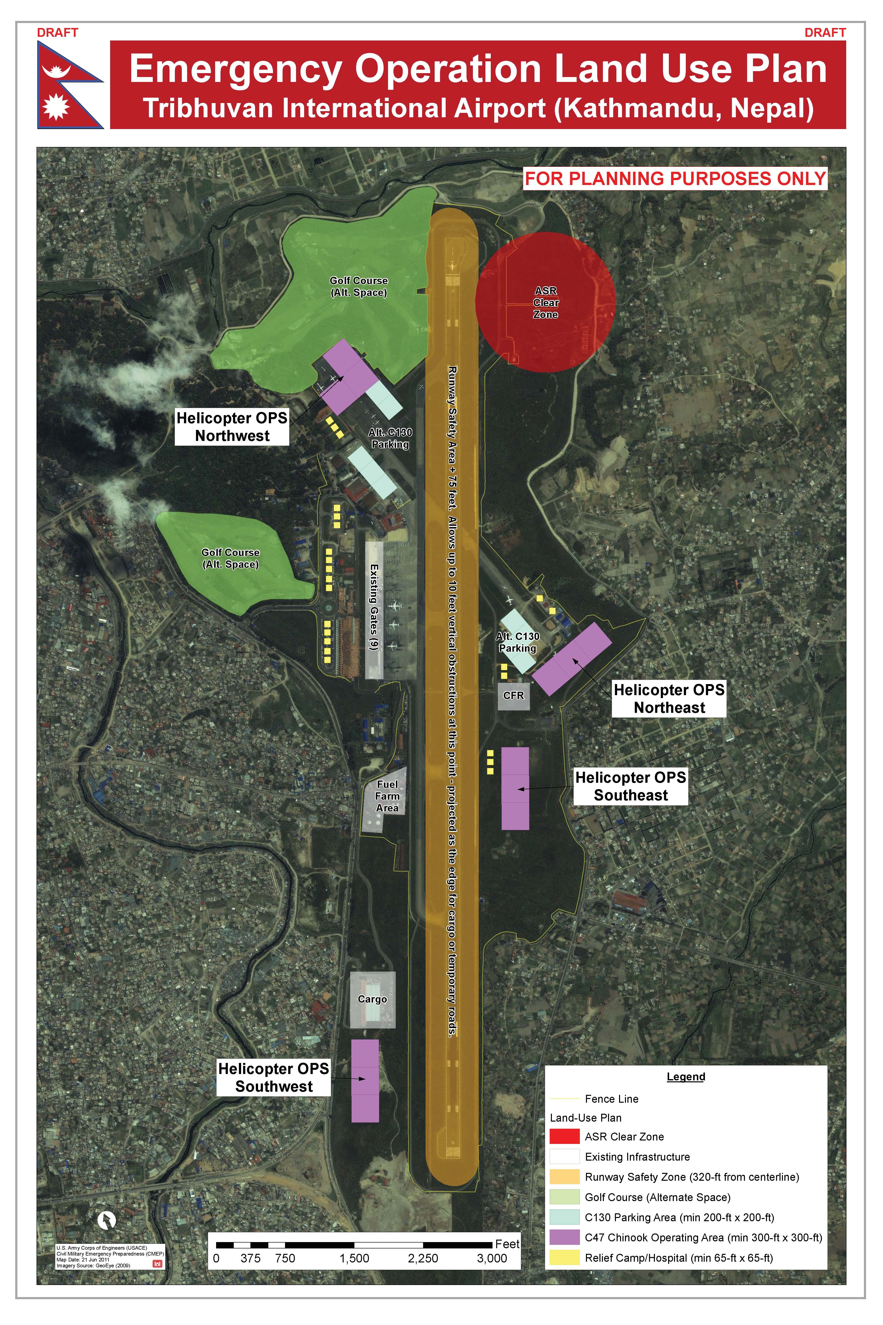
The CMEP program held a recent Seismic Vulnerability Procedures Workshop in Kathmandu, which brought 70 Nepal and U.S. Engineers and Emergency Planners together, to share best practices, procedures, and lessons learned to build capacity in seismic design, inspection, and retrofitting criteria. SMEs from USACE, the Federal Aviation Administration (FAA), the Federal Highway Administration (FHWA), the U.S. Geological Survey (USGS), and the U.S. Agency for International Development (USAID) conducted seismic vulnerability assessments in partnership with Nepal Engineers at four (4) critical bridges in Kathmandu, as well as structural and non-structural elements residing at TIA. U.S. SMEs worked with Nepal's Ministry of Defense (MoD), Ministry of Physical Planning and Works, and CAAN in performing these vulnerability assessments, as well as reviewed guidelines and procedures for conducting future seismic evaluations, retrofitting determinations, and technical structural design criteria. "Priorities for retrofitting action are being established. For example, we now know that a geotechnical soils and pavement investigation is needed at the airport (TIA). We have used GIS to layout where the work should be done first. The results will give us a better understanding of liquefaction potential, slope stability, and the underlying water table levels," stated Justin Pummell, CMEP Program Manager (Asia & Pacific Region). "The next big hurdle will be translating this information to land-use for emergency operations. We have started the process by using GIS to prioritize every piece of real estate at the airfield, and maximize the number of operations that can be conducted to ensure food, water, and other emergency supplies can be distributed as quickly as possible. This will be reviewed by all stakeholders, and the map will be modified accordingly."
The Results
Now that detailed seismic design, retrofitting, and standard requirements have been shared with Nepal Engineers representing academia, government, and NGOs, these experts can take this information and expand upon it. For example, several professors from Tribhuvan University, Kathmandu University, and the National Society for Earthquake Technology in Nepal (NSET) indicated that they plan to incorporate the material discussed at the CMEP workshop into their teaching curriculum. Others representing government organizations stated that they intend to utilize the information in future scopes of work to ensure contractors are accounting for seismic concerns. In summarizing the workshop, one of the participants wrote, "The CMEP workshop gave us the overall idea of our present condition, and showed us the path forward to creative and practical solutions."
The emergency operation preparations at TIA and throughout Nepal will carry on. USACE's CMEP program continues to work with CAAN, NSET, the Nepal Army, the Ministry of Home Affairs, and the Ministry of Planning and Physical Works to ensure emergency plans are developed, and Nepal is better prepared to respond to a large-scale earthquake. CMEP is also working with the U.S. Army Pacific (USARPAC) to conduct a Disaster Response Exercise & Exchange (DREE) in Nepal that will further test and enhance emergency response and preparedness procedures as they relate to seismic activity. GIS will no doubt be at the backbone of these future efforts.
Social Sharing