FORT LEONARD WOOD, Mo. — As the convoy commander for a route never before traversed by coalition forces, you are tasked to move an entire brigade combat team through both manmade structures and existing roads. While preparing for the upcoming combined arms rehearsal, you notice multiple unavoidable bridge structures on the route from the map reconnaissance.
After reviewing the topographic line map of the area of operations, you recognize a potential terrain impact to the mission: can all vehicles convoy over or under these bridges?
You were trained to problem solve, but you need more information than what the initial 2D analysis offers. Your only option may be to send a reconnaissance element into a contested area to gather bridge data.
The need for 3D modeling of terrain and man-made structures is real, and Army geospatial engineers are leading the effort on defining requirements for 3D terrain and man-made structure modeling capabilities within the force.
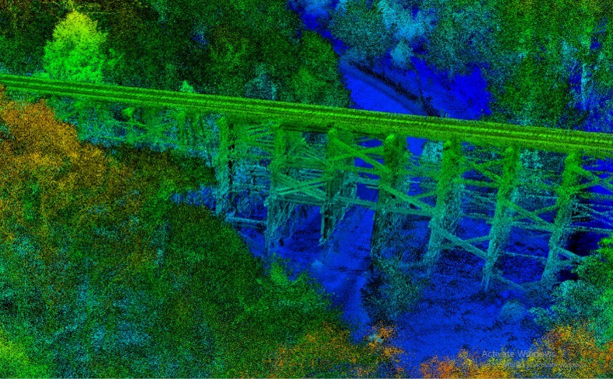
The U.S. Army Training and Doctrine Command Proponent Office - Geospatial recently partnered with the National Geospatial-Intelligence Agency research team in St. Louis, Missouri, and the Army Geospatial Center in Alexandria, Virginia, to collect data on a railroad trestle bridge southeast of Devil’s Elbow, near Fort Leonard Wood.
The Army currently has 3D mapping capabilities but lacks the ability to produce and use 3D models with geospatial accuracy. 3D mapping can be defined as data with x, y, and z values — which exists — whereas 3D modeling is data with x, y, and multiple z values — which is needed.
When 3D maps and models are combined, accurate measurements from a distance become available.
From a geospatial perspective, trestle bridges are complex 3D structures; if this level of complexity can be generated, managed, analyzed and disseminated, other 3D features, such as buildings, should be much simpler.
To collect data on the bridge, the partners used a drone called an Unmanned Aerial Sensor, or sUAS, and a Light Detection and Ranging, or LiDAR, backpack. The drone flew an autonomous, pre-programmed flight path, and the LiDAR captured georeferenced high-resolution imagery and high-precision data of the bridge, which accurately measured components from a set distance.
The data was collected in 30 minutes — available to view in under two hours — and demonstrated the ability to conduct 3D modeling in a disconnected, intermittent and limited bandwidth, or DIL, environment.
The ability to capture a LiDAR scan and process the data without internet connection is significant and directly supports warfighting functions. While LiDAR is not new technology, the capabilities and applications are rapidly expanding.
With LiDAR data collected and imagery overlaid, the end user can visually determine if a route is suitable for convoy operations without deploying troops to gather additional data, reducing risk while aiding in timelier decision making during operations.
Army engineers are depicted as terrain experts and have mastered the art and science of making 2D and 3D maps. As sUAS becomes more capable and available, the ability to provide 3D models within a 3D mapping environment increases, giving a new and refined mission for the geospatial engineer.
The ability to capture and process data without internet connectivity highlights a significant turning point, as well.
Tactical leaders in the not-so-distant future will be able to task a geospatial-capable sUAS to perform engineer reconnaissance on targets, mitigating the risk of deploying a ground element, while enabling a host of other geospatial analytics with the same data.
Social Sharing