
(U.S. Army photo courtesy of Directorate of Public Works, U.S. Army Garrison Fort Benning) VIEW ORIGINAL
Fort Benning Public Affairs
FORT BENNING, Ga. – Every year, from December through May, the Army's burn crews here put on their fire-resistant yellow shirts, brown or green pants and leather boots, and head out in pick-up trucks across Fort Benning's vast woodland acreage, to set expertly controlled fires known as prescribed burns.
They do the burning in areas Fort Benning has set aside for combat and other military training.
The burn crews are made up of forestry and wildlife specialists, and their aim is to burn the deadwood, brush and other debris that accumulates on the forest floor. But they do it based on a careful assessment of wind and other conditions to ensure to the extent possible that the fire stays within the proper space and without smoke traveling off-post and disturbing local homes, hospitals, schools, businesses, roadways, or airports.
Officials here give high importance to prescribed burning because the controlled fires help reduce the number and severity of uncontrolled fires – better known as wildfires – that can pause military training and harm plants and wildlife.
Fort Benning made December through May its annual burn season because that's typically when there's enough but not too much rainfall here, and when wind conditions, temperatures and other factors are suitable for controlled fires.
"I can't say that we chose that season, but that's the season that chose us," said Stephen J. Hudson, a licensed forester who serves as operations section chief with the Natural Resources Management Branch, part of the Environmental Management Division of U.S. Army Garrison Fort Benning's Directorate of Public Works.
"It's all based on our weather patterns and our conditions that time of year here at Fort Benning," he said. "Different parts of the country, different parts of the Southeast, have different burn seasons, based on their climate, and based on their weather patterns. So that's just when ours happens to be."
Besides setting and controlling the fires, the operations section's forestry and wildlife specialists are also trained and equipped to put out any wildfires that may start, any time of year. They handle woodland fires only, not those involving buildings or other structures, which are the job of USAG Fort Benning's Fire Department, Hudson said.

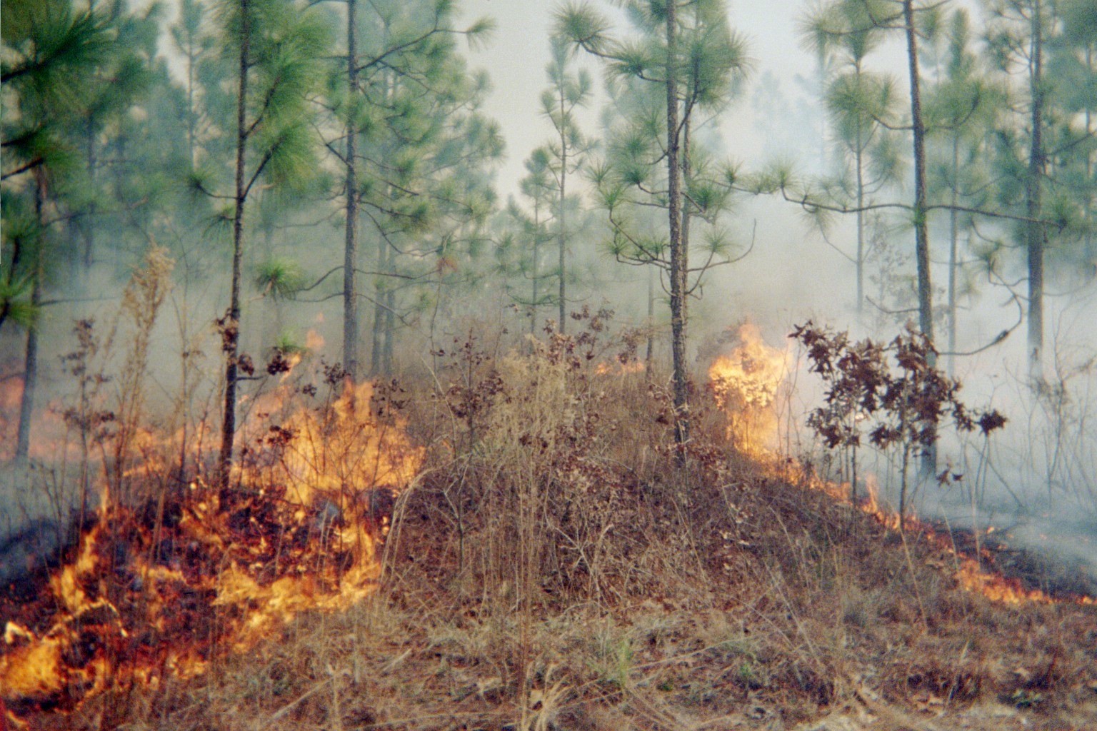
FORT BENNING, Ga. – In a March 2006 photo, a member of a Fort Benning woodland burn crew lays down fire during a controlled burn of unwanted foliage in one of the post's many military training areas. Each year from December through May, Fort Benning conducts expertly controlled burns of deadwood and other debris on the forest floor. Such fires can reduce hindrances to military training while also helping Fort Benning's plant and animal life. Before such burns are scheduled, officials here carefully study weather data, including forecasts as to wind direction, and avoid burning at times or places that might lead to smoke carrying to local homes, hospitals, schools, businesses, roadways, or airports.
(U.S. Army photo courtesy of Directorate of Public Works, U.S. Army Garrison Fort Benning)
VIEW ORIGINAL
In managing its prescribed burn program, Fort Benning marks off its military training acreage in a pattern of alternating sections, similar to a checkerboard. Crews burn in one section, or the other, every two to three years, Hudson said.
"So think of a checkerboard out there of two- to three-year burn cycles," said Hudson. "If I burned the red squares this year; next year I'm gonna burn the black squares."
The sections where they do prescribed burns, called burn areas, vary in size depending on the shape and other characteristics of the particular patch of ground. A burn area can vary from 100 to 1,800 acres. A typical burn session takes three to four hours, start to finish, sometimes less, sometimes more.
Fort Benning overall takes in 284 square miles, or 182,000 acres, said Hudson. For controlled burns of military training areas, they've created 332 burn areas totaling 147,000 acres, he said.
It's happens on a sprawling landscape with a rich diversity of plant and animal life and one in which combat training is underway continually.
That landscape is a habitat for pines and poplars, oaks and elms, and many other kinds of trees, and for Eastern wild turkeys, white-tailed deer, coyotes, foxes, possums, raccoons, feral swine, the gopher tortoise, red-cockaded woodpeckers, two pairs of bald eagles, other bird species, and various snakes, some venomous, including rattlers, among other wildlife.
(U.S. Army photo courtesy of Directorate of Public Works, U.S. Army Garrison Fort Benning)
VIEW ORIGINAL
Prescribed Burns Help Military Training
Training troops for combat is central to the mission at Fort Benning, home of the U.S. Army Maneuver Center of Excellence. MCoE trains Soldiers for the Army's maneuver force – the Infantry and Armor branches, and also trains those hoping to become paratroopers, Rangers, snipers, or to qualify in other military specialties.
Combat training often involves use of incendiary ammunition and devices – tracer rounds, smoke grenades, flares, any of which might touch off a fire.
If during training an unintended fire gets going the Soldiers are required to report it and a crew from the Natural Resources Management Branch is sent to douse the blaze. Once they pull up, training stops until they're done.
It can help matters if the fire broke out in an area at or near a section where there'd been a prescribed burn, said Hudson. Crews can probably get it out quickly because there's not that much lying around to keep it burning.
"It decreases the amount of training downtime," he said. "When we do respond, the time to deal with that wildfire is less, which increases the amount of time the Soldiers can actually conduct their training mission."
And giving an unplanned fire as little as possible to feed on can also reduce the chance that it spreads to mechanical pop-up targets and other equipment that may be in place in the training area. That too helps keep training going, and avoids spending money to replace damaged equipment, Hudson said.
Prescribed Burns Help Plants, Animals
But prescribed burns also help the Army in its careful stewardship of the natural environment, including plant and animal life.
"Fires makes the forest healthy," said Hudson.
The burning leads to chemical changes that release nutrients into the soil, enriching plants. It also burns off foliage that was in the sun's path, allowing sunlight to reach the forest floor. The enriched soil and sunshine together lead to more plant growth and insects in that area, and that means more food for wildlife: plants for grazing animals like deer, for example, and insects for birds.

(U.S. Army photo courtesy of Directorate of Public Works, U.S. Army Garrison Fort Benning)
VIEW ORIGINAL
Weighing Weather Data Before Deciding to Burn
The experts decide dates for prescribed burns only after carefully scrutinizing weather data for a given set of days at Fort Benning, with a focus especially on forecasts as to rain and wind direction.
From his office in a one-story buff-colored building with a green metal roof, Hudson makes daily checks of fire weather forecasts on two websites. One is that of the National Oceanic and Atmospheric Administration (NOAA), which gives real time and long-term forecasts.
"It's a fire weather dashboard for the entire country," said Hudson. "So we can zoom into our particular locations, our particular burn area, and we can get a spot weather forecast. That's gonna tell us all the things we have to know."
They also get online data through the Remote Automatic Weather Stations (RAWS) network, a site that shows hourly weather conditions at Fort Benning based on readings from a small weather station set up near their office building, Hudson said.
"Hourly, it tracks everything we need to know," he said.
Because that weather data also helps spot when wildfires may be likely, it's checked daily, year round. But as December approaches, the aim is to plan prescribed burns.
Once logged in to the websites, Hudson pores over the data displayed in line graphs, bar charts and data tables, checking forecasts as to rainfall, wind direction and speed, and other details needed in spotting when conditions are favorable for the burns. Wind direction is important in avoiding times when it would probably carry smoke to Fort Benning's neighbors.
"Smoke management is knowing where you can burn based on the conditions you have, based on things that you need to keep smoke away from," Hudson said.
"We use different weather parameters to make sure that smoke from that fire is not going to negatively affect any smoke-sensitive areas, whether that's our neighbors, whether that's highways, roadways, airports, and things like that," he said.
The city of Columbus borders Fort Benning's northwestern perimeter, and they plan so smoke won't head west.
"Not only during the burn but nighttime, and the next day," Hudson said. "That way if there's anything left out there that's smoldering, producing smoke throughout the night, then that smoke is going to be blowing away from the city of Columbus."
And what if the conditions for managing smoke fall short of what they want?
"If we don't have good smoke-management conditions for a particular location," said Hudson, "we're not gonna burn it."
Fort Benning maintains an online "Smoke and Sound" information page that tells the public when controlled burns will be occur.
And its Public Affairs Office sends notices to local community organizations and news media for each day a prescribed burn is scheduled.
Big Drop in Wildfires Since Prescribed Burns Began
Fort Benning began prescribed burns in 1981, doing controlled burns of about 7,500 acres a year, said Hudson. The goal is now to burn 45,000 yearly. When they began in the 1980s the outbreak of wildfires here ran to more than 500 a year; it's now down to about 100 a year, he said.
Like Farmers, Hoping for Right Weather
Prescribed burns at Fort Benning halted in mid-March because of the COVID-19 pandemic but have since been cleared to restart.
The burn crews know they'll have a lot of catching up to do once the weather allows things to resume, said Hudson.
So, not unlike farmers who hope for, but can't guarantee, favorable weather, the natural resources management experts will be turning a hopeful eye to the weather, zeroing in on the graphs and data tables for signs of what weather may come, he said.
"I know December's coming up," said Hudson. "I'm gonna start looking very intensely here pretty soon. That's step number one.”
Social Sharing