Managing munitions for the Joint Services is no small task. Headquartered at Rock Island Arsenal, the U.S. Army Joint Munitions Command has stored, distributed, demilitarized, and produced munitions for the Joint Services since 1976. In 2010, JMC implemented an Enterprise Resource Planning (ERP) solution called the Logistics Modernization Program (LMP) to improve munition management across the country. LMP maintains volumes of information about every munition in the inventory; however, reports from LMP are often cumbersome and difficult to visualize. Storage is one of JMC’s critical mission functions, but LMP’s storage reporting shares those same faults. JMC stores munitions in more than 11,000 storage structures across the country, but JMC’s munition storage reports have never fused into a single visual representation. Late last year, JMC was tasked to visualize its storage footprint. That was the catalyst to use information from JMC’s diverse mission areas to finally see our storage footprint.
JMC’s safety office provides a critical mission function for the munitions network. Each of JMC’s mission areas leverage different information technology tools to support the enterprise, but the safety office had the right tool to drive this project forward. Geospatial shapefiles, or files that map storage structures on each installation, are used by JMC’s safety office to maintain required physical separation between explosives in storage. Until December 2019, the

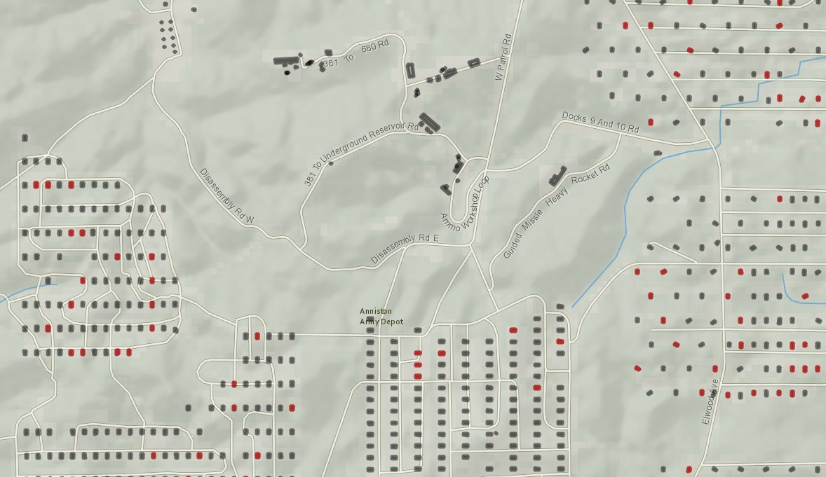
geospatial files that contain storage location information could only be displayed on a handful of computers licensed with expensive commercial mapping software. Although this software can show storage structure locations, it can’t display logistics information from LMP. Seeing our storage structures was a first step, but to answer our task, we needed to identify the munitions within each structure. We needed to link geospatial information with LMP data.
Meanwhile since August 2019, a small cadre of Soldiers and Department of the Army Civilians have been developing an organic analytic capability on Rock Island Arsenal by teaching an open-source analytics software. The programming language at the core of the software can perform a breadth of statistically-based analytic tasks; the complementary Interactive Development Environment (IDE) allows analysts to manage complex tasks and workflows. This software’s baseline capability enables large-scale analysis of LMP’s cumbersome reports. That capability, coupled with the software’s enhanced capability to display geospatial shapefiles, made this analytic software uniquely suited to help JMC visualize its current storage posture.
The result of combining shapefiles and logistics information is incredible. We can finally see color-coded storage structures spread across our installation footprints. The color-coded overlays mapped against our installations add geospatial context to LMP’s storage reports. Viewers can drag, zoom and click on buildings using their baseline computers to see munitions information on a structure-by-structure basis. Previously stove-piped geospatial information is now integrated to give an inclusive look at our munitions storage posture. Leaders can receive munitions logistics information with all the context that a map provides.
JMC has never before been able to see storage quite like this. This is a remarkable new capability for the command and will have far-reaching applications. Storage, distribution, demilitarization, production – valuable applications exist for each one of JMC’s core competencies. Time will tell where we take this new capability, but as the saying goes, a picture is worth a thousand words.
Social Sharing