Introduction
Modern terrain and infrastructure reconnaissance focuses on two things, 1) locating and 2) assessing. When those two things happen, levels of complexity are eliminated and understanding materializes. Location and assessment of infrastructure and terrain for force movement, construction management, base operations and overall decision support optimizes the use of manpower, material and time. They underpin accomplishment of the combat engineering mission.
Computers have become smaller and more powerful. Measuring devices and cameras can be operated at great distance and capture large amounts of data. Improvements to human-computer interaction have made these devices extremely accessible and easy to use. More specialized technologies like Commercial off the Shelf (COTS) Global Positioning Systems (GPS) and Geographic Information Systems (GIS) have transformed map making and land navigation to support multiple often times disparate user communities. Combat Engineers have employed the vast array of COTS technology at their disposal and have revolutionized the military engineering tradecraft.
In 2009, the U.S. Army approved an update to the Military Field Sketching set used by combat engineers. This set was used by soldiers for decades, but had started to collect dust in Army inventories after the 1950s. The updated set included a variety of COTS and Government modified software to aid in engineering calculations, data capture and analysis to replace the plane table, compass, level, and protractors, of its predecessor.
The update to the sketching set evolved into the Instrument Set, Reconnaissance and Surveying, commonly known as ENFIRE. The ENFIRE kit integrates Government off the Shelf (GOTS) and COTS hardware and software components that generate, manage and analyze a wide variety of geospatial and engineering data at a higher degree of fidelity than had been previously possible.
The ENFIRE program modernizes and expedites the collection and dissemination of reconnaissance, construction, facilities planning and project management data for U.S. Army and U.S. Marine Corps engineers. That data and related geospatial information are integrated into one cohesive suite of COTS hardware and software. ENFIRE provides Military Engineers with technologically relevant and continuously advancing capabilities to conduct tactical geospatial data collections from offset locations and to disseminate the data using a variety of transport options (e.g., radios, tactical networks, business networks, etc.) on unclassified or classified networks. The previously employed manual methods are tremendously improved. Collected data is more accurate, the tools are easier to use and information can be shared with decision makers in real time.
ENFIRE is managed by the Product Director Combat Terrain Information Systems (PD CTIS), under the Program Executive Office Intelligence Electronic Warfare & Sensors (PEO IEW&S) / Project Manager Terrestrial Sensors (PM TS). The ENFIRE Program Office operates out of the Army Geospatial Center (AGC). They are continuously fielding ENFIRE to Army Engineer units. Over 1700 systems are in the hands of the soldiers that need them. Another 1100 systems are being built and will be delivered over the next 3-5 years.
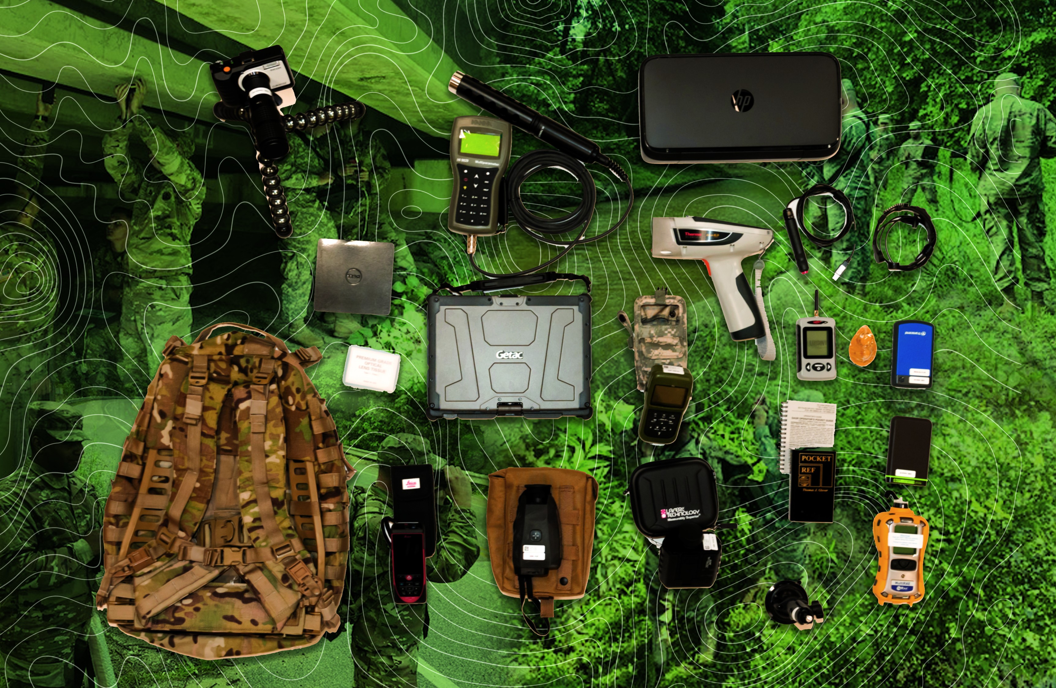
The major hardware components are a touch screen laptop, a variety of laser range finders (LRFs), a military GPS device, inertial measurement unit and digital cameras to capture photos and record video. The ruggedized laptop is pre-loaded with the COTS and GOTS software mentioned earlier and can be operated in all-weather condition even while wearing gloves. In addition the software baseline contains a variety of applications such as Microsoft Office, Microsoft Project, and computer aided design software to aid with engineering and construction management tasks. The ENFIRE reconnaissance package is the core capability. It is a custom GIS application built on ESRI, a leading global GIS provider founded in 1967, software that brings the hardware and software components into a complete, seamless interoperable suite while maintaining the individual utility of the components. ESRI's relationship is well instantiated within the Army and used in many programs which ensure increased interoperability, usage and functionality amongst users and programs.
The ENFIRE Application
The ENFIRE software application is designed to leverage advances in technology, be touch-friendly, and interoperate with a variety of hardware and software. Calculations are performed using data captured through peripheral devices and auto populated to forms. A modular, open design construct has been employed to address insertion of modern technologies and replacement of components that are at "end of life".
The devices included in the kit interface with the ENFIRE app and its component software. The GPS is used to capture real-time location information and display it on a map or imagery background. LRFs connect to the laptop and are used to transfer offset locations and other distance measurements to the ENFIRE application. Soldiers using these tools can conduct reconnaissance from a distance if needed, which increases safety.
One of the popular features of ENFIRE is the Road Reconnaissance module. Users can now navigate while collecting conditions such as slope and turn radius automatically via a mounted Inertial Measurement Unit (IMU). Additional Points of Interest (POI) can be collected using a throat microphone, so the user interaction can remain hands free.
There are multiple options for Full Motion Video (FMV) capture. FMV devices can be mounted on the front, sides, and rear of the vehicle. Only one camera needs to be connected to the ENFIRE laptop to support geo-referencing; other recorded videos (side and rear) can be added after collection using the road reconnaissance session playback manager. The session playback manager has a timeline based workflow that allows users to "playback" a reconnaissance mission and add data such as additional videos, pictures, audio and text providing a more complete tactical picture.
The ENFIRE bridge reconnaissance capability gives engineers the data and analytical tools needed to assess the relative health of bridges. Using LRF devices users can capture measurements from stand-off positions. A useful feature considering the types of terrain bridges are constructed on. Considering the vast array of bridge types, ENFIRE provides graphic representations of bridge structures and bridge components during the analysis process to aid the soldier in identifying the type of bridge. When measurements are collected, and the proper bridge type is selected, users can automatically calculate a Military Load Class (MLC), which is an estimate of the weight that a bridge can support.
Additionally, tunnel, ford, hasty protective minefield, river, IED, environmental baseline, and engineering area reconnaissance are also covered. Additional activities related to accomplishment of military engineering tasks can also be captured. Once collected, ENFIRE makes use of the military standard, MIL-STD 2525C, (for common warfighting symbology) to produce a cartographically correct GIS dataset.
ENFIRE can import and export many GIS formats, and can interoperate with Army tactical systems such as the Distributed Common Ground Systems -- Army (DCGS-A) and the Ground-Warfighter Geospatial Data Model (GGDM) version 3.0. Users can create map packages from virtually any GIS data format. These map packages are imported into ENFIRE as reference layers to aid in giving the combat engineer a better overall tactical picture. Users can also create GeoPackages from georeferenced imagery and vector data, and can ingest GeoPackage formatted data produced by other systems.
Users can take one or more ENFIRE databases and merge them together. This allows soldiers to collect data in parallel, creating time efficiencies when conducting multiple or complex reconnaissance missions. ENFIRE can also export their reconnaissance data to Keyhole Markup Language (KML) and the common shapefile GIS format.
ENFIRE also includes software to develop environmental baselines that support military and civil initiatives. The Environmental Baseline functionality along with the complimentary Joint Construction Management Software were developed by the Army Engineering Research and Development Center (ERDC). These two capabilities support construction management, development of environment profiles for pre and post occupation operations and allow for ENFIRE users to operate in geographically dispersed and or "unconnected" environments while managing resources and efforts. These capabilities support military operations, natural disaster relief, humanitarian aid and similar efforts through the use of common standardized COTS tools.
The Future
Computers continue to become smaller and more powerful. Mobile platforms such as phones and tablets are increasingly important to tactical operations support due to their small form factor. While ENFIRE needs to connect to a wide array of devices, it is possible to develop mobile applications that can support dismounted reconnaissance, route and terrain investigation and other efforts where the use of extremely portable hand held devices are feasible. Collected data can then be synced back to the main ENFIRE database. Feedback from users has shown that many soldiers prefer to use mobile devices when dismounted.
Data interoperability is a core requirement for ENFIRE. Development in the future will remain focused on expanding the data formats and systems ENFIRE can interoperate with while leveraging enterprise services and processing resources to shrink the overall hardware footprint. Support for new data formats will be developed in a plugin-like fashion so that data interoperability support can be updated without the need to reinstall a new version of the software.
Finally, PD CTIS is constantly evaluating technologies such as drones, LIDAR hand held devices and enterprise services for delivery of more robust reconnaissance capabilities anywhere at any time. These future capabilities could deliver video processing, real time analytics, new services and other features that can be coupled with existing fielded solutions to decrease the time needed for decision making, enhance construction management and drive greater efficiencies and outcomes at the "tip of the spear" for the Combat Engineering and Reconnaissance communities . PD CTIS will depend on the evolving commercial capabilities as well as the science and technology investments being made within the Army and Joint domains to drive new paradigms and increase the overall return on investment for the Army and DoD.
Social Sharing