
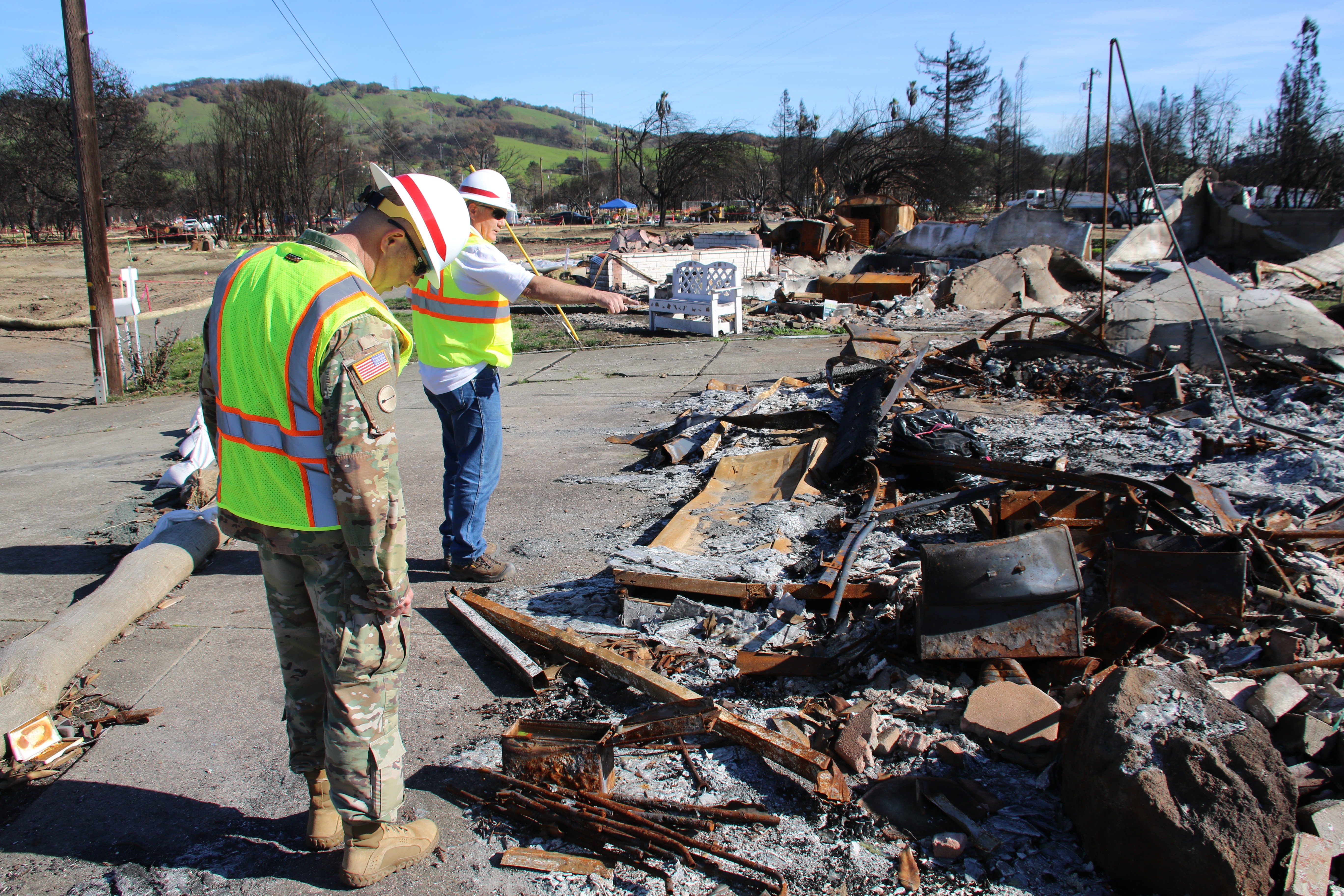


NAPA, Calif. -- Last fall in northern California, blazing wildfires turned lush wine valleys and home developments into debris and ash. Soon after, makeshift tents started rising on the charred landscape.
"Residents didn't want to leave their property," said Marzena Ellis, an hydraulic engineer with the New York District, U.S. Army Corps of Engineers. The residents were holding onto the lives they had before the wildfires, and Ellis was there to help them rebuild those lives.
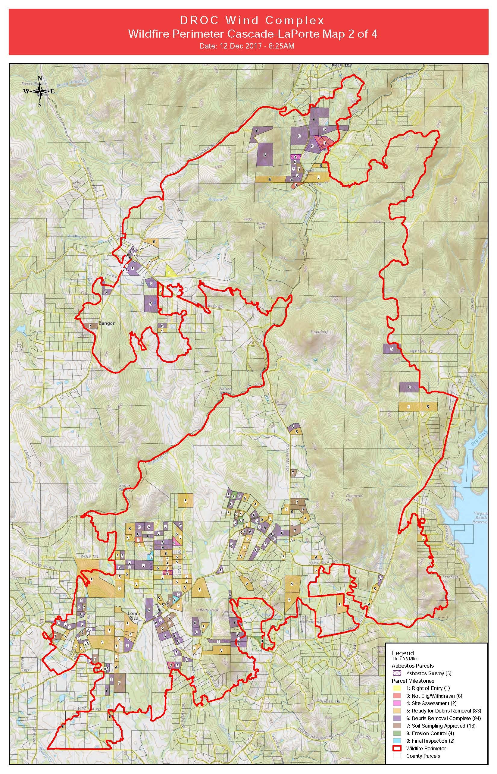
Ellis was one of almost 900 Army Corps volunteers that deployed to California from various Army Corps Districts and Divisions to help with the recovery efforts. Her role was to create maps using Geographic Information System, or GIS, to help with the massive debris removal process.
GIS is a computer-based tool used for capturing, storing, analyzing, and displaying location information. The tool inputs data from various sources, such as aerial photography, and combines these layers of information in various ways to perform analysis and create maps.
In October of 2017, numerous, fast-moving wildfires erupted and burned throughout Northern California, including Napa, Lake, Mendocino, Sonoma, Solano, Yuba and Butte counties.
Over 245,000 acres of land burned, 10,000 structures were destroyed or damaged, and there were 43 casualties. This created the largest debris cleanup in California's history since the 1906 San Francisco earthquake. The Federal Emergency Management Agency called upon the Army Corps to execute the massive debris removal mission.
The Army Corps worked under the direction of FEMA and in partnership with the California's Governor's Office of Emergency Services, as well as other federal, state and local agencies.
The debris clean up mission was performed in two phases. During Phase 1, the California Environmental Protection Agency and the California Department of Toxic Substance Control moved in to remove household hazardous waste.
During Phase 2, the Army Corps and CalRecycle -- California's Department of Resources Recycling and Recovery -- cleared the property lots of ash and fire-related debris.
As of June, 2.2 million tons of debris has been removed from more than 4,500 properties. This is equal to the weight of more than two Golden Gate Bridges, which combined equals 1,774,000 tons.
To assist with the debris removal process, Ellis created maps and performed critical analysis using GIS. She performed this work in collaboration with Arcadis U.S., Inc., a global design, engineering and management consulting company.
This information was used by decision makers in every stage of the mission to perform environmental assessments, debris hauling, and the final cleanup.
This is not the first time the Army Corps' GIS expertise has been taped for major missions. Other missions include the 2007 California wildfires; the cleanup in Manhattan, New York, following 9/11; and the ongoing cleanup efforts in Puerto Rico after Hurricane Maria swept through the island in September 2017.
Using GIS, Ellis created a wide variety of maps that aided in the cleanup of hundreds of private properties, whose owners signed up for the Consolidated Debris Removal Program. The maps were used for debris hauling routes, safety awareness and mission status.
The maps provided the Army Corps and CalRecycle with the most efficient and safest routes around difficult terrain to navigate dumpster trucks and excavators. Wildfire debris -- such as downed trees -- had created narrow, unsafe roads and steep terrain.
Safety awareness maps were created that highlighted properties that had special circumstances noted during the debris removal process. These maps were used by the field and supervisory staff for mission status and safety awareness.
To create these maps and perform analysis, Arcadis crews collected data from the field throughout the lifecycle of the mission. This data featured property site assessment data that included counting the number of buildings on the site, noting any hazardous materials and situations on the site, taking air monitoring measurements and determining the best routes to transport debris.
In addition, Arcadis collected soil samples for testing to ensure the soil was safe for rebuilding. If the site was safe, then erosion control was installed on the property before releasing the land back to the owners.
"By combining our various GIS skillsets and working in collaboration, we were able to quickly formulate action plans and deliver the GIS results requested by crews in the field including Arcadis field crews and CalRecycle," Ryan Miller, a GIS analyst with Arcadis.
CalRecycle greatly appreciated the work of USACE and Arcadis. "The GIS system used by the Army Corps was critical in planning the incident and determining resource allocation, said Todd Thalhamer, CalRecycle operations chief. "Our team worked with the Army Corps to identify where the burned structures were located in each county, the proximity to environmental receptors, location of schools, and to develop an overall plan for the deployment of resources.
"In a disaster of this size -- over three counties -- it was critical to have the most current Intel on where the impacted structures where located," he added.
Miller noted that because of the large number of entities working on this mission, sharing information and having the latest data was important. "It was a common sight throughout the weeks to see supervisors from CalRecycle, FEMA, Arcadis, and private debris hauling contractors all reviewing the maps we created during their discussions of planning and decision making," he said.
"By providing these benefits to the project, we helped to move it forward and meet the rapid response timeline, so that the residents and communities affected by the wildfire could begin rebuilding," he said.
Social Sharing