In February 1995, President William Clinton signed an executive order declassifying early satellite imagery. The release of more than 860,000 photos, taken between 1960 and 1972, has helped scientists explore ancient habitation sites and track environmental changes. It also provided an insight into the early Cold War.
In the 1950s, the United States was making great advances in weapons technology, but the Soviet Union also saw significant gains. In 1953, the Soviets became a nuclear power. Two years later they unveiled a long-range bomber and the intercontinental ballistic missile followed soon thereafter. As the press explored the bomber and later the missile gaps, there was a need to define the threat to the nation. As Adm. William O. Studeman, acting director of the Central Intelligence Agency, observed in 1995, "CORONA was conceived in … an era when facts were scarce and fears were rampant."
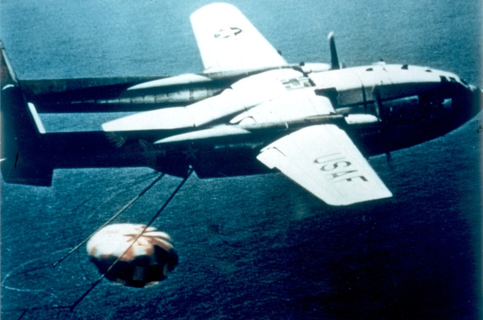
The Corona Project was a highly classified satellite reconnaissance program, developed and tested under an existing Air Force Weapon System 117L -- the Discoverer program. Equipped with a panoramic camera, Corona would fly over and photograph Soviet Bloc countries. The exposed film would then be transferred to recovery vehicles and de-orbited for mid air or ocean recovery. With a parachute slowing the descent, the capsule or "bucket" was captured by an Air Force C-119. In case the aircraft missed, the capsule was designed to float. Navy boats had two days to recover the buckets. After two days, the salt plugs in the capsule would dissolve causing the capsule to sink, preventing the enemy from capturing the film.
With 38 public launches, the Discoverer program was described as an experimental effort developing and testing satellite subsystems and a scientific initiative exploring the environmental conditions in space. It achieved a number of breakthroughs. Discoverer I, launched Feb. 28, 1959, was the first polar-orbiting satellite. Discoverer II, launched April 13, 1959, was the first satellite to be stabilized in orbit in all three axis to be maneuvered on command from earth, to separate a reentry vehicle on command, and to send its reentry vehicle back to earth.
The next major accomplishments for Discoverer/Corona came in August 1960. Launched from Vandenberg Air Force Base atop a Thor-Agena rocket the Corona/Discoverer XIII completed 17 orbits of the Earth. On Aug. 12, 1960, this capsule, which was not equipped with a camera, became the first man-made object recovered from an orbiting satellite. An American flag flown in space aboard the capsule was later presented to President Dwight Eisenhower in a ceremony at the Oval Office.
Six days later came the first fully successful Corona mission. On Aug. 18, 1960, a Corona capsule was launched into space and orbited the Earth for a day. On the next day, the Air Force achieved a mid-air recovery of the Corona XIV capsule with its camera (KH-1) and 20-pounds of film, the first detailed photographic images from space. Flight XIV covered more than 1,650,000 square miles of Soviet territory and produced more images than all of the earlier U-2 missions combined. The age of satellite reconnaissance had begun.
The initial Corona payload involved a single panoramic camera with a resolution of 35-40 feet. In later flights the quality of the cameras and films continued to improve subsequently enhancing the resolution and increasing mission lengths. By the mid-1960s, the program incorporated stereo photographs by tilting the cameras fore and aft as they passed over a particular site. This innovation allowed cartographers, creating maps from the data, to determine terrain relief.
The Corona program came to an end May 31, 1972. Over the course of these 12 years, the Corona program took 800,000 images and 2.1 million feet of film mapping the Earth from space. The primary mission for Corona however had been to collect data and monitor foreign military sites associated with intercontinental ballistic missiles, intermediate-range ballistic missiles, sub-launched missiles, heavy bombers and nuclear energy.
As Studeman observed: "Such pictures held enormous significance for the course of the Cold War. They provided information that allowed our leaders to weigh the Soviet threat and measure our response. Corona debunked the "missile gap" argument. [And,] it allowed us to base our national security strategy - and spending -- on facts rather than fear, on information rather than imagination."
Social Sharing