One of Gen. Douglas MacArthur's topographical drafters had the opportunity to present his perspective of serving with and creating maps for the general during World War II.
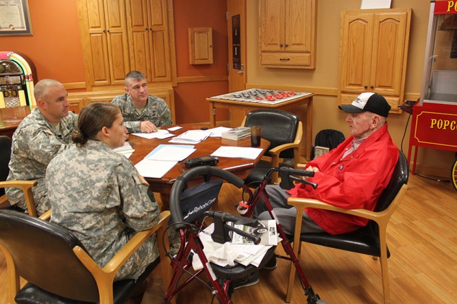
Cadre from the Geospatial Engineer Warrant Officer Education System and the U.S. Army Engineer School's history office interviewed Cordell Queathem earlier this month.
"It was amazing to hear a World War II survivor lived in the St. James Veteran's Home, especially one being a topographer under MacArthur," said Chief Warrant Officer 3 Scott Hashagen, course chief, Army Geospatial Engineer Technician and WOES instructor.
The group traveled to Saint James, Missouri, where Queathem, 91, resides in the Missouri Veterans Home. Queathem served as a topographic drafter for MacArthur from 1943 to the end of the war.
"We were very interested in Queathem's insight on what it was like to be a topographer during World War II," Hashagen said. "For being 91 years old, I was impressed with Mr. Queathem's health, attentiveness and the ability to recall specific events and equipment used."
After completing basic training as a draftee at Fort Belvoir, Virginia, Queathem received additional training on topographical drafting at the University of Kentucky.
During World War II, map production was based in Washington, D.C., but production could not keep up with the demand in the Pacific.
Queathem and two dozen other topographical drafters were sent to MacArthur's headquarters in Brisbane, Australia, to create maps from aerial photography.
Queathem recalled his team produced maps the old-fashioned way -- using stereoscopes and looking at black and white aerial photography of two images of the same area. He said his team used a multiplex machine to create their contour maps.
Such technical talk was music to Hashagen's ears.
"I could relate to stereoscopes, as I was also trained at Advanced Individual Training in 1997 on this equipment to a little extent using light tables and manually creating maps to appreciate today's digital version," Hashagen said.
According to Hashagen, Queathem's team was respected during the war. "He said the topographic team lived well and was highly thought of as a prestigious asset to the war effort by field and general officers," Hashagen added.
Queathem said he was never issued a rifle, but had the prestige of drafting maps in advance of each step in MacArthur's island-hoping campaign.
He said he remained with the unit, as the headquarters moved north to New Guinea and finally into Manila during the Philippine liberation.
Hashagen said Queathem recalled he "could hardly wait to get home from war, as he did what he had to do to serve his country honorably, but missed home tremendously."
"It was an honor and pleasure to meet with Mr. Queathem and his story of what it was like to serve as a topographic analyst during World War II," Hashagen said.
(Editor's note: Capt. Elizabeth Betterbed, researcher, contributed to this article.)
Related Links:
Maneuver Support Center of Excellence and Fort Leonard Wood Facebook
Social Sharing