REDSTONE ARSENAL, Alabama -- With systems designed by members of U.S. Army Space and Missile Defense Command/Army Forces Strategic Command, emergency personnel are prepared for natural, man-made and even spiritual emergencies.
Members of the USASMDC/ARSTRAT Future Warfare Center worked alongside Air Force and National Guard Bureau personnel to develop three tools to support emergency personnel. Those tools are Eagle Vision and Rover Responsive Exploitation of Space Products for Tactical Use, or EVR2EST, Geospatial Information Interoperability Exploitation -- Portable, or GIIEP, and the Information Sharing Dashboard, or ISD.
The ISD pulls the data together allowing all information collected via EVR2EST, GIIEP and other means to be integrated and disseminated to pertinent officials.
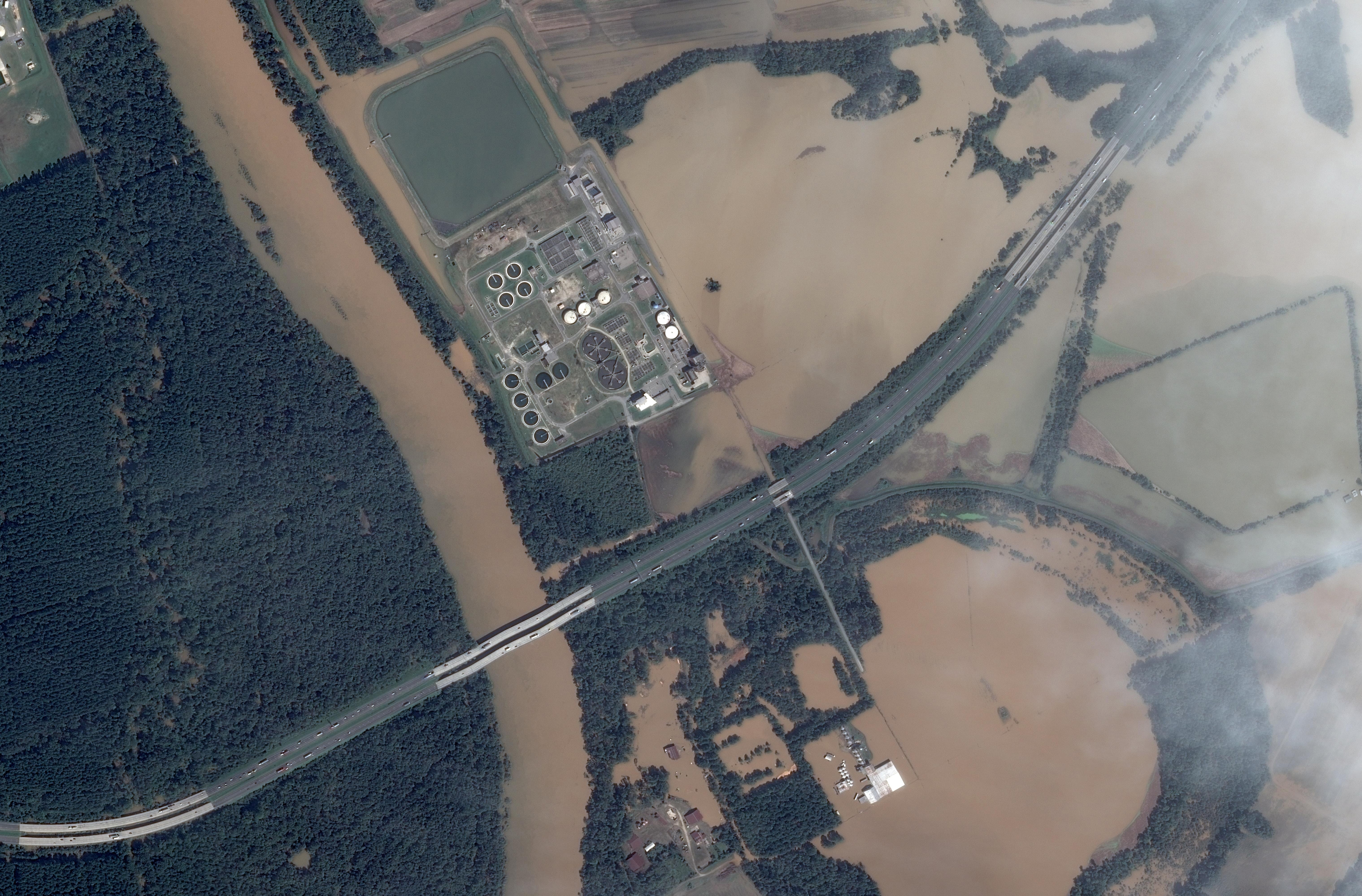
The three tools are currently being used to support local rescue personnel in South Carolina during the October floods, in which more than 178 roads and 73 bridges were closed. More than 1,850 National Guard personnel have mobilized and emergency management teams from Alabama, Florida, Georgia, North Carolina, Mississippi and Tennessee are deployed to support relief efforts.
"We have been providing information sharing capabilities for the space-based imagery, as well as aerial imagery through services like the Civil Air Patrol and others to determine what areas have been flooded and what areas needed additional resources," said Justin Novak, SMDC FWC computer engineer. "To know what is covered and what is not is very important. We provided full motion video from civil support teams as well as providing information exchanges."
With the tools already in place and fielded and the operators are already trained on them, Novak said it is a matter of them taking out the equipment and using it. He said sometimes the first notification they get is when people are already flying missions and sharing information. Then he and others are augmenting that using the information sharing dashboard and the satellite imagery emergency personnel might not be aware of through EVR2EST and pulling all of that together.
"We have all these people, places and things located around the state and it was a challenge to have the information all in one location," Miller said. "We have provided a mechanism allowing all of the information to be distributed. People can be on their phone and receive the information and see it. We helped plan for their response and in the recovery we were able to show imagery of before and after."
Novak said that local rescue units can use Eagle Vision, which is a family of deployable, commercial satellite ground stations that collect and process near real-time optical and synthetic aperture radar imagery from commercial satellites. Commercial satellite imagery is then provided to agencies using the FWC-developed EVR2EST.
"EVR2EST, pronounced Everest, allows the rapid distribution of space-based imagery and radar products generated by the Eagle Vision Program's deployable satellite ground stations," Novak said. "In conjunction with these systems, satellite imagery and radar products can be generated in mere hours after the satellite has collected the information allowing for timely and accurate operational support to Warfighters and first responders."
EVR2EST centralizes commercial satellite imagery by providing a common web-based platform for the U.S. Air Force A2QS Eagle Vision Systems to catalog, archive and disseminate their commercial space-based imagery products. Units from theater-level down to tactical teams and first responders now have access to timely space-based imagery and radar products directly from the deployed ground station on their laptops, tablets and smart phones.
EVR2EST helps support emergency agencies by directing rescue crews to hard-hit areas without them going to unaffected areas or areas that already have units there.
"In the disaster relief and humanitarian assistance roles, EVR2EST supports the mission by rapidly providing critical space-based information to Warfighters and first responders," Novak said. "Information is critical to disaster mitigation planning, search and rescue, and recovery."
The GIIEP system is a man-portable, multi-band receiver that analyzes a variety of visual and textual data, which enhances the ability to respond to disaster situations and provide annotated and compressed imagery products, both still and video, which can be quickly disseminated to mission planners.
GIIEP, pronounced jeep, is an unclassified system developed by the SMDC Battle Lab for the National Guard Bureau -- J-2. All GIIEP products can be accessible via the Internet. Each state and territory National Guard Bureau has received two "Go Kits." They also received two Remotely Operated Video Enhanced Receiver units. They have one ROVER 4 receiver unit and one ROVER 5 transmit/receive unit.
Its purpose is to enable greater use of space-based, aerial and terrestrial imagery combined with a situational awareness picture, collaboration and full motion video to support homeland domestic event response operations.
The summer saw another use for the three tools during a rescue operation as well as the papal visit to the U.S.
"Because of the information being shared, decisions and resources can be made that much quicker," Miller said. "Until now, people thought images from satellites were off limits and they believed that full motion video was not allowed to be seen. The answer now is no, everyone can see them because SMDC has broken down barriers between the Army, Department of Defense and other interagency partners so they can share that information for domestic relief operations and other emergencies like the floods.
"It also saves the government and states money because people are not having to pay for the information over and over," he added. "We are being better stewards of the taxpayers' money. We can share information with the floods, which is an emergency response, to the pope's visit, which is a national special security event, to rescuing a hiker, which is a one-person search and rescue."
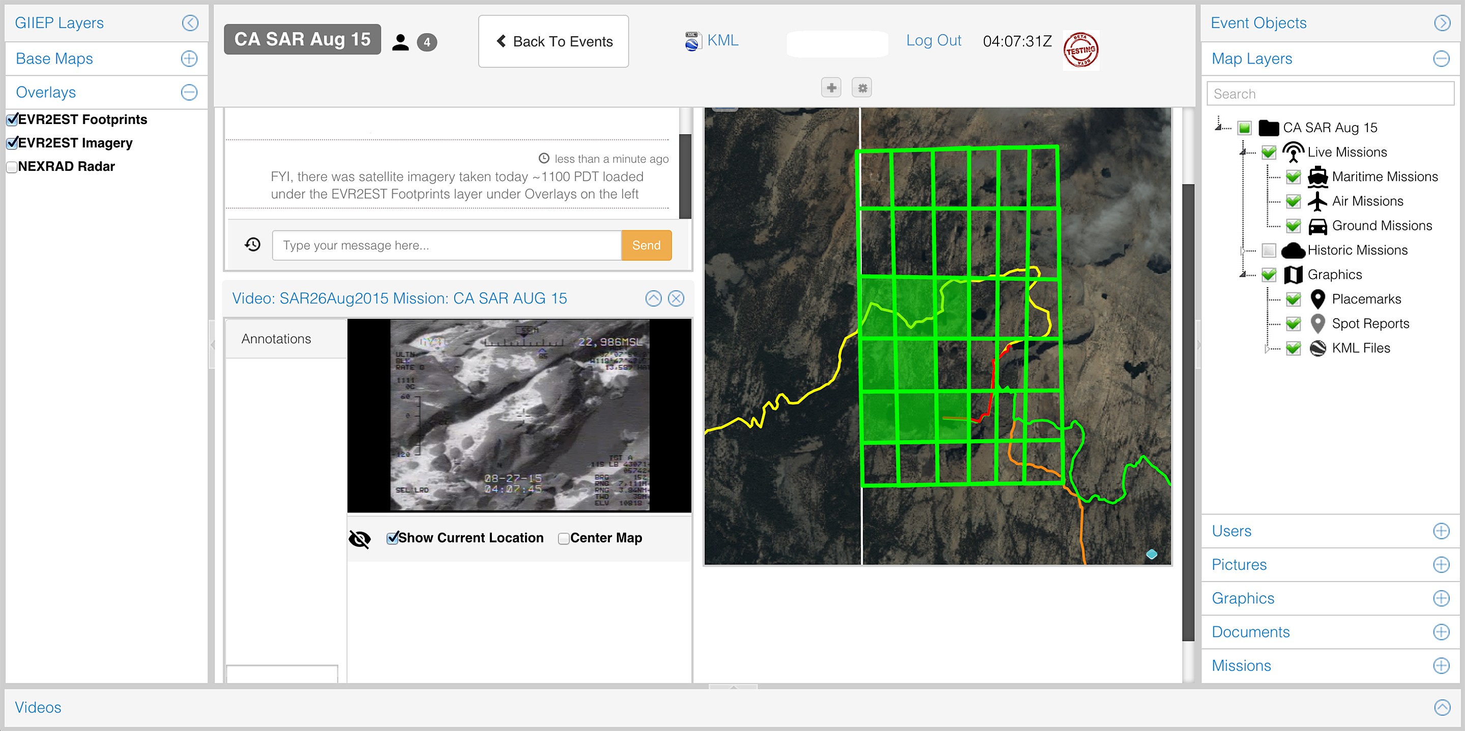
In California, one hiker was rescued after nine days without food in the fire-threatened Californian wilderness in August. Utilizing the three tools, rescue personnel found the hiker near a creek in an area of steep terrain and dense trees. Smoke from a nearby fire hindered the search, preventing aircraft from flying and hampering ground searchers.
"The California National Guard followed their standard operating procedures and launched an aerial platform," Novak said. "The area the hiker was in was located in a search grid they already had on file for recent wildfires. The satellite imagery was instantly available from previous searches and the process was almost instantaneously. They were instantly able to fuse historical data such as roads, hiking trails and landmarks with satellite imagery taken that same day, along with FMV and overlap all search maps.
"Once all of that information was combined, the hiker was located shortly thereafter," he added.
Members of SMDC also helped prepare National Guard and first responders prior to Pope Francis' six-day visit to Washington, D.C., New York City and Philadelphia in September. With GIIEP, EVR2EST and the ISD assets in place, local authorities were prepared prior to the papal visit for unforeseen emergencies.
"It is not what we did, it is what we didn't do," Miller said "They didn't use the tools during the event because nothing happened and that is a good thing. We were in support of three of the U.S. Air Forces Northern's Joint Air Component Command Element teams and we were supporting in the event something happened. If someone needed to respond to a bad thing, we were ready. We were ready at a moment's notice."
After a successful and widely-publicized tour, the pope talked about his first visit to the U.S. and his impressions.
"It was a beautiful thing and also different," Pope Francis said. "Washington, the welcome was warm but more formal; New York was a bit exuberant; Philadelphia very demonstrative."
Social Sharing