CHL's Research Physical Scientist Dr. Honghai Li, along with two of his colleagues, Drs. Alejandro Sanchez and Lihwa Lin, presented a webinar recently at ERDC for district engineers, industry and consulting firm personnel on the use of the Particle Tracking Model (PTM) with the Coastal Modeling System (CMS).
According to Li, the PTM is a Lagrangian model designed to evaluate the transport processes of water-borne constituents, such as sediment, chemicals, debris, or biota based on hydrodynamic, atmospheric and wave forcing.
"CMS is one of the few state-of-the-art waves and hydrodynamic models providing combined wave and current forcing for the PTM," said Li. "The PTM has been jointly developed by the Coastal Inlets Research Program (CIRP) and Dredging Operations and Engineering Research (DOER) program. The CMS has been developed by the CIRP as a numerical modeling system for simulating waves, hydrodynamics, salinity and sediment transport, and morphology change."
The system provides coastal engineers and scientists an efficient tool for understanding coastal processes and for designing and managing coastal inlets, navigation channels, ports, harbors, coastal structures and adjacent beaches.
In addition to monitoring sedment advection and dispersion from dredged material placement sites, the system can assist with forecasting potential increases in turbidity and deposition and can isolate and track particles from other sources such as outfalls and propeller-induced suspension.
"CMS/PTM is interfaced through the Surface-water Modeling System (SMS), which provides a graphic user interface environment for input development, model execution, date pre-and post- processing and visualization in personal computers. It allows users to investigate the transport, fate and pathways of sediment and other waterborne constituents in coastal, estuarine and riverine systems. The PTM's computational efficiency permits short-term (storm cycles) to long-term (seasons to years) analyses of multiple scenarios to determine fate and pathways of sediments during dredging and placement, and transport pathways for coastal, bay and estuarine waterways. The PTM provides a tool to quickly assess multiple scenarios to optimize dredging, dredged material placement, and understand sediment pathways in and around navigation channels, structures, and adjacent beaches," Li said.
The United States, through the U.S. Army Corps of Engineers, has national interest in the stability and evolution of coastal inlets. Nearly $1 billion is spent annually to operate and maintain federal coastal inlet navigation projects, including the inlet channel, associated jetties and breakwaters, inland waterways and stability of adjacent beaches. Understanding how water-borne sediment behaves helps mitigate costs and man hours.
There are many real-life instances where this information is both useful and needed.
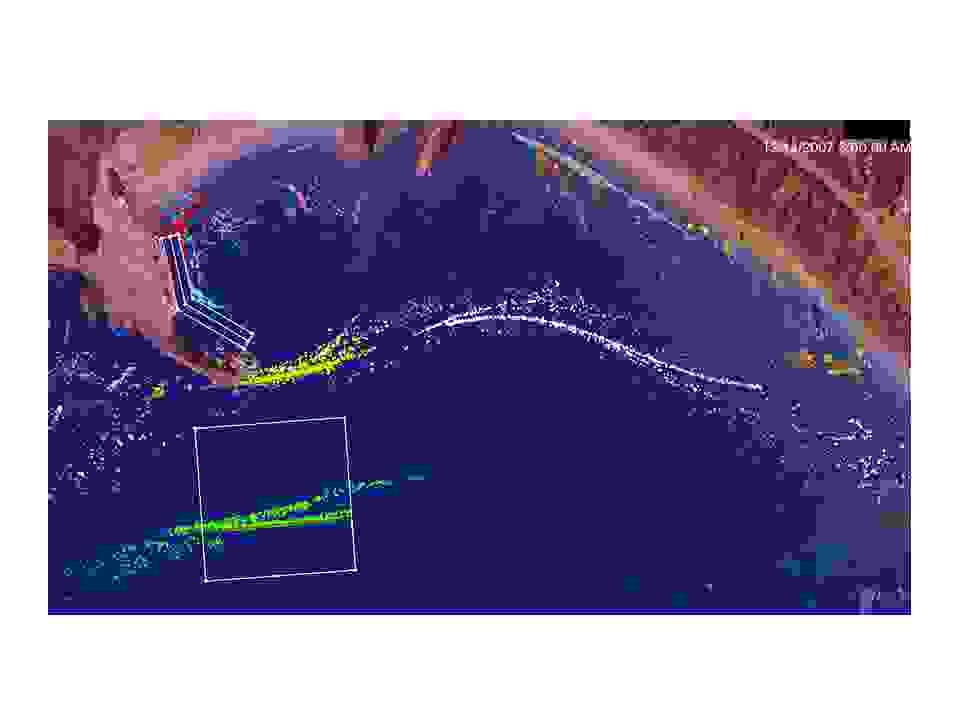
The PTM/CMS was recently applied in a study conducted at the Port of Port Orford, Ore.
The study was conducted to define littoral sediment transport pathways that affect shoaling at the port. Sediment particles were released from selected sources and their movement tracked and investigated. Particle entrainment analysis at the port evaluated environmental conditions to reduce recurring shoaling/dredging costs and proposed a long-term solution to shoaling.
The PTM has been applied in several places in the U.S., including Packery Channel, Texas; Grays Harbor, Wash.; and Providence River in Maine.
These modeling systems are important because coastal inlets are vital to commercial and military navigation for the Corps and other organizations, including the National Ocean and Atmospheric Administration, Environmental Protection Agency, Department of Transportation and wildlife and fisheries agencies.
"These computer programs deliver -- to engineers' desktops -- the practical modeling tools for coastal inlets, coastal navigation channels and adjacent beach studies as requested by our customers and related organizations," Li said.
Social Sharing