COLORADO SPRINGS, Colo. -- The United States Geospatial Intelligence Foundation, or USGIF, selected the U.S. Army Space and Missile Defense Command/Army Forces Strategic Command G-2 Geospatial Intelligence, or GEOINT, Division as the recipient of the Foundation's 2013 Military Achievement Award.
The USGIF annual awards program recognizes outstanding accomplishments in GEOINT tradecraft by an individual or team from the military, government and industry sectors.
USGIF's overall purpose is to promote the GEOINT tradecraft and to develop a stronger community of interest between government, industry, academia, professional organizations and individuals who share a mission focused around the development and application of GEOINT to address national security objectives.
The GEOINT Division is a G-2 staff division at the command's facility on Peterson Air Force Base in Colorado Springs, Colo. The GEOINT Division is also a member of the Army's National-to-Theater, or NTT, GEOINT Federation and is funded primarily by the National GEOINT Program.
This is the first time the Military Achievement Award has been won by an Army Military Intelligence unit in its nine-year history. The award was previously won by the USASMDC/ARSTRAT Future Warfare Center in 2011 for its work in commercial imagery access for disaster relief efforts in support of the Air Force Eagle Vision program and the National Guard Bureau.
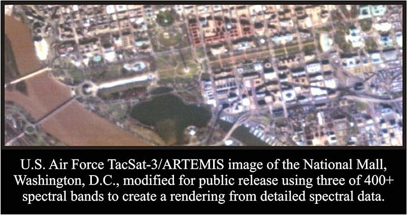
This year's award was based on a past GEOINT Division effort to develop and refine a rapid exploitation process for the Advanced Responsive Tactically Effective Military Imaging Spectrometer, or ARTEMIS, hyperspectral sensor on the Department of Defense experimental TacSat-3 satellite. During the experimental phase of the satellite, exploitation of the satellite's large volume of hyperspectral data by the services and intelligence agencies was taking multiple days to exploit.
The GEOINT Division's image scientists developed a faster process in response to a request from the Air Force Space Command and U.S. Strategic Command to reduce exploitation time to help justify funding for the satellite's follow-on operational phase.
Division member Brian Collins developed and coded the initial process, while image scientist Tim Pachter refined and improved that process. Keith Pence led the GEOINT Division analytical effort as a spectral subject matter expert.
The team reduced exploitation time from days to less than a few hours with the result that the operational phase was funded and the division became the first-phase exploiter of all TacSat-3 imagery for DoD and the National Intelligence Community.
During the course of the 20-month operational phase, the team analyzed and created reports for more than 1,700 hyperspectral image datasets. This effort was a major milestone in the application of hyperspectral sensor technology used for rapid (first phase) exploitation.
The announcement from the USGIF noted "the USGIF Awards Program recognizes the exceptional work and bright minds from all areas of the GEOINT community. Award winners are nominated by their colleagues and selected by the USGIF Awards Subcommittee. The 2013 award winners have demonstrated great achievements in advancing the GEOINT tradecraft."
"We received a record number of nominations for the 2013 USGIF Awards Program and the quality of the submissions was extraordinary," said Kevin Jackson, USGIF's Awards Subcommittee chair. "From the curious high school student's first glimpse into the tradecraft to our trail-blazing veterans, the contributions were significant and meaningful. In every single nomination package there is a story of commitment, passion and unwavering dedication to mission--all intended to make this world a better place."
The Division will receive the award at the USGIF April 2014 GEOINT Symposium.
The article is drawn from the USGIF website and USGIF Nomination that was approved for public release.
Social Sharing