ABERDEEN PROVING GROUND, Md. (Oct. 30, 2013) -- New hardware built by research engineers at the U.S. Army Research Laboratory is helping NASA retrieve experimental images otherwise lost at sea.
The hardware weighs less than two pounds and serves as a means of locating NASA's flight imagery recorders that capture valuable image data of decelerators during deployment and deceleration. It's a small box with a GPS receiver, satellite communications modem, batteries, and a dual band antenna.
NASA's Jet Propulsion Laboratory, or JPL, sought the U.S. Army Research Laboratory's help in "ruggedizing" a locator unit to limit the risk of losing this data, especially in the event of a catastrophic failure.
Missions to Mars are expected to grow in the future "... so NASA needs new technology to slow these big landers from hypersonic entry speed to subsonic ground approach speeds," said Rex Hall, Electronics Technician, Army Research Laboratory, known as ARL, Project Lead Engineer; Flight Imagery Recorder Locator, or FIRLo. He said using atmospheric drag is a solution that would save the rocket engines and conserve fuel for landing.
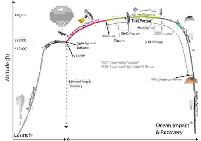
In NASA experiments, large decelerators will be deployed at supersonic speeds and slow the vehicle to safer speeds for the crew and cargo. Hall said that NASA's Jet Propulsion Lab, based in Pasadena, Calif., is leading full-scale stratospheric testing of these technologies.
"The parachute decelerators will slow the vehicle from Mach 2 to subsonic speeds," he said.
The whole experiment is "floated" by a huge balloon to about 120,000 feet then released. A rocket motor is then fired and the Supersonic Inflatable Aerodynamic Decelerator is accelerated to supersonic speed.
"At about 180,000 feet in the air, the rocket motor burns out and the Ringsail chute is deployed. Shortly after the chute is deployed, the large Supersonic Ringsail Parachute is deployed, slowing the whole thing down until impact with the ocean once the experiment is over, or after a catastrophic failure," said Hall, who spent 20 years at Wallops Island, a tiny NASA facility on the Eastern Shore of Virginia as a radio frequency and communication engineer before joining ARL in 2002.
Once on the ocean surface, ARL's FIRLo unit will turn on and transmit a short-burst data transmission, containing location coordinates. This data's location is imposed on a map. Coordinates can also be emailed to the experimenter.
"No specialized receiving equipment is necessary," Hall said.
Time between transmissions is programmed prior to launch and can also be changed via satellite communication while the locator is floating. Battery status is also available in the transmission.
Hall said JPL used an iPhone to locate the FIRLo during a water recovery test this summer.
"The FIR was dropped about five miles off the Pacific coast and left to float for about four hours," Hall explained. "The unit was successfully recovered. The prototype FIRLo was also subjected to a violent water surface impact test at JPL's facility in Pasadena, California. The locator was attached to a structure with the same mass and dimensions of the FIR, and was fired into a pool of water, 24 inches deep, at a velocity of over 70 mph. The FirLo and simulator were supposed to hit the water sideways, but due to a failure of the slingshot-like launch device, the 60-pound structure hit the water, FirLo first!"
ARL's hardware can survive in excess of 10,000 g's, is waterproof and will work when located only 12 inches from the ocean surface, and in temperature extremes below 35 degrees Celsius to 85 degrees Celsius.
The intent is for the FIR to be located and retrieved with specialized GPS receivers and other geo-location hardware that are being leveraged from similar technology previously developed at ARL for Army and Navy high-g guided projectile concepts. The FIR packages with geo-location hardware will be demonstrated in the first quarter of fiscal year 2014, with additional launches to follow.
The first prototype was given to JPL in September. ARL is currently building seven more to be delivered to JPL by the end of the month for use on other experiments.
ARL is supporting new requests for this hardware to support NASA's Sounding Rocket Program tests at White Sands, N.M., and Poker Flats, Alaska, and additional testing in Pasadena, Calif., and off the coast of Kauai, Hawaii.
Related Links:
Army.mil: Science and Technology News
STAND-TO!: U.S. Army Research Laboratory
Social Sharing