THE PHILIPPINE ISLANDS
[2]
CHAPTER I
The Philippine Islands
Since the third century, the Philippine Islands had been under foreign influence, first from Hindu-Malayan empires in Sumatra, Indochina, and Borneo, and then from the Chinese beginning with the early Ming dynasty. Shortly after 1400 Mohammedanism was introduced, and for more than one hundred years all of the islands south of Luzon, and the southern portion of that island, were subject to the Mohammedans of Borneo. During this period, the Japanese established a loose control over northern Luzon and maintained a trading post at Aparri, on the north tip of the island.
European interest in the Philippine Archipelago began with the visit of a Spanish expedition under Ferdinand Magellan in 1521. But it was not until 1565 that the Spaniards established a permanent settlement in the Islands, on Cebu. Five years later they conquered Manila and then gradually extended their control over many of the Islands. Late in the sixteenth century the military ruler of Japan, Hideyoshi, claimed suzerainty, over the Islands. This claim was apparently neither intended nor taken seriously, but the Spanish did pay "tribute" for a short time to avoid trouble, secure trading rights in Japan, and protect the Jesuit missionaries there. Until 1898, despite unsuccessful efforts by the Portuguese and Dutch and one successful effort by the British (1762-1764) to wrest the Islands from her, Spain ruled the Philippines.
The impress of these centuries of foreign influence and control gave to the Philippines a strange mixture of Oriental and Occidental institutions. The original inhabitants were pushed back into the mountains and the Malayans became the dominant racial type. From later invasions came the Mohammedan religion and the Moslem customs prevalent in the south; from China came the impetus to trade and commerce, still largely controlled by the Chinese; and from Spain came the dominant religion, Christianity, the Roman law, and other features of Western civilization.
The United States seized the Philippine Islands from Spain in May 1898 after Admiral Dewey's victory in Manila Bay, during the Spanish-American War. Formal title to the Islands was granted the United States by the Treaty of Paris in December of that year. By the acquisition of the Philippines the United States at one step advanced its frontiers nearly 7,000 miles across the Pacific Ocean and "gave hostages to fortune in a sense which the American people have never fully realized."1 Possession of the Islands made the United States an Asiatic power, with full responsibility for maintaining the peace and status quo in that area.
The government of the Islands was placed in the hands first of a Philippine commission and later of a governor general, both appointed by the President of the United
[3]
States. The Filipinos, once their opposition ended, were allowed an increasingly large measure of self-rule and elected the members of the lower house of the legislature, the Philippine Assembly. In 1913, they were granted free trade with the United States, and three years later, in the Jones Act, were permitted a limited autonomy.
A succession of able American governors established a happy relationship between the two countries, and a steadily increasing sentiment for Philippine independence found ready support in the American Congress. A bill for Philippine independence was passed by Congress, over President Hoover's veto, in January 1933, but vetoed by the Philippine legislature. It was passed again, with some changes, as the Tydings-McDuffie Act, on 24 March 1934, and this time approved by the Philippine legislature.
The Tydings-McDuffie Act provided for the recognition of Philippine independence after a ten-year transitional period. During these ten years the United States would be allowed to "maintain military and other reservations and armed forces" in the Islands, and the President of the United States would have the power "to call into the service of such armed forces all military forces organized by the Philippine Government."2 When the transitional period was over, the United States would abandon all military installations in the Islands.
The Tydings-McDuffie Act left open the question of naval reservations, but authorized the President to negotiate with the Philippine Government for American naval bases in the Islands. The closing date for such negotiations was set at two years after the recognition of independence. Until then "the matter of naval reservations and fueling stations," the Act provided, "shall remain in its present status."3
A year after the passage of the Tydings-McDuffie Act, the Filipinos adopted a liberal constitution based on the American model and established an interim government known as the Commonwealth. Elections in which Manuel Quezon was chosen as president followed soon after, and before the end of 1935 the Philippine National Assembly met to draft plans for local defense.
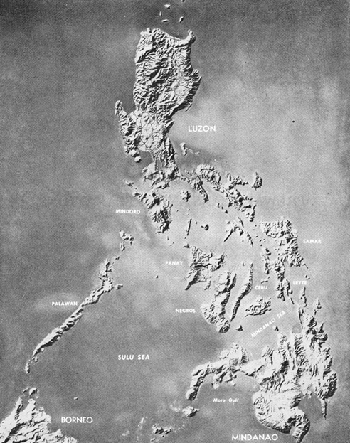
Comprising almost 7,100 known islands and islets, the Philippine Archipelago lies approximately 500 miles off the Asiatic mainland and extends 1,150 miles almost due north and south from Formosa to Borneo. Strategically situated in the geographic heart of the Far East, the Islands are centrally located in relation to Japan, China, Burma, French Indochina, Thailand, Malaya, and the Netherlands Indies. They lie athwart the trade routes leading from Japan and China through the South China Sea to southeast Asia and the rich supplies of oil and minerals in the Indies. Vital areas in Japan and along the Chinese coast are within quick striking distance by sea and air of the Philippines. Over 5,000 miles from Honolulu and 7,000 miles from San Francisco, Manila, the chief city and capital of the Islands, is only 1,800 miles from Tokyo. Formosa and Hong Kong are less than 700 miles distant, Singapore 1,500 miles, and Truk in the Caroline Islands 2,100 miles.4 The Caroline, Marianas, and the Marshall Islands, stretching across the Central Pacific, lie along the
[4]
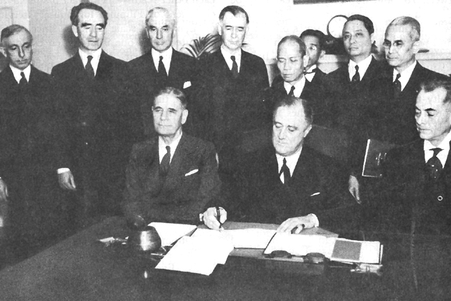
SIGNING THE CONSTITUTION OF THE PHILIPPINE COMMONWEALTH, 23 MARCH 1935. Seated, left to right: George H. Dern, Secretary of War; President Franklin D. Roosevelt, signing the Constitution of the Philippine Commonwealth; Manuel L. Quezon, President, Philippine Senate; standing, left to right: Brig. Gen. Creed F. Cox, Chief, Bureau of Insular Affairs, War Department; Frank Murphy, Governor General of the Philippine Islands; Cordell Hull, Secretary of State; Key Pittman, Chairman, Foreign Relations Committee, U.S. Senate; Pedro Guevara, Philippine Resident Commissioner; Miguel Cuaderno, Vice President, Philippine National Bank, Manila, P. I.; Manuel Roxas, Representative, Philippine Legislature, Delegate, Constitutional Assembly; Francisco A. Delgado, Philippine Resident Commissioner. |
United States lines of communication with the Philippines.
The land area of the archipelago totals about 115,000 square miles. Only 460 of the Islands have an area greater than one square mile, and only eleven boast an area greater than 1,000 square miles. These eleven islands account for 94 percent of the total land area in the archipelago. The largest and most important is Luzon (40,420 square miles) in the north, where Manila is located. Next in size to Luzon is Mindanao (36,527 square miles) in the south, followed by the islands in the central group, the Visayas: Samar, Negros, Panay, Leyte, Cebu, and others.5
The climate of the Islands is tropical, with an average yearly temperature be-
[5]
tween 78° and 80° F. The year may be divided generally into dry and wet seasons, which come at different times on the east and west coasts because of shifts in the seasonal winds or monsoons. From June to September, when the monsoon blows from the southwest, the weather offers little difficulty to the landing of a hostile military force on the favorable beaches along the east coasts. The period of the northeast monsoons, October through April, is the best time for landings along the western China Sea coasts. Most of Mindanao, a portion of the Visayas, and southern Luzon have no dry season and no pronounced maximum rainy season.
The people of the Philippines are mostly of Malayan stock, and in 1941 numbered 17,000,000. In that year, Cebu and central Luzon were the most heavily populated areas, and Manila, with 684,000 inhabitants, was the largest city. There were nearly 30,000 Japanese nationals in the Islands, more than two-thirds of whom were concentrated in Davao, the chief port of Mindanao. The 117,000 Chinese constituted the largest foreign group in the Islands; on Luzon there were almost 9,000 American civilians.
Over sixty-five dialects are spoken in the Islands. When the United States acquired the Islands, a small percentage of the people spoke Spanish; after forty years of American occupation about 27 percent spoke English and 3 percent Spanish. Of the many native dialects, Tagalog, the language of the wealthy and influential residents of central Luzon, was chosen as the basis for a national language in 1937, although twice as many people spoke the Visayan dialect. While the many dialects have certain similarities, it is not possible for the natives in different parts of the Islands to understand each other readily. This fact made the recruitment of Filipinos for military service on a national scale difficult, since troops recruited from one island often could not understand their American or Tagalog officers, or troops from other islands.
The Philippines are predominantly agricultural, the principal crops being rice (the chief element in the Filipino diet), copra, sugar, hemp, tobacco, and corn. The far-ranging mountain areas are a source of gold and silver, and of the more important base metals, such as iron, chrome, manganese, copper, and lead. Sixty percent of the Philippines is covered by forest, much of it hardwoods. The fishing banks off Manila Bay and the Sulu Archipelago supplement the Filipino diet and are the basis of one of the more important industries in the Islands. Even after many years of American occupation there was little manufacturing in the Philippines, most of the inhabitants being engaged in home industries or in the processing of agricultural products such as sugar, hemp, and coconuts.
With interisland and coastal shipping carrying the bulk of Philippine products, there was no great need for roads and railroads. Only on Luzon was there a road and rail net adequate to support large-scale military operations. Of the 14,270 miles of highway in the archipelago in 1940, more than half were in central and southern Luzon. There were only 50,000 motor vehicles in the Islands; the Filipinos relied on the powerful carabao, or water buffalo, for transportation as well as labor. The two railway systems in the Islands, the government-owned Manila Railway Company on Luzon and the American-owned Philippine Railway Company on Panay and Cebu, had a total of 840 miles of narrow gauge track.
[6]
Most of the principal towns and cities were linked by telephone, telegraph, or radio, and all parts of the archipelago by the government postal system. The American- owned Philippine Long Distance Telephone Company connected Manila with most important towns on Luzon, as well as the principal population centers on Panay, Negros, Cebu, and Mindanao. In addition, forty provincial governments operated their own telephone systems so that many small towns and villages had at least one telephone joining them with Manila. Cable connected Manila with Guam, Shanghai, and Hong Kong, and four transoceanic radio stations provided communication with the outside world.
The Philippine Islands are largely mountainous, with elevations as high as 10,000 feet. Narrow coastal plains can be found on most of the islands, and there are numerous short, swift-running streams. Large plain areas and navigable rivers are few. On every island are sand beaches, some of them extensive, but few open on lowlands where there is space for military maneuver.
Luzon, with one tenth of its total area a large plain, and another 5,000 square miles forming a magnificent river valley, is the one island in the Philippines whose terrain permits military operations on a large scale. In the north, closed in by mountains on the east and west, is a valley extending southward for over 120 miles and with an average width of 40 miles. Flowing north through the valley is the Cagayan River. Along the west coast is a narrow plain offering only limited opportunities for military operations. A road runs along this coast from the tip of Luzon towards Manila. Southern Luzon is a volcanic region, part plain and part mountain, with numerous deep indentations forming bays and gulfs, and with many beaches suitable for the landing of a military force.
The central portion of Luzon is composed of a plain extending north about 120 miles from Manila Bay to the Lingayen Gulf. With mountains to the east and west, the plain is well protected from invasion except at its two extremities. It is the most highly developed economic area in the Philippines and the one most suitable for mobile warfare.6
The three most important military highways on Luzon are Routes 1, 3 and 5-two-lane, all weather roads with concrete or asphalt surface. Each enters the capital and each has numerous access roads linking Manila with all parts of the island. Of the 704 miles of railroad on Luzon in 1941, about half were in the central plain, which, in addition, contained 250 miles of private railway lines. All of the road, with the exception of a short stretch above Manila, was single track.
From the South China Sea the southern entrance to the central plain is through Manila Bay, one of the finest natural harbors in the Far East. Opening out from a 12-mile-wide entrance between high headlands, the bay expands toward the low-lying plain to a width of thirty miles. Thirty miles from the entrance lies Manila, and to its north and south are other harbors large enough to shelter seagoing vessels. Mariveles, just inside the northern entrance, is an excellent and easily reached anchorage, and the headland of Sangley Point, where the Cavite naval base was located, has always been recognized as one of the finest ports in the bay.
[7]
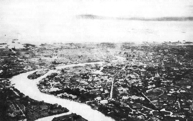
MANILA HARBOR. The Bataan peninsula, partly shrouded in fog and clouds, is visible twenty-five
miles across Manila Bay.
On either side of the entrance to Manila Bay are high volcanic peaks covered with luxuriant tropical foliage. North of the entrance is the Bataan peninsula; to the south is Cavite Province. From a military point of view, the more important and more easily defended of the headlands is the Bataan peninsula, a rocky extension of the Zambales Mountain range which separates the central plain of Luzon from the China Sea.
Across the entrance to Manila Bay are several small islands. The largest and most important, Corregidor, lies two miles off Bataan and, with Caballo, separates the entrance into the North and South Channels. Shaped like a tadpole with its tail to the east, Corregidor measures three and one half miles in length and one and one half miles at its widest point. One mile south of the tip of the tail is Caballo, less than one third the size of Corregidor. In the South Channel, about a mile from the southern headland, lies El Fraile, a rock about 200 by 100 yards jutting up into the entrance of Manila Bay. Just outside and to the south of the entrance is Carabao, the fourth of the small islands whose location in Manila Bay gave them a strategic importance out of all proportion to their size. In the history of American plans for the defense of the Philippines, these islands loom large.
Before the establishment of the Commonwealth Government in 1935, no effort was made to prepare the Philippines for their
[8]
own defense. The United States had assumed all obligations for national defense and maintained a garrison in the Islands for that purpose. This garrison numbered about 10,000 men, half of whom were Philippine Scouts, a U.S. Army unit in which the enlisted men, with some exceptions, were native Filipinos and most of the officers American. After 1913 the Philippine garrison was called the Philippine Department, a regular U.S. Army establishment commanded by an American general officer. The Philippine Constabulary, first organized in 1901, was the national police force, but by training and organization had a military character. Thus, except for their experience with the Constabulary, the Filipinos had had no military tradition upon which to build a national army.7
One of the first problems of the newly established Commonwealth Government was to make provision for the defense of the archipelago. Such a task required a man with proven military and executive ability, and, since there was no likely candidate in the Philippines, the President-elect Manuel L. Quezon turned to the United States for help. In the summer of 1935, he induced his friend, Gen. Douglas MacArthur, then Chief of Staff of the U.S. Army, to become the military adviser to the new government in its effort to organize a national army.8 President Roosevelt's consent was readily obtained and arrangements quickly concluded.
MacArthur's title in his new assignment was Military Advisor to the Commonwealth Government; his mission, to aid in the "establishment and development of a system of National Defense." The authority given him was unusually broad. He was authorized to deal directly with the Secretary of War and the Chief of Staff and, "in all cases not specifically covered," to use his own judgment. "Your mission must be accomplished-," he was told, "ways and means are largely left to you."9 Although there was no official connection between the Philippine Department, the U.S. Army command in the Islands, and the Office of the Military Advisor, the department commander, Maj. Gen. Lucius R. Holbrook, was informed that assistance to General Mac Arthur was "the most important peacetime mission of your command."10
General MacArthur selected Majs. Dwight D. Eisenhower and James B. Ord as his principal assistants. With the aid of a special committee from the Army War College, they prepared a plan to provide the Philippine Commonwealth with a system of national security by 1946, the date the Islands would become independent. This plan called for a small regular army, a conscription system, a ten-year training program of two classes a year to build up a reserve force, a small air force, and a fleet of small motor torpedo boats to repel an enemy landing. The tactical organization of this army was to be based on divisions of approximately 7,500 men. Armament and
[9]
equipment for the new army was to be of a type suitable to the economy and terrain in the Philippines.11
The staff of the Military Advisor was always small. In addition to the officers he took with him, General MacArthur secured the services of four other officers from the Philippine Department when he reached Manila. He also employed as a civilian assistant a retired naval officer, Sidney L. Huff, to advise in naval matters. On the death of Colonel Ord in an airplane accident in 1938, Lt. Col. Richard K. Sutherland was brought into the staff, and when Colonel Eisenhower returned to the United States the next year, Lt. Col. Richard J. Marshall was chosen to replace him. In October 1937, Capt. Hugh J. Casey joined MacArthur's staff to advise in engineer matters, and later Maj. William F. Marquat was designated antiaircraft officer. All of these men remained with General MacArthur through the war years.12
The first legislative measure of the Philippine National Assembly was the passage, on 21 December 1935, of the National Defense Act, which embodied the plan proposed by General MacArthur. In explaining the bill to the Assembly, President Quezon emphasized that the defense program must be carried out economically and should be "passively defensive." It would be impossible for reasons of economy, he declared, to develop an adequate fleet in the short time allotted and with the money available.13
The National Defense Act provided for a regular force of 10,000 men and a reserve force which was expected to reach 400,000 by the middle of 1946. The regular establishment was also to include the Philippine Constabulary, then consisting of about 6,000 men, so that more than half of the regular army from the start consisted of partially trained men. All Filipinos between the ages of twenty-one and fifty were liable for military service. After a 5½- month training period Filipinos would become a part of the reserve force. There were to be two classes a year, each to consist of 20,000 men with the regulars serving as training cadres. For the training of junior officers a military academy patterned after West Point was to be established at Baguio on Luzon. It was expected to graduate about 100 officers each year.14
For military purposes the Commonwealth was divided into ten military districts with functions comparable to those of the prewar corps areas in the United States. Each district had an approximately equal population, and each was to provide initially one reserve division and ultimately three. Luzon, together with several outlying islands (Mindoro, Palawan, Masbate), had five military districts; Mindanao and the Sulu Archipelago together constituted another; and the Visayas four more. In each district the military commander was responsible during peacetime for training and for
[10]
the preparation of defense plans; in time of war for the defense of his district. The provincial governor was responsible for the enforcement of the recruitment and mobilization laws.15
Although the district commanders were responsible for defense plans, the Office of the Military Advisor drew up the plans for all the major islands-Luzon, Cebu, Negros, Panay, Leyte, Mindanao, Bohol, Mindoro-as well as many of the smaller ones. Since these plans were to be employed by the Philippine Government after that nation had received its independence, they were based on the assumption that there would be no U.S. Army forces in the Islands and that all forces would come from the Philippine Army. The plans of the Military Advisor also called for the establishment of seacoast defenses along the seven straits which give access to the inland waters of the Philippine Islands.16
The defense of the coast line-longer than that of the United States-posed an extremely difficult problem. The National Defense Act made no provision for a navy but established in the army an Off Shore Patrol. This organization was to consist of fast motor torpedo boats of a British design. Contracts for thirty-six of these vessels, to be completed by 1946, were placed with British shipbuilders under specifications that called for a boat 65 feet long, with a 13-foot beam, three 12-cylinder engines, and a speed of 41 knots. Armament would consist of two torpedo tubes, depth charges, and light antiaircraft guns.17 "A relatively small fleet of such vessels," said General MacArthur, "... will have distinct effect in compelling any hostile force to approach cautiously and by small detachments."18
The National Defense Act also made provision for an air force, to be utilized primarily for coast defense. By 1946 the Commonwealth expected to have a fleet of approximately 100 fast bombers, supported by other tactical types. They would be used with the Off Shore Patrol to keep hostile craft away from the Philippine coast.
The basic concepts which determined the nature and organization of the Commonwealth military establishment are perhaps best explained by MacArthur himself. The underlying principle, he said in a speech in 1936, was to create a defensive force of such strength as to make an invasion so costly in lives and money that "no Chancellory in the World, if it accepts the opinions of the military and naval staffs, will ever willingly make an attempt to willfully attack the Philippines . . . ." The Islands, MacArthur pointed out, had "enormous defensive advantages" in their geographical separation from possible enemies, mountainous character, heavy forests and jungles, narrow beaches and limited communications. Luzon, the probable objective of an enemy, he reminded his listeners, had only two areas in which "a hostile army of any size could land." "Each of these," he added, "is broken by strong defensive positions, which if properly
[11]
manned and prepared would present to any attacking force a practically impossible problem of penetration."
When the development of the Philippine Army was completed, MacArthur believed it would be strong enough to oppose successfully "any conceivable expeditionary force." It would have a great advantage also in being assigned only one mission: defense of the homeland. Each unit of the army would operate over ground it knew well and which had been "deliberately selected and organized for defense."
The absence of a battle fleet in the plan of defense, MacArthur explained, was due to the defensive mission of the military establishment. The major duty of a large navy, he pointed out, was to protect overseas possessions. For the Philippines, which had no colonies, the only naval task was that of inshore defense. This defense would be provided by "flotillas of fast torpedo boats, supported by an air force," whose task would be to deny the enemy an opportunity to bring its forces close enough to Philippine shores to debark his troops and supplies. All these preparations, he believed, would, by 1946, place the Islands "in a favorable posture of defensive security."19
The development of the Philippine Army was slow. The year 1936 was devoted to the building of camps, organization of cadres, and the special training of instructors, drawn largely from the Constabulary. The commander of the Philippine Department provided Philippine Scouts as instructors and detailed U.S. Army officers to assist in the inspection, instruction, and administration of the program. By the end of the year instructors had been trained and camps established.
The first group of 20,000 men was called up on 1 January 1937 and by the end of 1939 there were 4,800 officers and 104,000 men in the reserves. Infantry training was given at camps scattered throughout the Philippines; field artillery training was concentrated in the vicinity of the U.S. Army's Fort Stotsenburg near Angeles, about fifty miles north of Manila, and specialized training was given at Fort William McKinley just south of Manila. Coast artillery instruction was carried on at Fort Stotsenburg and at Grande Island in Subic Bay by personnel supplied largely by the American commander at Corregidor.20
One of the greatest difficulties encountered in the organization of the Philippine Army was the creation of a satisfactory officer corps. In the Constabulary were Filipino officers with excellent training and experience, but their interests lay in law enforcement rather than military training. Some of the best officers came from the Philippine Scouts; these men rapidly became senior officers in the Philippine Army. The great problem was to train junior officers to command the training camps and reserve units once these were formed. Since no graduates could be expected from the projected military academy at Baguio for four years the most promising men in each semiannual class of reservists were selected for an additional six months' training as noncommissioned officers. The best of these were chosen for officer training and
[12]
became 3d lieutenants upon graduation from Officer Candidate School. Senior ROTC units in colleges and universities were established to provide additional junior reserve officers.
The air program of the Philippine Army, though its development was slow, met with few serious obstacles. The first Philippine Army airfield was built just outside of Manila, and by the time the first runway was completed three trainers were available for pilot training. This course was supplemented by courses in military flying and technical training given in the United States to selected air force students. By 1940 the Philippine Army Air Corps had about forty planes and one hundred trained pilots. Practice in light bombing and gunnery had been given, and the entire instructional system, General Eisenhower observed later, was "on a very sound basis."21
The program for the building of a fleet of motor torpedo boats did not progress well. Only two had been delivered by the end of 1939 when the war in Europe destroyed any hope of securing additional boats from England. An effort was made to produce the torpedo boats locally by purchasing the engines and the right to build from the British design, but by October 1941 only one boat had been completed. Meanwhile, with the assistance of the U.S. Navy, the training of boatmen and mechanics continued.22
No military plan for the defense of an archipelago such as the Philippine Islands could have had serious prospects of success against a determined enemy with a powerful fleet without great reliance on more effective naval support than that provided by patrol boats. The Philippine Government had neither the industrial capacity nor the wealth to build and support a navy which could compete with that of a first class naval power. President Quezon had frankly admitted this in November 1935. Such naval support could come only from the United States. No provision, it is true, had been made in the Tydings-McDuffie Act for the use by the U.S. Navy of naval bases in the Islands after 1946. But such a possibility had not been specifically denied and it was undoubtedly believed that arrangements for their use would be made at a later date. Certainly, the Philippine Government did not anticipate that the United States would stand idly by if the security of the Philippines was threatened.
[13]
Return to Table of Contents
Go to Chapter II
 |
|
Last updated 1 June 2006 |