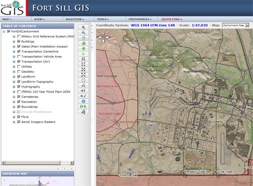
FORT SILL, Okla. - Detailed maps of Fort Sill are probably as old as the post itself, and producing them used to be tedious and time consuming. Now, people can create them with a series of mouse clicks with the Fort Sill Mapper, a Web-based program available to anyone with access to the intranet.
Part of a larger geographic information systems database, the mapper provides hundreds of details on both the cantonment area and training areas. The program ensures all details are properly positioned on maps using grid coordinates. And, while maps may bring to mind basic physical features, such as roads, streams and training areas, the database includes virtually every feature on Fort Sill above and below ground. This detailed data serves as a springboard to launch map applications as varied as the people who develop the ideas.
Working in the Directorate of Public Works, Aaron Peterson is the post geographic information officer. With a wealth of experience spanning 15 years active duty and civil service time, Peterson knows well the capabilities of graphic information systems and the full extent of data available about the post.
“Fort Sill is set up so the whole installation accesses the same data base,” he said. “That provides each user the same detailed data on post property and infrastructure.”
The system is so effective and complete, the Army selected it as a best business practice in December, said Peterson.
To gain a perspective of the system’s value, DPW recently used it to survey all the electrical lines on post and to correct that portion of the post’s real property database.
He said for every real property feature Fort Sill owns, the post may receive money to sustain, revamp or modernize those features.
“Before employing this system we never had a good way of determining the exact linear footage or the electrical rating of power lines on post,” said Peterson. “After resurveying, we found our previous calculations fell short of the total linear footage. We realized an additional $2.35 million that, potentially, could be used to maintain the post’s electrical system.”
He added the database is so complete it sometimes provides greater detail, such as locations of water lines on post, that similar systems used by other federal or state agencies fail to document.
In addition to basic infrastructure applications, Peterson said crime analysis has used the digital mapping device to chart criminal activity and plan patrols. It’s also been used to track work orders for particular facilities on post and document Army and Native American historical sites to preserve cultural information.
Working in an office that has dwindled due to retirement, Peterson is the lone DPW employee who can input information into the database. However, through a working relationship with the Integrated Training Area Management office, the two work centers assist each other keeping the database information current.
Peterson works closely with Spencer Aycock and John Toombs from the ITAM office. Aycock and Toombs mainly focus on GIS uses within the training areas on post, however, all three men assist each other with data input depending on work loads.
Working alongside Range Control, the ITAM office maintains, rehabilitates and constructs training areas on post. The GIS enables the office to specifically account for various features on each training area that increases the accuracy of maps Soldiers need to support their training. Gone are the days of using a basic map and hand drawing overlaying transparencies or in some cases even producing paper maps.
Buddy Leavell, Range Control supervisor, worked that time consuming task as an operations NCO in the 1990s preparing maps and hand drawing an overlay of each individual detail needed for an exercise. The next step in the evolution of local map making had units ordering maps that were produced and printed at Range Control where Soldiers had to pick them up. Leavell said annually they used to get thousands of map requests.
Now Soldiers can access the online mapper and select from hundreds of details to determine with a mouse click what they want on their maps. All the symbols used match existing styles, colors and line widths that Soldiers are trained and familiar with.
“This website fits their needs exactly as they can customize a map to their needs,” said Spencer Aycock, the sustainable range program GIS coordinator.“An aerial photo is the base layer to which Soldiers can add firing and target points, contours, hydrology information and more. Any detail that a standard installation map would contain can be added to these digital maps.”
The program includes an export function which allows users to select a document or image format for printing or importing to a computer briefing program. Products can also be displayed on portable handheld devices for use in the field.
Aside from the map application, Range Control and ITAM also use the GIS for training area rehabilitation and maintenance upgrades. Any time a training area is modified changes are added to the database to ensure Soldiers have the safest environment to train in. Going a step further, the system aids in the development of new training areas by correctly siting firing points so projectiles or ammunition impacts the earth where it’s supposed to land.
Social Sharing