FORT BENNING, Ga. - The next round of meetings for the Training Land Expansion Program is set for May, pending the approval and release of a draft Environmental Impact Statement in mid-April.
Fort Benning is studying the possibility of expanding its training lands by nearly 40 percent in the next five years. The additional training land - roughly 82,800 acres - would allow two heavy maneuver battalions and elements of the Maneuver Center to train simultaneously.
The last major expansion occurred in the 1940s, when Fort Benning's boundaries grew close to where they are today. The draft EIS will outline environmental impacts of actions and alternatives in acquiring land and include feedback from public meetings held in June 2010.
Public meetings were held in five surrounding counties last year and drew more than 600 people. Questions and concerns on the proposed land expansion are still being addressed and will appear in the draft EIS.
A majority of concerns fell into one of the following six categories:
Loss to county tax base
As Fort Benning goes through this process, more definitive answers will be available on effects to county tax revenues. If land is purchased, construction projects, access gates and infrastructure may be needed to support training.
These projects may actually increase county tax revenues and create jobs, said Linda Veenstra, an environmental law specialist with Fort Benning's Office of the Staff Judge Advocate. Veenstra is responsible for ensuring legal requirements are met throughout the environmental impact statement process.
Fort Benning is looking into various combinations of land in order to minimize impacts on any single county's tax base, she said.
Additionally, the Association of County Commissions of Georgia and The Valley Partnership are assisting counties in pursuing measures to offset any tax losses resulting from a land purchase, Veenstra said.
Noise
Residents are concerned about training noise and its effect on land values and quality of life. Fort Benning continues to partner with The Nature Conservancy to add Army Compatible Use Buffer areas around the installation. TNC currently has 7,000 acres in the ACUB program with the dual mission of addressing encroachment - light, noise, smoke and community development - and helping conservation efforts. The ACUB program would extend to provide buffers for any new lands the post purchases and help avoid or reduce noise impacts on the community.
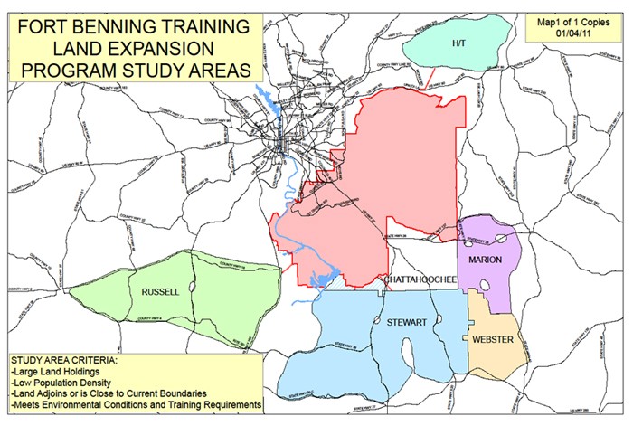
Study areas
Following the initial announcement last April of the Department of Defense's land study approval, residents questioned the lack of definition in the study area map. The map outlined areas in five surrounding counties as possible areas of expansion but had no roads or towns listed as frames of reference, which resulted in many people believing their land was included in the study area, said Kim Raymer, who has fielded hundreds of comments and questions from landowners since the study began last year.
Raymer is a public affairs coordinator for the Training Land Expansion Program.
The Army is in the process of refining the areas of interest and more detailed maps will be presented at future public meetings.
The installation is studying land in Marion, Stewart and Webster counties in Georgia and Russell County in Alabama. Harris and Talbot counties were added to the study area in June after several citizens requested the area be studied and MeadWestvaco contacted Fort Benning concerning approximately 23,000 acres of timberland for sale, she said.
Fort Benning's focus continues to be on large tracts of commercial land close to or adjoining the installation that meet environmental conditions and training requirements.
Eminent domain
Eminent domain was on many landowners' minds at the public meetings, Raymer said, with the perception being that the government "would just take what it wanted."
Nothing could be further from the truth, she said.
It's costly and time-consuming and is considered by the government to be "an absolute last resort," she said.
The rules for eminent domain are regulated by the U.S. Department of Transportation. The Uniform Relocation Assistance and Real Property Acquisition Policies Act of 1970 provides information on the public acquisition of real estate and the rights of landowners.
Raymer said the perception that the Army will move unwilling landowners stems from the 1918 and 1940s expansions of the post.
"They uprooted people ... and that's what the people at these meetings remember. I hear them say, 'You made my granddaddy leave his land.' Things are different now, they've evolved. The Army is truly focused on huge plots of commercial timberland. That's less emotional and doesn't displace families from their land," she said.
In its most limited form, eminent domain refers to the Army invoking its right to acquire land if negotiations with a landowner fail. However, eminent domain in another form can also benefit landowners who want to sell but lack a clear deed to their land.
"Often in the South, land and property may be handed down from person to person and, a lot of times, even if they wanted to sell it they couldn't because they don't have a clear deed. If you do a condemnation, that actually helps them to sell it," she said.
Raymer said some landowners have come forward wanting to sell their land to the government.
The price is determined through a fair market value appraisal. The U.S. Army Corps of Engineers negotiates with the owner to purchase the property.
Appraisals
Raymer said prices are not established by the government. In determining fair market value, land is appraised by an appraiser contracted by the government, she said.
Landowners also have the option of hiring their own appraiser.
The Army adheres to Department of Housing and Urban Development regulations that state the agency must offer just compensation and the amount "cannot be less than the appraised fair market value."
Factors an appraiser typically considers in estimating value of real property include how it compares with similar properties in the area that have sold recently, how much rental income it could produce and how much it would cost to reproduce buildings and other structures, less any depreciation.
Landowners will have the opportunity to accompany the appraiser during the property inspection and inform them of special features.
Perception of a predetermined course of action refuted
Some landowners voiced concerns that Fort Benning had already determined which lands to purchase prior to the start of the study.
Raymer discounts this, saying the addition of Harris and Talbot counties in January disproves it, as well as the fact that if the study concludes it is not in the Army's best interest to purchase training land in the study area, then no land will be purchased.
Harris and Talbot counties were initially ruled out because of ACUB measures being taken along the northern edge of Fort Benning. The post didn't want expansion efforts to interfere with The Nature Conservancy's established buffers.
During public meetings citizens asked about including the two counties and the post looked into it and learned the buffers wouldn't be affected, she said.
Additionally, a land agent contacted the U.S. Army Corps of Engineers' Savannah District to propose that 23,000 acres of contiguous land in the two counties be considered.
The district's real estate division is responsible for making maps of the study areas, organizing land ownership records and keeping track of landowners both interested and not interested in selling land.
The way ahead
The next round of public meetings is tentatively scheduled for May 9-13, pending Army approval of the Draft EIS. To receive announcements, media releases and notification once it is released, e-mail Raymer at land.benning@us.army.mil or call 706-545-8830.
The nearly 1,000-page Draft EIS will be available at local libraries and through Fort Benning's website at https://www.benning.army.mil/garrison/tlep. Citizens will have approximately 45 days from the publication date to comment on the impact statement.
Feedback will be gathered for the final EIS to be completed in the fall. A record of decision on the study could be signed by the Army as early as December.
WHAT IS AN EIS'
The National Environmental Policy Act of 1969 and Army NEPA procedures require the Army to consider the environmental impacts of its proposed actions and alternatives, and to solicit the views of the public so they can make an informed decision regarding how to proceed. The NEPA process will inform Army decision-makers of potential environmental and social impacts that may result from the proposed acquisition of 82,800 additional acres of training land near Fort Benning. They will be able to compare and contrast environmental and socioeconomic impacts of alternative land acquisition locations capable of supporting Fort Benning training requirements.
WHAT ALTERNATIVES ARE BEING CONSIDERED'
The Draft EIS will analyze the potential impacts of six distinct acquisition location alternatives. The alternatives being studied include lands in Harris, Marion, Russell, Stewart, Talbot and Webster. The Army will also analyze the No Action Alternative, which will evaluate the impacts of not acquiring additional training land. Feedback from the public meetings will be considered.
Social Sharing