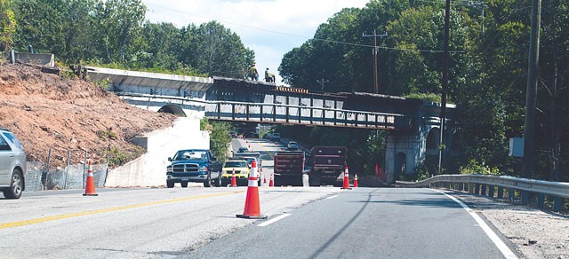
Fort Belvoir, Va. (Sept. 18, 2014) - Depending on your route to and from Fort Belvoir, you might be used to seeing the railroad bridge situated on Route 1 between Tulley and Pence Gates. This railroad bridge has historical ties to Fort Belvoir, and it's going to be torn down soon.
As part of the widening of Route 1, the trestle bridge has to be demolished, said Christopher Daniel, Fort Belvoir's architecture historian, contracted through URS Corporation.
The majority of the bridge will be torn down overnight Sept. 20, said Tim Brown, construction operations engineer, Eastern Federal Lands Highway Division. They began clearing the area resulting in some overnight lane closures last week.
Lanes will be closed through today from 9:30 p.m. to 5 a.m. and 11 p.m. to 5 a.m. Friday.
"They are removing the bridge so they can start the widening work on the southbound lanes," Brown said.
Once they start constructing lanes, traffic will switch to the southbound lanes, which will occur sometime in December, he said.
Present day impact on Route 1
"(The bridge removal) is an engineering feat due to the fact that it's crossing Route 1 and they have to make sure that when they take it out, we don't actually shut down Route 1," Daniel said. "Even with Mulligan Road open, that passageway would be a choke point for traffic."
In addition to traffic implications, and the bridge's historical significance, the bridge had another impact on the Route 1 construction.
"When we started doing the analysis for Route 1 widening, the bridge crossing Route 1, called 1433, was clearly something that was going to have to be looked at," Daniel said. "Right now, the entire portion of Route 1 is right underneath the bridge. That is perfectly sufficient but … if we're going to expand the road, there is no space on either side."
He said the road would run into the concrete abutment of the bridge as a result. Therefore, the Federal Highway Administration had to ask questions and look at how to avoid impacting the historic property, he said, before they could begin the widening proposal.
The Federal Highway Administration offered to do a Historic American Engineer Record, Daniel said.
A professional group of architects and engineers documented the entire rail bridge. The HAER survey makes a technical record of a structure's unique design and style so that in can be filed with the Library of Congress for future study.
Federal Highways will also install historic markers at major railroad crossing points at roadways, said Daniel.
"It is a symbol of the early development of Fort Belvoir," Daniel said. "The crossing was pivotal for this installation to be the way it is now."
History of the rail corridor
The original wood trestle bridge was built in 1918 when Fort Belvoir was called Camp A.A. Humphreys, and was the best way to get materials and people in and out of Fort Belvoir, according to Daniel. It was rebuilt with concrete in 1928 in order to accommodate the heavy loads of construction material used to create many of the brick buildings on post.
"It's a vestige of history that is no longer needed because of its use and its purpose, but was always there because it's a hallmark of times gone by," Daniel said. "Railroads are not in the forefront of everybody's mind now. Here, everyone uses the metro … you don't really think about Fort Belvoir relying on rail line to actually grow, but originally, it was that rail line and the smaller rail line that was actually used to move supplies around post. That was the only thing keeping us going."
As time progressed, the railroad became less significant to the development of Fort Belvoir, he said, especially with the growing use of automobiles.
"All the way up to the 1970s, the rail line was used to bring in coal, some goods and even sometimes more troops, especially at the end of World War II," Daniel said. "But it slowly started to fade away as a viable tool for Fort Belvoir. We were too close to everything else already: there was really no need for rail lines."
The rail line was decommissioned in the 1980s, he said, and it became a utility corridor used for communication, power lines and water. As a result, there are portions of the track that remain, particularly the bridges.
"Because we maintained that corridor by continually using it for different purposes, we actually inadvertently protected the rail corridor," Daniel said. "So, in 2007, the Army had to evaluate the rail corridor as well as the bridges. The requirement made of Fort Belvoir is to meet the National Historic Preservation Act."
According to Advisory Council on Historic Preservation, NHPA requires federal agencies to consider the impact of federally funded projects on historic properties.
Fort Belvoir properties considered historic were evaluated, and by then the rail corridor was coming up to 50 years in age. That was the point at which a resource might be considered historic or a significant resource, Daniel said. It was determined that the bridge maintained the integrity of the original concrete bridges constructed in 1928. The rail corridor was evaluated again in 2009 as a multi-property resource to create the Fort Belvoir Military Railroad.
"The railroad was so important to helping grow the installation. That is the justification for why it was a significant historic resource," he said. "Beyond that we also maintained the corridor even after we stopped using the rail line. To this day, you can actually walk the majority of the corridor."
For more information about Route 1 changes, visit http://rte1ftbelvoir.com.
Social Sharing